Swift Run Gap Topo Map Virginia
To zoom in, hover over the map of Swift Run Gap
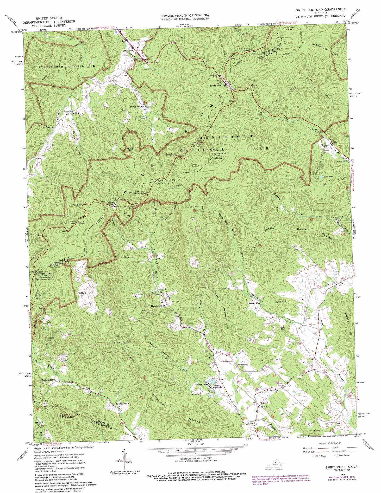
USGS Topo Quad 38078c5 - 1:24,000 scale
| Topo Map Name: | Swift Run Gap |
| USGS Topo Quad ID: | 38078c5 |
| Print Size: | ca. 21 1/4" wide x 27" high |
| Southeast Coordinates: | 38.25° N latitude / 78.5° W longitude |
| Map Center Coordinates: | 38.3125° N latitude / 78.5625° W longitude |
| U.S. State: | VA |
| Filename: | o38078c5.jpg |
| Download Map JPG Image: | Swift Run Gap topo map 1:24,000 scale |
| Map Type: | Topographic |
| Topo Series: | 7.5´ |
| Map Scale: | 1:24,000 |
| Source of Map Images: | United States Geological Survey (USGS) |
| Alternate Map Versions: |
Swift Run Gap VA 1965, updated 1983 Download PDF Buy paper map Swift Run Gap VA 1965, updated 1987 Download PDF Buy paper map Swift Run Gap VA 1977, updated 1982 Download PDF Buy paper map Swift Run Gap VA 1997, updated 1999 Download PDF Buy paper map Swift Run Gap VA 2010 Download PDF Buy paper map Swift Run Gap VA 2013 Download PDF Buy paper map Swift Run Gap VA 2016 Download PDF Buy paper map |
1:24,000 Topo Quads surrounding Swift Run Gap
Broadway |
Tenth Legion |
Stanley |
Big Meadows |
Old Rag Mountain |
Harrisonburg |
Elkton West |
Elkton East |
Fletcher |
Madison |
Grottoes |
Mcgaheysville |
Swift Run Gap |
Stanardsville |
Rochelle |
Crimora |
Browns Cove |
Free Union |
Earlysville |
Barboursville |
Waynesboro East |
Crozet |
Charlottesville West |
Charlottesville East |
Keswick |
> Back to 38078a1 at 1:100,000 scale
> Back to 38078a1 at 1:250,000 scale
> Back to U.S. Topo Maps home
Swift Run Gap topo map: Gazetteer
Swift Run Gap: Crossings
Parrotts Ford elevation 165m 541′Swift Run Gap: Dams
Blue Ridge School Dam elevation 231m 757′Swift Run Gap: Gaps
Powell Gap elevation 703m 2306′Simmons Gap elevation 684m 2244′
Smith Roach Gap elevation 800m 2624′
Swift Run Gap elevation 721m 2365′
Swift Run Gap: Lakes
Goose Pond elevation 557m 1827′Swift Run Gap: Populated Places
Beazley (historical) elevation 216m 708′Beldor elevation 387m 1269′
Cedarmere (historical) elevation 260m 853′
Dyke elevation 195m 639′
Haneytown elevation 254m 833′
Pirkey elevation 231m 757′
Saint George elevation 225m 738′
Sandy Bottom elevation 439m 1440′
Shady Grove elevation 267m 875′
Simmons Gap elevation 650m 2132′
Sullivan (historical) elevation 375m 1230′
Swift Run elevation 415m 1361′
Williams Fork elevation 193m 633′
Swift Run Gap: Post Offices
Beazley Post Office (historical) elevation 334m 1095′Cedarmere Post Office (historical) elevation 260m 853′
Dyke Post Office (historical) elevation 198m 649′
Fernhill Post Office (historical) elevation 723m 2372′
March Post Office (historical) elevation 202m 662′
Nimrod Post Office (historical) elevation 257m 843′
Pirkey Post Office (historical) elevation 231m 757′
Saint George Post Office (historical) elevation 208m 682′
Simmons Gap Post Office (historical) elevation 650m 2132′
Sullivan Post Office (historical) elevation 375m 1230′
Swift Run Gap: Reservoirs
Blue Ridge Lake elevation 231m 757′Swift Run Gap: Ridges
Snow Mountain elevation 619m 2030′Wyatt Mountain elevation 570m 1870′
Swift Run Gap: Streams
Chesley Creek elevation 196m 643′Flatgut Run elevation 351m 1151′
Gum Spring Branch elevation 436m 1430′
Haneytown Creek elevation 182m 597′
Ivy Creek elevation 303m 994′
White Oak Spring Branch elevation 316m 1036′
Yellow Branch elevation 254m 833′
Swift Run Gap: Summits
Brokenback Mountain elevation 527m 1729′Bush Mountain elevation 820m 2690′
County Line Mountain elevation 598m 1961′
Daniels Mountain elevation 520m 1706′
Flattop Mountain elevation 1006m 3300′
Hightop elevation 1091m 3579′
Hunt Mountain elevation 291m 954′
Little Mountain elevation 261m 856′
Parker Mountain elevation 423m 1387′
Roundtop elevation 903m 2962′
Saddleback Mountain elevation 1026m 3366′
Slaters Mountain elevation 501m 1643′
Swift Run Gap: Trails
Beldor Ridge Trail elevation 430m 1410′Saddleback Mountain Trail elevation 918m 3011′
Swift Run Gap: Valleys
Bacon Hollow elevation 255m 836′Bryson Hollow elevation 231m 757′
Deep Hollow elevation 465m 1525′
Eaton Hollow elevation 362m 1187′
Falls Hollow elevation 401m 1315′
Fork Hollow elevation 338m 1108′
Mutton Hollow elevation 279m 915′
Powell Gap Hollow elevation 394m 1292′
Shiffett Hollow elevation 278m 912′
Waterfall Hollow elevation 465m 1525′
Willis Hollow elevation 421m 1381′
Swift Run Gap digital topo map on disk
Buy this Swift Run Gap topo map showing relief, roads, GPS coordinates and other geographical features, as a high-resolution digital map file on DVD:
Western Virginia & Southern West Virginia
Buy digital topo maps: Western Virginia & Southern West Virginia