Madison Topo Map Virginia
To zoom in, hover over the map of Madison
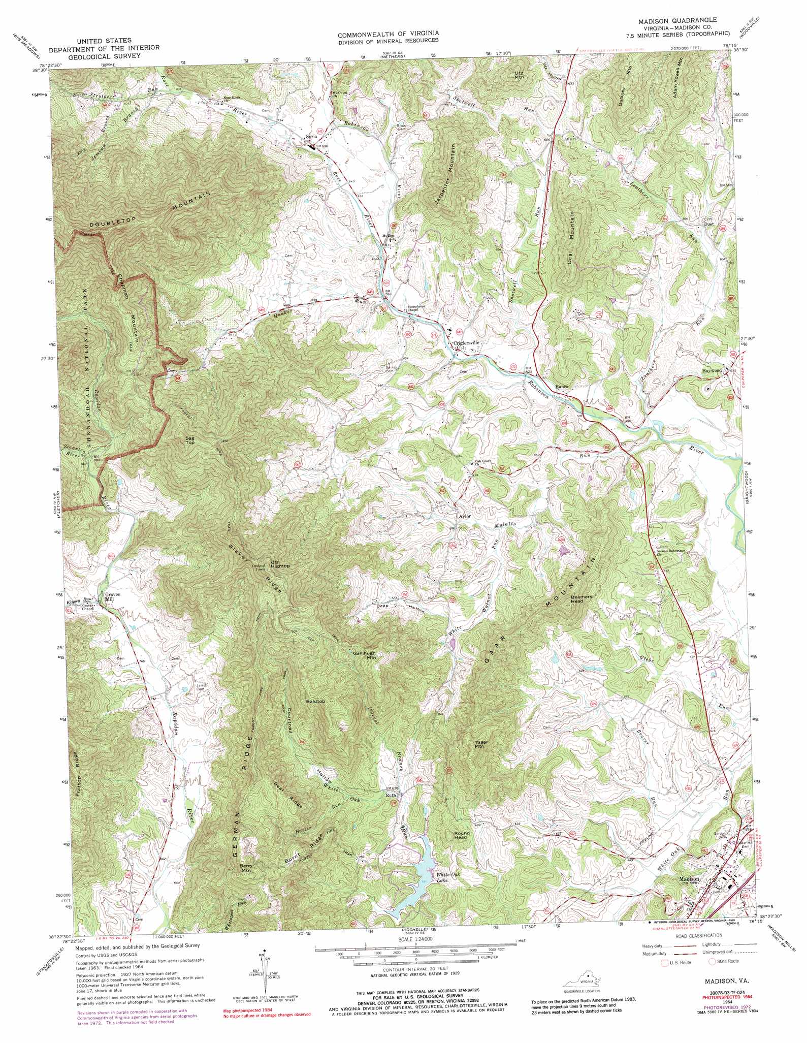
USGS Topo Quad 38078d3 - 1:24,000 scale
| Topo Map Name: | Madison |
| USGS Topo Quad ID: | 38078d3 |
| Print Size: | ca. 21 1/4" wide x 27" high |
| Southeast Coordinates: | 38.375° N latitude / 78.25° W longitude |
| Map Center Coordinates: | 38.4375° N latitude / 78.3125° W longitude |
| U.S. State: | VA |
| Filename: | o38078d3.jpg |
| Download Map JPG Image: | Madison topo map 1:24,000 scale |
| Map Type: | Topographic |
| Topo Series: | 7.5´ |
| Map Scale: | 1:24,000 |
| Source of Map Images: | United States Geological Survey (USGS) |
| Alternate Map Versions: |
Madison VA 1964, updated 1966 Download PDF Buy paper map Madison VA 1964, updated 1972 Download PDF Buy paper map Madison VA 1964, updated 1973 Download PDF Buy paper map Madison VA 1964, updated 1989 Download PDF Buy paper map Madison VA 1964, updated 1989 Download PDF Buy paper map Madison VA 1999, updated 2000 Download PDF Buy paper map Madison VA 2010 Download PDF Buy paper map Madison VA 2013 Download PDF Buy paper map Madison VA 2016 Download PDF Buy paper map |
1:24,000 Topo Quads surrounding Madison
Hamburg |
Luray |
Thornton Gap |
Washington |
Massies Corner |
Stanley |
Big Meadows |
Old Rag Mountain |
Woodville |
Castleton |
Elkton East |
Fletcher |
Madison |
Brightwood |
Culpeper West |
Swift Run Gap |
Stanardsville |
Rochelle |
Madison Mills |
Rapidan |
Free Union |
Earlysville |
Barboursville |
Gordonsville |
Orange |
> Back to 38078a1 at 1:100,000 scale
> Back to 38078a1 at 1:250,000 scale
> Back to U.S. Topo Maps home
Madison topo map: Gazetteer
Madison: Dams
White Oak Dam elevation 178m 583′Madison: Populated Places
Aylor elevation 189m 620′Banco elevation 156m 511′
Criglersville elevation 166m 544′
Duet elevation 173m 567′
Graves Mill elevation 244m 800′
Haywood elevation 191m 626′
Madison elevation 184m 603′
Ruth elevation 189m 620′
Syria elevation 210m 688′
Madison: Reservoirs
White Oak Lake elevation 178m 583′Madison: Ridges
Blakey Ridge elevation 595m 1952′Burnt Ridge elevation 401m 1315′
Deal Ridge elevation 388m 1272′
Flattop Ridge elevation 399m 1309′
German Ridge elevation 398m 1305′
Madison: Streams
Beaver Run elevation 134m 439′Dry Branch elevation 327m 1072′
Finks Run elevation 154m 505′
Finks Run elevation 154m 505′
Hatter Run elevation 157m 515′
Jemima Branch elevation 270m 885′
Kinsey Run elevation 244m 800′
Leathers Run elevation 140m 459′
Mulatto Run elevation 139m 456′
Polecat Branch elevation 188m 616′
Quaker Run elevation 176m 577′
Rose River elevation 183m 600′
Shotwell Run elevation 158m 518′
Staunton River elevation 298m 977′
Strother Run elevation 256m 839′
White Walnut Run elevation 163m 534′
Madison: Summits
Baldtop elevation 499m 1637′Beamers Head elevation 362m 1187′
Berry Mountain elevation 505m 1656′
Carpenter Mountain elevation 403m 1322′
Chapman Mountain elevation 572m 1876′
Deal Mountain elevation 332m 1089′
Gaar Mountain elevation 362m 1187′
Gallihugh Mountain elevation 462m 1515′
Round Head elevation 259m 849′
Sag Top elevation 665m 2181′
Utz Hightop elevation 643m 2109′
Utz Mountain elevation 334m 1095′
Yager Mountain elevation 401m 1315′
Madison: Valleys
Courtney Hollow elevation 197m 646′Deep Hollow elevation 196m 643′
Utz Hollow elevation 193m 633′
Madison digital topo map on disk
Buy this Madison topo map showing relief, roads, GPS coordinates and other geographical features, as a high-resolution digital map file on DVD:
Western Virginia & Southern West Virginia
Buy digital topo maps: Western Virginia & Southern West Virginia