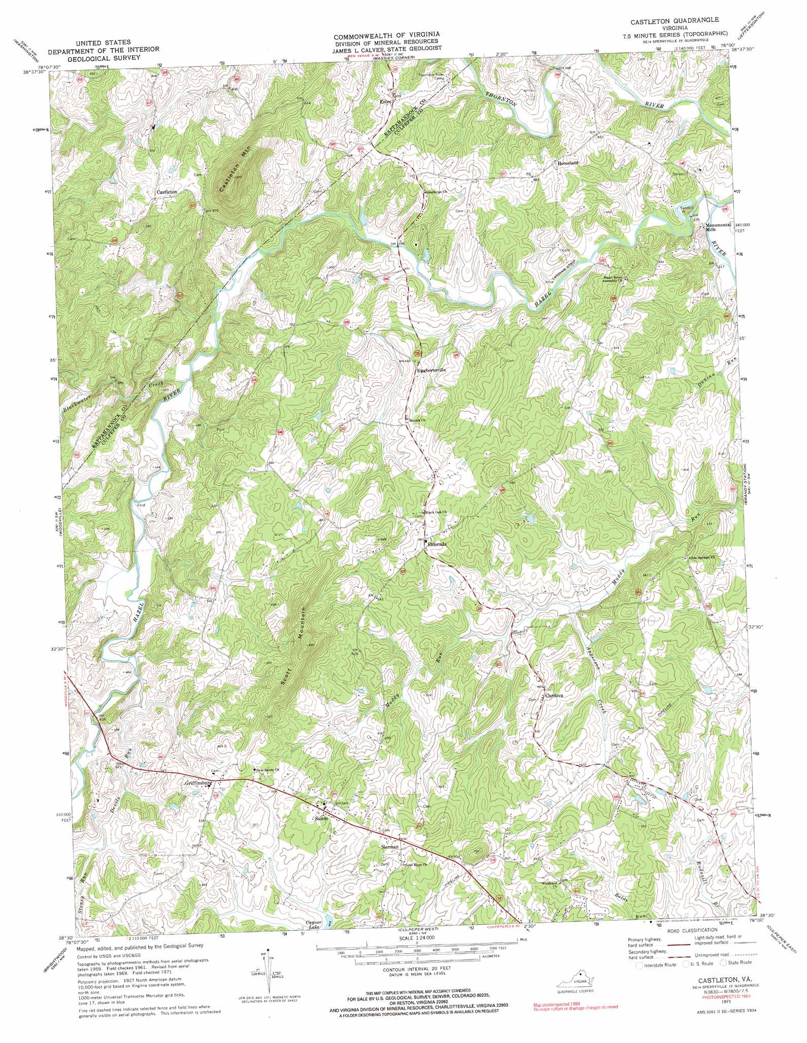
Castleton Topo Map Virginia
To zoom in, hover over the map of Castleton
USGS Topo Quad 38078e1 - 1:24,000 scale
| Topo Map Name: | Castleton |
| USGS Topo Quad ID: | 38078e1 |
| Print Size: | ca. 21 1/4" wide x 27" high |
| Southeast Coordinates: | 38.5° N latitude / 78° W longitude |
| Map Center Coordinates: | 38.5625° N latitude / 78.0625° W longitude |
| U.S. State: | VA |
| Filename: | o38078e1.jpg |
| Download Map JPG Image: | Castleton topo map 1:24,000 scale |
| Map Type: | Topographic |
| Topo Series: | 7.5´ |
| Map Scale: | 1:24,000 |
| Source of Map Images: | United States Geological Survey (USGS) |
| Alternate Map Versions: |
Castleton VA 1971, updated 1972 Download PDF Buy paper map Castleton VA 1971, updated 1972 Download PDF Buy paper map Castleton VA 1994, updated 1997 Download PDF Buy paper map Castleton VA 1994, updated 1997 Download PDF Buy paper map Castleton VA 1994, updated 1997 Download PDF Buy paper map Castleton VA 2010 Download PDF Buy paper map Castleton VA 2013 Download PDF Buy paper map Castleton VA 2016 Download PDF Buy paper map |
1:24,000 Topo Quads surrounding Castleton
Bentonville |
Chester Gap |
Flint Hill |
Orlean |
Marshall |
Thornton Gap |
Washington |
Massies Corner |
Jeffersonton |
Warrenton |
Old Rag Mountain |
Woodville |
Castleton |
Brandy Station |
Remington |
Madison |
Brightwood |
Culpeper West |
Culpeper East |
Germanna Bridge |
Rochelle |
Madison Mills |
Rapidan |
Unionville |
Mine Run |
> Back to 38078e1 at 1:100,000 scale
> Back to 38078a1 at 1:250,000 scale
> Back to U.S. Topo Maps home
Castleton topo map: Gazetteer
Castleton: Dams
Compton Dam elevation 138m 452′Monumental Mills Dam elevation 109m 357′
Castleton: Populated Places
Cardova elevation 155m 508′Castleton elevation 183m 600′
Chesterfield Estates elevation 142m 465′
Eggbornsville elevation 142m 465′
Eldorada elevation 171m 561′
Estes elevation 152m 498′
Fields at Griffinsburg elevation 166m 544′
Griffinsburg elevation 175m 574′
Homeland elevation 153m 501′
Kerrington elevation 138m 452′
Monumental Mills elevation 102m 334′
Norman elevation 183m 600′
Salem elevation 163m 534′
Village at Griffinsburg elevation 163m 534′
West Lakes elevation 158m 518′
Castleton: Streams
Apperson Creek elevation 114m 374′Blackwater Creek elevation 110m 360′
Devils Run elevation 121m 396′
Stoney Run elevation 136m 446′
Thornton River elevation 97m 318′
Castleton: Summits
Castleton Mountain elevation 326m 1069′Davis Mountain elevation 215m 705′
Scott Mountain elevation 263m 862′
Castleton digital topo map on disk
Buy this Castleton topo map showing relief, roads, GPS coordinates and other geographical features, as a high-resolution digital map file on DVD:
Western Virginia & Southern West Virginia
Buy digital topo maps: Western Virginia & Southern West Virginia