Washington Topo Map Virginia
To zoom in, hover over the map of Washington
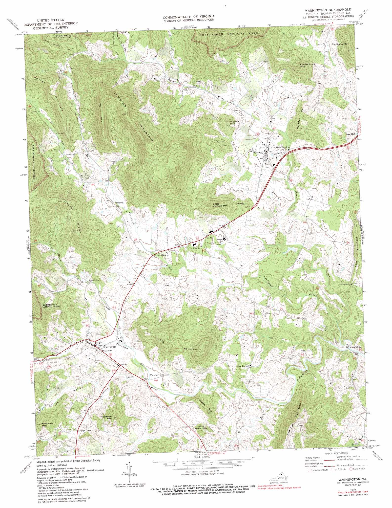
USGS Topo Quad 38078f2 - 1:24,000 scale
| Topo Map Name: | Washington |
| USGS Topo Quad ID: | 38078f2 |
| Print Size: | ca. 21 1/4" wide x 27" high |
| Southeast Coordinates: | 38.625° N latitude / 78.125° W longitude |
| Map Center Coordinates: | 38.6875° N latitude / 78.1875° W longitude |
| U.S. State: | VA |
| Filename: | o38078f2.jpg |
| Download Map JPG Image: | Washington topo map 1:24,000 scale |
| Map Type: | Topographic |
| Topo Series: | 7.5´ |
| Map Scale: | 1:24,000 |
| Source of Map Images: | United States Geological Survey (USGS) |
| Alternate Map Versions: |
Washington VA 1971, updated 1986 Download PDF Buy paper map Washington VA 1994, updated 1997 Download PDF Buy paper map Washington VA 2011 Download PDF Buy paper map Washington VA 2013 Download PDF Buy paper map Washington VA 2016 Download PDF Buy paper map |
1:24,000 Topo Quads surrounding Washington
Toms Brook |
Strasburg |
Front Royal |
Linden |
Upperville |
Rileyville |
Bentonville |
Chester Gap |
Flint Hill |
Orlean |
Luray |
Thornton Gap |
Washington |
Massies Corner |
Jeffersonton |
Big Meadows |
Old Rag Mountain |
Woodville |
Castleton |
Brandy Station |
Fletcher |
Madison |
Brightwood |
Culpeper West |
Culpeper East |
> Back to 38078e1 at 1:100,000 scale
> Back to 38078a1 at 1:250,000 scale
> Back to U.S. Topo Maps home
Washington topo map: Gazetteer
Washington: Dams
Margolis Dam elevation 168m 551′Whippoorwill Dam elevation 206m 675′
Washington: Parks
Sperryville Historic District elevation 210m 688′Washington Historic District elevation 208m 682′
Washington: Populated Places
Ashbys Corner elevation 214m 702′Five Forks elevation 196m 643′
Fletcher Mill elevation 181m 593′
Rediviva elevation 207m 679′
Rock Mills elevation 133m 436′
Rose Hill elevation 178m 583′
Smedley elevation 246m 807′
Sperryville elevation 210m 688′
Washington elevation 208m 682′
Washington: Reservoirs
Margolis Pond elevation 168m 551′Whippoorwill Pond elevation 206m 675′
Washington: Ridges
Pickerel Ridge elevation 499m 1637′Washington: Streams
Beaverdam Creek elevation 180m 590′Big Branch elevation 167m 547′
Covington River elevation 126m 413′
Keyser Run elevation 241m 790′
North Fork Thornton River elevation 194m 636′
Piney River elevation 228m 748′
Racer Run elevation 241m 790′
Rush River elevation 124m 406′
White Walnut Run elevation 150m 492′
Washington: Summits
Big Mulky Mountain elevation 388m 1272′Fodder Stack Mountain elevation 399m 1309′
Ginger Hill elevation 255m 836′
Jenkins Mountain elevation 585m 1919′
Keyser Mountain elevation 510m 1673′
Little Jenkins Mountain elevation 367m 1204′
Little Mason Mountain elevation 244m 800′
Mason Mountain elevation 268m 879′
Massies Mountain elevation 317m 1040′
Menefee Mountain elevation 310m 1017′
Poortown Mountain elevation 324m 1062′
Red Oak Mountain elevation 428m 1404′
Redmans Mountain elevation 358m 1174′
Turkey Mountain elevation 362m 1187′
Wolf Mountain elevation 531m 1742′
Washington: Trails
Gravel Springs Trail elevation 539m 1768′Washington: Valleys
Big Devils Stairs elevation 289m 948′Jenkins Hollow elevation 195m 639′
Washington digital topo map on disk
Buy this Washington topo map showing relief, roads, GPS coordinates and other geographical features, as a high-resolution digital map file on DVD:
Western Virginia & Southern West Virginia
Buy digital topo maps: Western Virginia & Southern West Virginia