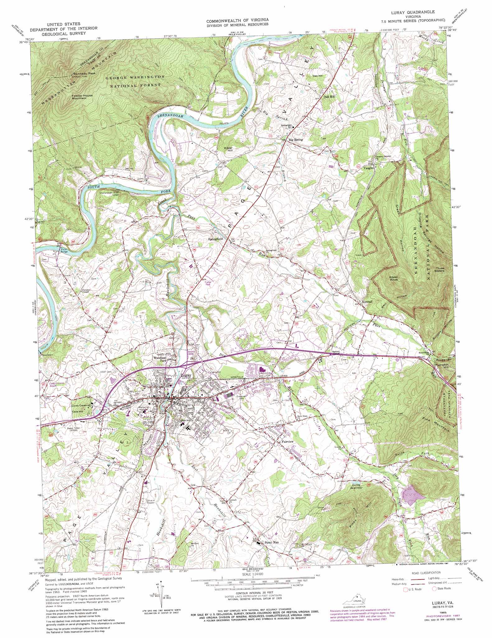
Luray Topo Map Virginia
To zoom in, hover over the map of Luray
USGS Topo Quad 38078f4 - 1:24,000 scale
| Topo Map Name: | Luray |
| USGS Topo Quad ID: | 38078f4 |
| Print Size: | ca. 21 1/4" wide x 27" high |
| Southeast Coordinates: | 38.625° N latitude / 78.375° W longitude |
| Map Center Coordinates: | 38.6875° N latitude / 78.4375° W longitude |
| U.S. State: | VA |
| Filename: | o38078f4.jpg |
| Download Map JPG Image: | Luray topo map 1:24,000 scale |
| Map Type: | Topographic |
| Topo Series: | 7.5´ |
| Map Scale: | 1:24,000 |
| Source of Map Images: | United States Geological Survey (USGS) |
| Alternate Map Versions: |
Luray VA 1965, updated 1966 Download PDF Buy paper map Luray VA 1965, updated 1973 Download PDF Buy paper map Luray VA 1965, updated 1987 Download PDF Buy paper map Luray VA 1972, updated 1974 Download PDF Buy paper map Luray VA 1994, updated 1997 Download PDF Buy paper map Luray VA 2011 Download PDF Buy paper map Luray VA 2013 Download PDF Buy paper map Luray VA 2016 Download PDF Buy paper map |
| FStopo: | US Forest Service topo Luray is available: Download FStopo PDF Download FStopo TIF |
1:24,000 Topo Quads surrounding Luray
Wolf Gap |
Woodstock |
Toms Brook |
Strasburg |
Front Royal |
Conicville |
Edinburg |
Rileyville |
Bentonville |
Chester Gap |
New Market |
Hamburg |
Luray |
Thornton Gap |
Washington |
Tenth Legion |
Stanley |
Big Meadows |
Old Rag Mountain |
Woodville |
Elkton West |
Elkton East |
Fletcher |
Madison |
Brightwood |
> Back to 38078e1 at 1:100,000 scale
> Back to 38078a1 at 1:250,000 scale
> Back to U.S. Topo Maps home
Luray topo map: Gazetteer
Luray: Bridges
Bixler Bridge elevation 208m 682′Luray: Crossings
Bealers Ferry (historical) elevation 197m 646′Ruffner Ferry (historical) elevation 212m 695′
Stricklers Ferry (historical) elevation 205m 672′
Luray: Dams
Dry Run Number 101 Dam elevation 341m 1118′Luray Dam elevation 222m 728′
Luray: Populated Places
Big Spring elevation 230m 754′Brookside elevation 250m 820′
Fairview elevation 279m 915′
Forest Hills elevation 290m 951′
Hilldale elevation 267m 875′
Kimball elevation 279m 915′
Luray elevation 243m 797′
Oak Hill elevation 252m 826′
Spring View elevation 285m 935′
Springfield elevation 224m 734′
Stony Man elevation 278m 912′
Vaughn elevation 292m 958′
Westlu elevation 274m 898′
Woodland Park elevation 246m 807′
Luray: Post Offices
Luray Post Office elevation 250m 820′Luray: Reservoirs
Lake Arrowhead elevation 341m 1118′Luray Reservoir elevation 327m 1072′
Luray Reservoir elevation 222m 728′
Luray: Streams
Big Spring Branch elevation 202m 662′Dry Run elevation 230m 754′
East Hawksbill Creek elevation 240m 787′
Hawksbill Creek elevation 204m 669′
North Fork Dry Run elevation 314m 1030′
Pass Run elevation 213m 698′
Rocky Branch elevation 298m 977′
South Fork Dry Run elevation 317m 1040′
Luray: Summits
Cave Hill elevation 323m 1059′Fodder House Mountain elevation 576m 1889′
Kennedy Peak elevation 771m 2529′
Kibler Hill elevation 295m 967′
Kibler Knob elevation 502m 1646′
Oak Hill elevation 300m 984′
Pine Mountain elevation 530m 1738′
Piney Hill elevation 491m 1610′
Three Sisters elevation 636m 2086′
Luray: Valleys
Bell Hollow elevation 280m 918′Britton Hollow elevation 296m 971′
Dripping Springs Hollow elevation 283m 928′
Green Hollow elevation 274m 898′
Luray digital topo map on disk
Buy this Luray topo map showing relief, roads, GPS coordinates and other geographical features, as a high-resolution digital map file on DVD:
Western Virginia & Southern West Virginia
Buy digital topo maps: Western Virginia & Southern West Virginia