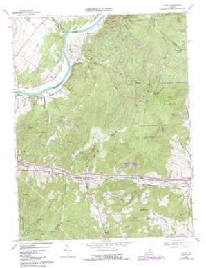
Linden Topo Map Virginia
To zoom in, hover over the map of Linden
USGS Topo Quad 38078h1 - 1:24,000 scale
| Topo Map Name: | Linden |
| USGS Topo Quad ID: | 38078h1 |
| Print Size: | ca. 21 1/4" wide x 27" high |
| Southeast Coordinates: | 38.875° N latitude / 78° W longitude |
| Map Center Coordinates: | 38.9375° N latitude / 78.0625° W longitude |
| U.S. State: | VA |
| Filename: | o38078h1.jpg |
| Download Map JPG Image: | Linden topo map 1:24,000 scale |
| Map Type: | Topographic |
| Topo Series: | 7.5´ |
| Map Scale: | 1:24,000 |
| Source of Map Images: | United States Geological Survey (USGS) |
| Alternate Map Versions: |
Linden VA 1966, updated 1968 Download PDF Buy paper map Linden VA 1966, updated 1973 Download PDF Buy paper map Linden VA 1966, updated 1980 Download PDF Buy paper map Linden VA 1966, updated 1984 Download PDF Buy paper map Linden VA 1966, updated 1987 Download PDF Buy paper map Linden VA 1972, updated 1977 Download PDF Buy paper map Linden VA 1986, updated 1987 Download PDF Buy paper map Linden VA 1994, updated 1997 Download PDF Buy paper map Linden VA 2010 Download PDF Buy paper map Linden VA 2013 Download PDF Buy paper map Linden VA 2016 Download PDF Buy paper map |
1:24,000 Topo Quads surrounding Linden
> Back to 38078e1 at 1:100,000 scale
> Back to 38078a1 at 1:250,000 scale
> Back to U.S. Topo Maps home
Linden topo map: Gazetteer
Linden: Airports
Aspen Hill Airstrip elevation 159m 521′Linden: Bridges
Morgans Ford Bridge elevation 131m 429′Linden: Crossings
Interchange 13 elevation 246m 807′Morgan Ford elevation 132m 433′
Linden: Dams
Apple Mountain Lake Dam elevation 240m 787′Apple Mountain Upper Lake Dam elevation 255m 836′
Cloud Dam elevation 187m 613′
Deer Dam elevation 402m 1318′
Loch Linden Dam elevation 218m 715′
Spring Lake Dam elevation 255m 836′
Linden: Gaps
Manassas Gap elevation 287m 941′Linden: Populated Places
Apple Mountain Lake elevation 291m 954′Apple Mountain Lake West elevation 261m 856′
Applewood elevation 237m 777′
Belle Meade elevation 225m 738′
Blue Mountain elevation 426m 1397′
Harrell Corner elevation 335m 1099′
Howellsville elevation 144m 472′
Linden elevation 287m 941′
Linden Heights elevation 487m 1597′
Loch Linden elevation 310m 1017′
Markham elevation 176m 577′
Monterey Orchards elevation 372m 1220′
Petersburg elevation 240m 787′
Shenandoah Farms elevation 165m 541′
Skyland Estates elevation 502m 1646′
Linden: Post Offices
Linden Post Office elevation 285m 935′Linden: Reservoirs
Apple Mountain Lake elevation 240m 787′Apple Mountain Upper Lake elevation 255m 836′
Deer Lake elevation 402m 1318′
Lake of the Clouds elevation 187m 613′
Loch Linden Lake elevation 218m 715′
Spring Lake elevation 255m 836′
Linden: Springs
Rock Spring elevation 533m 1748′Linden: Streams
Borden Marsh Run elevation 129m 423′Dry Run elevation 134m 439′
Howellsville Branch elevation 132m 433′
Manassas Run elevation 132m 433′
Rock Spring Branch elevation 152m 498′
Linden: Summits
Hardscrabble Mountain elevation 355m 1164′High Knob elevation 726m 2381′
Venus Hill elevation 265m 869′
Wildcat Knob elevation 364m 1194′
Wind Hill elevation 352m 1154′
Linden: Trails
Belle Meade Linden Trail elevation 374m 1227′Linden: Valleys
Oregon Hollow elevation 134m 439′Rowles Hollow elevation 219m 718′
Snake Hollow elevation 255m 836′
Stillhouse Hollow elevation 181m 593′
Trumbo Hollow elevation 315m 1033′
Wildcat Hollow elevation 208m 682′
Linden digital topo map on disk
Buy this Linden topo map showing relief, roads, GPS coordinates and other geographical features, as a high-resolution digital map file on DVD:
Western Virginia & Southern West Virginia
Buy digital topo maps: Western Virginia & Southern West Virginia


