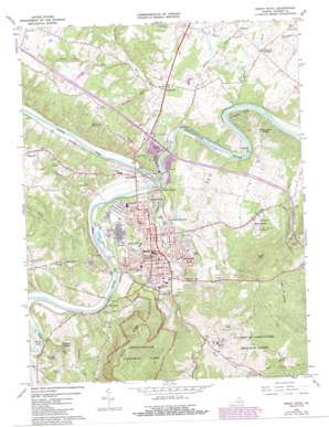
Front Royal Topo Map Virginia
To zoom in, hover over the map of Front Royal
USGS Topo Quad 38078h2 - 1:24,000 scale
| Topo Map Name: | Front Royal |
| USGS Topo Quad ID: | 38078h2 |
| Print Size: | ca. 21 1/4" wide x 27" high |
| Southeast Coordinates: | 38.875° N latitude / 78.125° W longitude |
| Map Center Coordinates: | 38.9375° N latitude / 78.1875° W longitude |
| U.S. State: | VA |
| Filename: | o38078h2.jpg |
| Download Map JPG Image: | Front Royal topo map 1:24,000 scale |
| Map Type: | Topographic |
| Topo Series: | 7.5´ |
| Map Scale: | 1:24,000 |
| Source of Map Images: | United States Geological Survey (USGS) |
| Alternate Map Versions: |
Front Royal VA 1967, updated 1968 Download PDF Buy paper map Front Royal VA 1967, updated 1973 Download PDF Buy paper map Front Royal VA 1967, updated 1978 Download PDF Buy paper map Front Royal VA 1967, updated 1987 Download PDF Buy paper map Front Royal VA 1972, updated 1974 Download PDF Buy paper map Front Royal VA 1994, updated 1997 Download PDF Buy paper map Front Royal VA 2010 Download PDF Buy paper map Front Royal VA 2013 Download PDF Buy paper map Front Royal VA 2016 Download PDF Buy paper map |
1:24,000 Topo Quads surrounding Front Royal
> Back to 38078e1 at 1:100,000 scale
> Back to 38078a1 at 1:250,000 scale
> Back to U.S. Topo Maps home
Front Royal topo map: Gazetteer
Front Royal: Bends
Horseshoe Bend elevation 158m 518′Front Royal: Bridges
Wilson J Burke Senior Memorial Bridge elevation 143m 469′Front Royal: Crossings
Interchange 6 elevation 165m 541′Front Royal: Dams
Cooley Dam elevation 191m 626′Lake Front Royal Dam elevation 293m 961′
Potomac-Edison Dam elevation 137m 449′
Warren Dam elevation 136m 446′
Front Royal: Flats
Chimney Field elevation 179m 587′Front Royal: Parks
Chimney Field Park elevation 179m 587′Crosby Stadium elevation 157m 515′
Ed Stump Playground elevation 167m 547′
Happy Creek Park elevation 189m 620′
Lions Park elevation 153m 501′
Warren County Environmental Study Area elevation 305m 1000′
Front Royal: Populated Places
Belmont elevation 193m 633′Ben Mar elevation 196m 643′
Benny Megeath elevation 164m 538′
Cedarville elevation 160m 524′
Colonial Park elevation 210m 688′
Country Club View elevation 179m 587′
Deer Haven elevation 255m 836′
Downing (historical) elevation 257m 843′
Dungadin Heights elevation 224m 734′
Elwood Acres elevation 233m 764′
Front Royal elevation 173m 567′
Front Royal Junction elevation 158m 518′
Grandview Estates elevation 199m 652′
Green Hill Forest elevation 307m 1007′
Happy Creek elevation 196m 643′
Hensel Stone Woods elevation 163m 534′
Heritage elevation 246m 807′
Highland Park elevation 196m 643′
Hill and Dale elevation 165m 541′
Kemp Park elevation 169m 554′
McCoy elevation 192m 629′
Merrymount elevation 195m 639′
Mineral Springs elevation 202m 662′
Mountain View elevation 205m 672′
River View elevation 185m 606′
Riverside elevation 172m 564′
Riverton elevation 160m 524′
Riverton Junction elevation 157m 515′
Rockland elevation 176m 577′
Royal Village elevation 158m 518′
Sans Facon elevation 300m 984′
Shenandoah River Estates elevation 147m 482′
Shenandoah Shores elevation 170m 557′
Success elevation 183m 600′
The Lions Den elevation 189m 620′
Vaught Estates elevation 176m 577′
Viscose City elevation 170m 557′
Warren Park elevation 176m 577′
Williamsburg Estates elevation 209m 685′
Woodland Park elevation 204m 669′
Front Royal: Post Offices
Front Royal Post Office elevation 175m 574′Riverton Post Office elevation 149m 488′
Front Royal: Rapids
Kings Eddy elevation 149m 488′Front Royal: Reservoirs
Cooley Lake elevation 191m 626′Lake Front Royal elevation 293m 961′
Warren Reservoir elevation 136m 446′
Front Royal: Streams
Cabin Run elevation 141m 462′Crooked Run elevation 138m 452′
Dry Run elevation 149m 488′
Happy Creek elevation 142m 465′
Leach Run elevation 146m 479′
Molly Camel Run elevation 151m 495′
North Fork Shenandoah River elevation 138m 452′
Punches Run elevation 141m 462′
Ritenour Run elevation 147m 482′
Sheep Run elevation 156m 511′
Sloan Creek elevation 230m 754′
South Fork Shenandoah River elevation 138m 452′
West Run elevation 147m 482′
Willow Brook elevation 135m 442′
Front Royal: Summits
Catlett Mountain elevation 254m 833′Edge Hill elevation 192m 629′
Green Hill elevation 388m 1272′
Guard Hill elevation 203m 666′
Front Royal: Valleys
Bear Hollow elevation 297m 974′Dismal Hollow elevation 181m 593′
Toney Hollow elevation 158m 518′
Valley of Retreat elevation 234m 767′
Front Royal digital topo map on disk
Buy this Front Royal topo map showing relief, roads, GPS coordinates and other geographical features, as a high-resolution digital map file on DVD:
Western Virginia & Southern West Virginia
Buy digital topo maps: Western Virginia & Southern West Virginia


