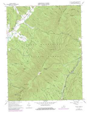
Elliott Knob Topo Map Virginia
To zoom in, hover over the map of Elliott Knob
USGS Topo Quad 38079b3 - 1:24,000 scale
| Topo Map Name: | Elliott Knob |
| USGS Topo Quad ID: | 38079b3 |
| Print Size: | ca. 21 1/4" wide x 27" high |
| Southeast Coordinates: | 38.125° N latitude / 79.25° W longitude |
| Map Center Coordinates: | 38.1875° N latitude / 79.3125° W longitude |
| U.S. State: | VA |
| Filename: | o38079b3.jpg |
| Download Map JPG Image: | Elliott Knob topo map 1:24,000 scale |
| Map Type: | Topographic |
| Topo Series: | 7.5´ |
| Map Scale: | 1:24,000 |
| Source of Map Images: | United States Geological Survey (USGS) |
| Alternate Map Versions: |
Elliott Knob VA 1967, updated 1968 Download PDF Buy paper map Elliott Knob VA 1967, updated 1978 Download PDF Buy paper map Elliott Knob VA 1999, updated 2001 Download PDF Buy paper map Elliott Knob VA 2011 Download PDF Buy paper map Elliott Knob VA 2013 Download PDF Buy paper map Elliott Knob VA 2016 Download PDF Buy paper map |
| FStopo: | US Forest Service topo Elliott Knob is available: Download FStopo PDF Download FStopo TIF |
1:24,000 Topo Quads surrounding Elliott Knob
> Back to 38079a1 at 1:100,000 scale
> Back to 38078a1 at 1:250,000 scale
> Back to U.S. Topo Maps home
Elliott Knob topo map: Gazetteer
Elliott Knob: Gaps
Dry Branch Gap elevation 787m 2582′Kings Gap elevation 779m 2555′
Elliott Knob: Populated Places
Chapin elevation 622m 2040′Mount Elliott Springs elevation 573m 1879′
North Mountain elevation 629m 2063′
Elliott Knob: Post Offices
Mount Elliott Post Office (historical) elevation 573m 1879′Elliott Knob: Ridges
Lead-Off Ridge elevation 1103m 3618′Elliott Knob: Springs
Buffalo Spring elevation 1045m 3428′Chestnut Flat Spring elevation 1087m 3566′
Cold Spring elevation 768m 2519′
Red Oak Spring elevation 1070m 3510′
Elliott Knob: Streams
Charlie Lick Branch elevation 524m 1719′Elliott Springs Run elevation 556m 1824′
Fall Branch elevation 667m 2188′
Laurel Branch elevation 545m 1788′
Rock Lick elevation 558m 1830′
South Fork White Rock Branch elevation 570m 1870′
Stony Lick elevation 554m 1817′
West Dry Branch elevation 538m 1765′
White Rock Branch elevation 524m 1719′
Elliott Knob: Summits
Crawford Knob elevation 1136m 3727′Crawford Mountain elevation 1141m 3743′
Elliott Knob elevation 1354m 4442′
Great North Mountain elevation 1358m 4455′
Haycock Knob elevation 860m 2821′
Hogback elevation 1355m 4445′
Elliott Knob: Trails
Chimney Hollow Trail elevation 840m 2755′Crawford Knob Trail elevation 1053m 3454′
Elliott Knob Trail elevation 1140m 3740′
Little North Mountain Trail elevation 901m 2956′
Shillings Trail elevation 855m 2805′
Trimbles Mill Trail elevation 657m 2155′
Elliott Knob: Valleys
Alier Hollow elevation 546m 1791′Baker Draft elevation 558m 1830′
Chapin Draft elevation 606m 1988′
Falls Hollow elevation 573m 1879′
Hodges Draft elevation 556m 1824′
Left Fork Tims Draft elevation 557m 1827′
Madison Hollow elevation 548m 1797′
Ramseys Draft elevation 564m 1850′
Reubens Draft elevation 531m 1742′
Right Fork Tims Draft elevation 556m 1824′
Steel Lick Draft elevation 588m 1929′
Wolfpen Draft elevation 571m 1873′
Wood Draft elevation 560m 1837′
Elliott Knob digital topo map on disk
Buy this Elliott Knob topo map showing relief, roads, GPS coordinates and other geographical features, as a high-resolution digital map file on DVD:
Western Virginia & Southern West Virginia
Buy digital topo maps: Western Virginia & Southern West Virginia


