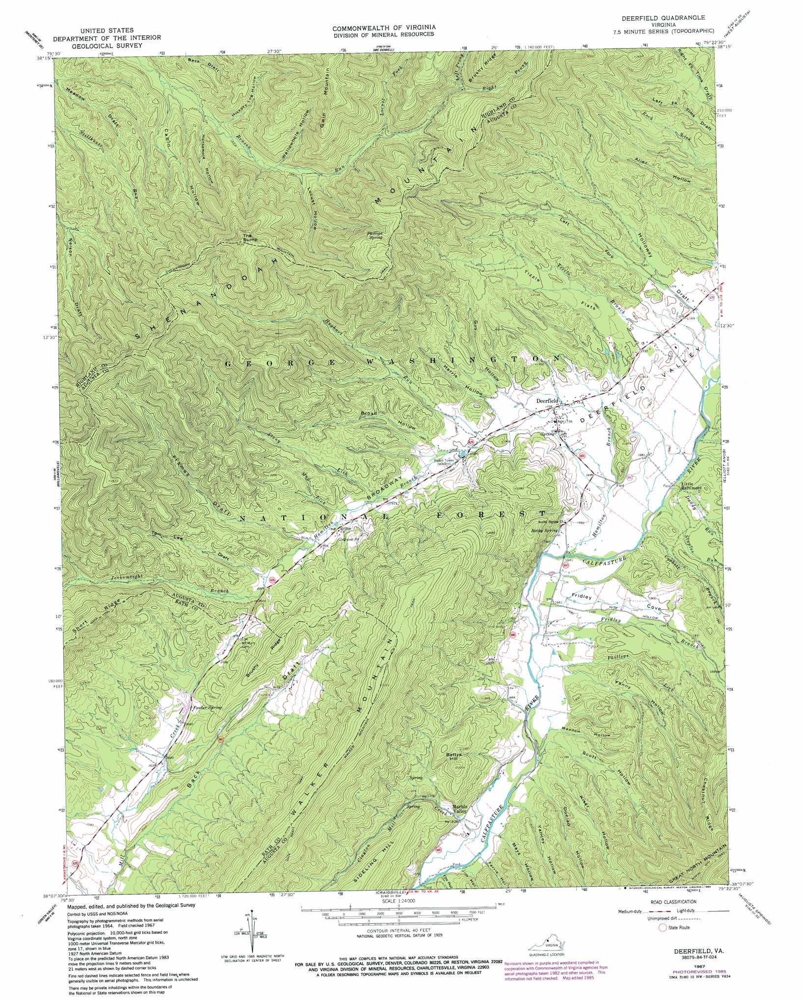
Deerfield Topo Map Virginia
To zoom in, hover over the map of Deerfield
USGS Topo Quad 38079b4 - 1:24,000 scale
| Topo Map Name: | Deerfield |
| USGS Topo Quad ID: | 38079b4 |
| Print Size: | ca. 21 1/4" wide x 27" high |
| Southeast Coordinates: | 38.125° N latitude / 79.375° W longitude |
| Map Center Coordinates: | 38.1875° N latitude / 79.4375° W longitude |
| U.S. State: | VA |
| Filename: | o38079b4.jpg |
| Download Map JPG Image: | Deerfield topo map 1:24,000 scale |
| Map Type: | Topographic |
| Topo Series: | 7.5´ |
| Map Scale: | 1:24,000 |
| Source of Map Images: | United States Geological Survey (USGS) |
| Alternate Map Versions: |
Deerfield VA 1967, updated 1968 Download PDF Buy paper map Deerfield VA 1967, updated 1980 Download PDF Buy paper map Deerfield VA 1967, updated 1985 Download PDF Buy paper map Deerfield VA 1967, updated 1985 Download PDF Buy paper map Deerfield VA 2011 Download PDF Buy paper map Deerfield VA 2013 Download PDF Buy paper map Deerfield VA 2016 Download PDF Buy paper map |
| FStopo: | US Forest Service topo Deerfield is available: Download FStopo PDF Download FStopo TIF |
1:24,000 Topo Quads surrounding Deerfield
Hightown |
Monterey |
Doe Hill |
Palo Alto |
Reddish Knob |
Mustoe |
Monterey Se |
Mcdowell |
West Augusta |
Stokesville |
Burnsville |
Williamsville |
Deerfield |
Elliott Knob |
Churchville |
Bath Alum |
Green Valley |
Craigsville |
Augusta Springs |
Greenville |
Nimrod Hall |
Millboro |
Goshen |
Brownsburg |
Vesuvius |
> Back to 38079a1 at 1:100,000 scale
> Back to 38078a1 at 1:250,000 scale
> Back to U.S. Topo Maps home
Deerfield topo map: Gazetteer
Deerfield: Flats
Broadway elevation 546m 1791′Tizzle Flats elevation 593m 1945′
Deerfield: Populated Places
Deerfield elevation 530m 1738′Little Baltimore elevation 516m 1692′
Marble Valley elevation 497m 1630′
Deerfield: Ranges
Walker Mountain elevation 981m 3218′Deerfield: Ridges
Brushy Ridge elevation 776m 2545′Chestnut Ridge elevation 842m 2762′
Deerfield: Springs
Fowler Spring elevation 631m 2070′Phillips Spring elevation 979m 3211′
Rocky Spring elevation 510m 1673′
Deerfield: Streams
Clayton Mill Creek elevation 478m 1568′Corbett Branch elevation 506m 1660′
Daddy Run elevation 507m 1663′
Fridley Branch elevation 493m 1617′
Hamilton Branch elevation 498m 1633′
Hughart Run elevation 545m 1788′
Jerkemtight Branch elevation 593m 1945′
Left Fork elevation 544m 1784′
Left Prong Benson Run elevation 821m 2693′
Locust Fork elevation 724m 2375′
Mud Lick elevation 580m 1902′
Phillips Lick elevation 490m 1607′
Right Prong Benson Run elevation 815m 2673′
Staples Run elevation 505m 1656′
Still Run elevation 512m 1679′
Stony Lick elevation 572m 1876′
Tizzle Branch elevation 519m 1702′
Deerfield: Summits
Bettys Hill elevation 674m 2211′The Bump elevation 1099m 3605′
Deerfield: Trails
Benson Run Trail elevation 625m 2050′North Mountain Trail elevation 993m 3257′
Shenandoah Mountain Trail elevation 980m 3215′
Deerfield: Valleys
Back Draft elevation 609m 1998′Broad Hollow elevation 556m 1824′
Cabin Hollow elevation 595m 1952′
Deerfield Valley elevation 498m 1633′
Dunlap Hollow elevation 492m 1614′
Fanny Hollow elevation 498m 1633′
Ferris Hollow elevation 487m 1597′
Fox Hollow elevation 487m 1597′
Frames Draft elevation 595m 1952′
Fridley Cove elevation 508m 1666′
Guy Hollow elevation 546m 1791′
Harris Hollow elevation 547m 1794′
Hickory Log Hollow elevation 620m 2034′
Holloway Draft elevation 524m 1719′
Horsehole Hollow elevation 609m 1998′
Jim Hollow elevation 482m 1581′
Kiser Hollow elevation 492m 1614′
Left Fork Holloway Draft elevation 543m 1781′
Locust Hollow elevation 659m 2162′
Mays Hollow elevation 482m 1581′
Meadow Hollow elevation 493m 1617′
Scott Hollow elevation 487m 1597′
Tims Draft elevation 521m 1709′
Tom Lee Draft elevation 616m 2020′
Wallowhole Hollow elevation 660m 2165′
Yancey Hollow elevation 489m 1604′
Deerfield digital topo map on disk
Buy this Deerfield topo map showing relief, roads, GPS coordinates and other geographical features, as a high-resolution digital map file on DVD:
Western Virginia & Southern West Virginia
Buy digital topo maps: Western Virginia & Southern West Virginia