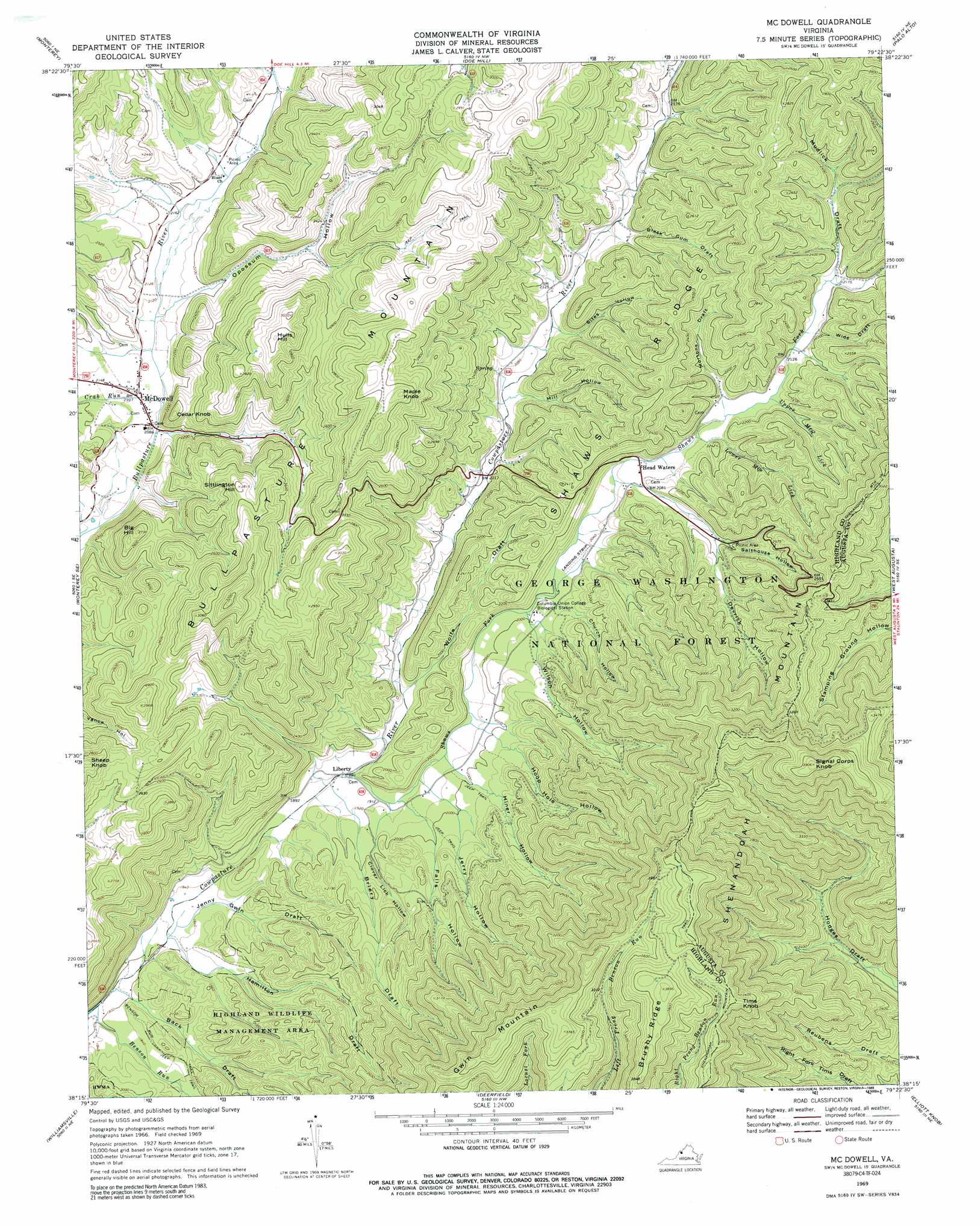
Mcdowell Topo Map Virginia
To zoom in, hover over the map of Mcdowell
USGS Topo Quad 38079c4 - 1:24,000 scale
| Topo Map Name: | Mcdowell |
| USGS Topo Quad ID: | 38079c4 |
| Print Size: | ca. 21 1/4" wide x 27" high |
| Southeast Coordinates: | 38.25° N latitude / 79.375° W longitude |
| Map Center Coordinates: | 38.3125° N latitude / 79.4375° W longitude |
| U.S. State: | VA |
| Filename: | o38079c4.jpg |
| Download Map JPG Image: | Mcdowell topo map 1:24,000 scale |
| Map Type: | Topographic |
| Topo Series: | 7.5´ |
| Map Scale: | 1:24,000 |
| Source of Map Images: | United States Geological Survey (USGS) |
| Alternate Map Versions: |
Mc Dowell VA 1969, updated 1971 Download PDF Buy paper map Mc Dowell VA 1969, updated 1989 Download PDF Buy paper map Mc Dowell VA 1999, updated 2001 Download PDF Buy paper map McDowell VA 2011 Download PDF Buy paper map McDowell VA 2013 Download PDF Buy paper map McDowell VA 2016 Download PDF Buy paper map |
| FStopo: | US Forest Service topo McDowell is available: Download FStopo PDF Download FStopo TIF |
1:24,000 Topo Quads surrounding Mcdowell
Thornwood |
Snowy Mountain |
Moatstown |
Sugar Grove |
Brandywine |
Hightown |
Monterey |
Doe Hill |
Palo Alto |
Reddish Knob |
Mustoe |
Monterey Se |
Mcdowell |
West Augusta |
Stokesville |
Burnsville |
Williamsville |
Deerfield |
Elliott Knob |
Churchville |
Bath Alum |
Green Valley |
Craigsville |
Augusta Springs |
Greenville |
> Back to 38079a1 at 1:100,000 scale
> Back to 38078a1 at 1:250,000 scale
> Back to U.S. Topo Maps home
Mcdowell topo map: Gazetteer
Mcdowell: Populated Places
Liberty elevation 574m 1883′McDowell elevation 643m 2109′
Mcdowell: Streams
Benson Run elevation 546m 1791′Crab Run elevation 633m 2076′
Lower Mountain Lick elevation 632m 2073′
Shaws Fork elevation 574m 1883′
Upper Mountain Lick elevation 641m 2103′
Mcdowell: Summits
Big Hill elevation 820m 2690′Brushy Ridge elevation 1185m 3887′
Cedar Knob elevation 758m 2486′
Gwin Mountain elevation 1149m 3769′
Hulls Hill elevation 927m 3041′
Maple Knob elevation 950m 3116′
Sheep Knob elevation 903m 2962′
Signal Corps Knob elevation 1187m 3894′
Sittlington Hill elevation 857m 2811′
Tims Knob elevation 1088m 3569′
Mcdowell: Valleys
Back Draft elevation 546m 1791′Black Gum Draft elevation 636m 2086′
Briery Draft elevation 573m 1879′
Church Hollow elevation 607m 1991′
Clover Lick Hollow elevation 600m 1968′
Devrick Hollow elevation 662m 2171′
Falls Hollow elevation 606m 1988′
Hamilton Draft elevation 550m 1804′
Hiner Hollow elevation 622m 2040′
Hoop Hole Hollow elevation 632m 2073′
Jenny Gwin Draft elevation 549m 1801′
Jerry Hollow elevation 609m 1998′
Mill Hollow elevation 612m 2007′
Mortons Draft elevation 636m 2086′
Mudlick Draft elevation 656m 2152′
Opossum Hollow elevation 662m 2171′
Phillips Hollow elevation 680m 2230′
Salthouse Hollow elevation 662m 2171′
Sites Hollow elevation 621m 2037′
Wide Draft elevation 651m 2135′
Wilson Hollow elevation 605m 1984′
Wolfe Draft elevation 584m 1916′
Mcdowell digital topo map on disk
Buy this Mcdowell topo map showing relief, roads, GPS coordinates and other geographical features, as a high-resolution digital map file on DVD:
Western Virginia & Southern West Virginia
Buy digital topo maps: Western Virginia & Southern West Virginia