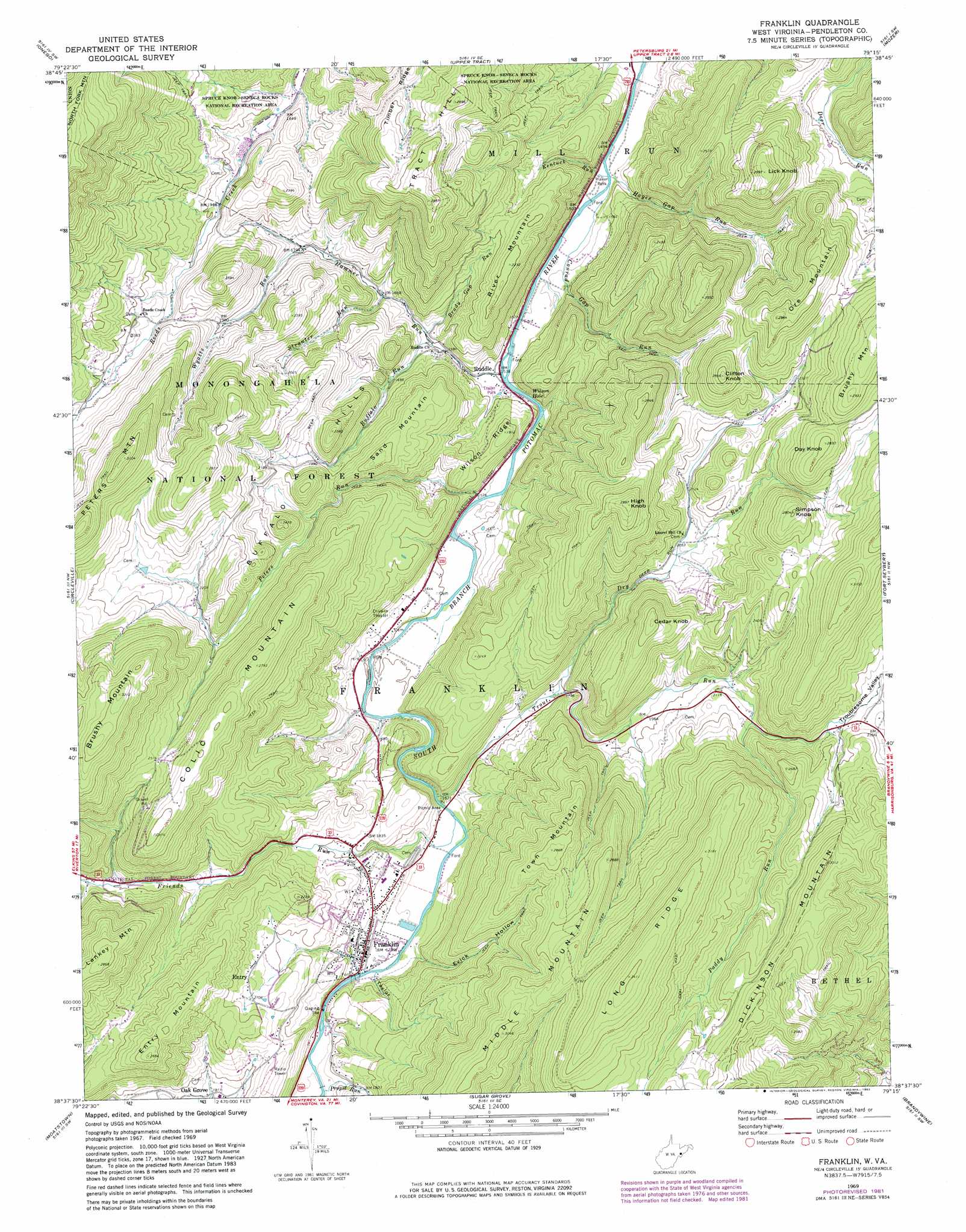
Franklin Topo Map West Virginia
To zoom in, hover over the map of Franklin
USGS Topo Quad 38079f3 - 1:24,000 scale
| Topo Map Name: | Franklin |
| USGS Topo Quad ID: | 38079f3 |
| Print Size: | ca. 21 1/4" wide x 27" high |
| Southeast Coordinates: | 38.625° N latitude / 79.25° W longitude |
| Map Center Coordinates: | 38.6875° N latitude / 79.3125° W longitude |
| U.S. State: | WV |
| Filename: | o38079f3.jpg |
| Download Map JPG Image: | Franklin topo map 1:24,000 scale |
| Map Type: | Topographic |
| Topo Series: | 7.5´ |
| Map Scale: | 1:24,000 |
| Source of Map Images: | United States Geological Survey (USGS) |
| Alternate Map Versions: |
Franklin WV 1969, updated 1973 Download PDF Buy paper map Franklin WV 1969, updated 1977 Download PDF Buy paper map Franklin WV 1969, updated 1982 Download PDF Buy paper map Franklin WV 1995, updated 1998 Download PDF Buy paper map Franklin WV 2011 Download PDF Buy paper map Franklin WV 2014 Download PDF Buy paper map Franklin WV 2016 Download PDF Buy paper map |
| FStopo: | US Forest Service topo Franklin is available: Download FStopo PDF Download FStopo TIF |
1:24,000 Topo Quads surrounding Franklin
Harman |
Laneville |
Hopeville |
Petersburg West |
Petersburg East |
Whitmer |
Onego |
Upper Tract |
Mozer |
Milam |
Spruce Knob |
Circleville |
Franklin |
Fort Seybert |
Cow Knob |
Snowy Mountain |
Moatstown |
Sugar Grove |
Brandywine |
Rawley Springs |
Monterey |
Doe Hill |
Palo Alto |
Reddish Knob |
Briery Branch |
> Back to 38079e1 at 1:100,000 scale
> Back to 38078a1 at 1:250,000 scale
> Back to U.S. Topo Maps home
Franklin topo map: Gazetteer
Franklin: Bays
Wilson Hole elevation 465m 1525′Franklin: Populated Places
Entry elevation 631m 2070′Franklin elevation 528m 1732′
Oak Grove elevation 582m 1909′
Ruddle elevation 469m 1538′
Franklin: Ridges
Long Ridge elevation 1031m 3382′Wilson Ridge elevation 555m 1820′
Franklin: Springs
Allen Eye Spring elevation 697m 2286′Big Spring elevation 583m 1912′
Hammer Spring elevation 480m 1574′
Reeds Creek Spring elevation 586m 1922′
Smith Farm Spring elevation 573m 1879′
Wilson Spring elevation 490m 1607′
Franklin: Streams
Brady Gap Run elevation 489m 1604′Buffalo Run elevation 485m 1591′
Conrad Gap Run elevation 455m 1492′
Dry Run elevation 544m 1784′
Friends Run elevation 503m 1650′
Hammer Run elevation 469m 1538′
Hayes Gap Run elevation 454m 1489′
Kentuck Run elevation 456m 1496′
Paddy Run elevation 651m 2135′
Peters Run elevation 476m 1561′
Propst Run elevation 525m 1722′
Strauter Run elevation 506m 1660′
Trout Run elevation 500m 1640′
Wyatts Run elevation 547m 1794′
Franklin: Summits
Brushy Mountain elevation 1004m 3293′Buffalo Hills elevation 732m 2401′
Cedar Knob elevation 815m 2673′
Clifton Knob elevation 866m 2841′
Colic Mountain elevation 858m 2814′
Day Knob elevation 858m 2814′
Entry Mountain elevation 813m 2667′
High Knob elevation 912m 2992′
Lankey Mountain elevation 872m 2860′
Lick Knob elevation 905m 2969′
Middle Mountain elevation 924m 3031′
Ore Mountain elevation 886m 2906′
River Mountain elevation 675m 2214′
Sand Mountain elevation 691m 2267′
Simpson Knob elevation 849m 2785′
Town Mountain elevation 872m 2860′
Tract Hill elevation 884m 2900′
Franklin: Valleys
Evick Hollow elevation 534m 1751′Taylor Hollow elevation 526m 1725′
Troublesome Valley elevation 689m 2260′
Franklin digital topo map on disk
Buy this Franklin topo map showing relief, roads, GPS coordinates and other geographical features, as a high-resolution digital map file on DVD:
Western Virginia & Southern West Virginia
Buy digital topo maps: Western Virginia & Southern West Virginia