Spruce Knob Topo Map West Virginia
To zoom in, hover over the map of Spruce Knob
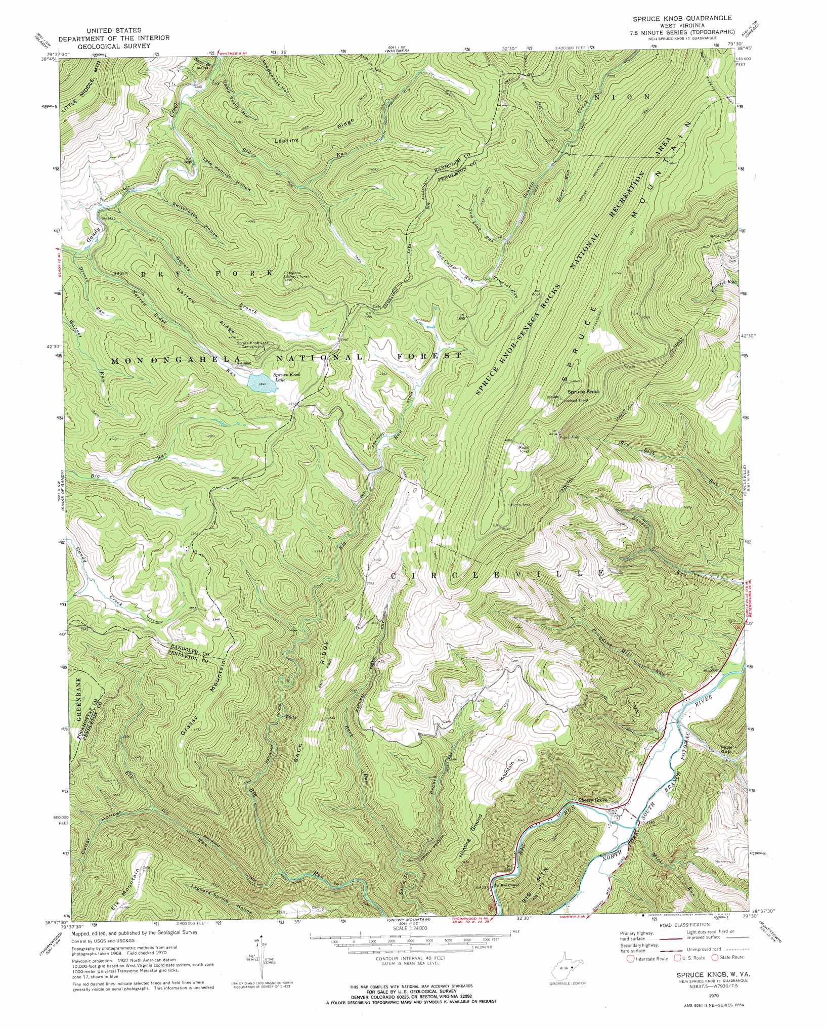
USGS Topo Quad 38079f5 - 1:24,000 scale
| Topo Map Name: | Spruce Knob |
| USGS Topo Quad ID: | 38079f5 |
| Print Size: | ca. 21 1/4" wide x 27" high |
| Southeast Coordinates: | 38.625° N latitude / 79.5° W longitude |
| Map Center Coordinates: | 38.6875° N latitude / 79.5625° W longitude |
| U.S. State: | WV |
| Filename: | o38079f5.jpg |
| Download Map JPG Image: | Spruce Knob topo map 1:24,000 scale |
| Map Type: | Topographic |
| Topo Series: | 7.5´ |
| Map Scale: | 1:24,000 |
| Source of Map Images: | United States Geological Survey (USGS) |
| Alternate Map Versions: |
Spruce Knob WV 1970, updated 1973 Download PDF Buy paper map Spruce Knob WV 1995, updated 1998 Download PDF Buy paper map Spruce Knob WV 2011 Download PDF Buy paper map Spruce Knob WV 2014 Download PDF Buy paper map Spruce Knob WV 2016 Download PDF Buy paper map |
| FStopo: | US Forest Service topo Spruce Knob is available: Download FStopo PDF Download FStopo TIF |
1:24,000 Topo Quads surrounding Spruce Knob
Elkins |
Bowden |
Harman |
Laneville |
Hopeville |
Beverly East |
Glady |
Whitmer |
Onego |
Upper Tract |
Wildell |
Sinks Of Gandy |
Spruce Knob |
Circleville |
Franklin |
Durbin |
Thornwood |
Snowy Mountain |
Moatstown |
Sugar Grove |
Green Bank |
Hightown |
Monterey |
Doe Hill |
Palo Alto |
> Back to 38079e1 at 1:100,000 scale
> Back to 38078a1 at 1:250,000 scale
> Back to U.S. Topo Maps home
Spruce Knob topo map: Gazetteer
Spruce Knob: Dams
Spruce Knob Lake Dam elevation 1172m 3845′Spruce Knob: Gaps
Teter Gap elevation 680m 2230′Spruce Knob: Populated Places
Cherry Grove elevation 671m 2201′Spruce Knob: Ranges
Allegheny Mountains elevation 1482m 4862′Spruce Knob: Reservoirs
Spruce Knob Lake elevation 1171m 3841′Spruce Knob: Ridges
Back Ridge elevation 1145m 3756′Leading Ridge elevation 1232m 4041′
Narrow Ridge elevation 1243m 4078′
Spruce Knob: Springs
Big Spring elevation 1082m 3549′Judy Spring elevation 1152m 3779′
Spruce Mountain Spring elevation 1362m 4468′
Spruce Knob: Streams
Back Run elevation 833m 2732′Beech Run elevation 1087m 3566′
Big Run elevation 993m 3257′
Big Run elevation 734m 2408′
Devers Run elevation 1046m 3431′
Elk Run elevation 823m 2700′
Grants Branch elevation 1026m 3366′
Mick Run elevation 665m 2181′
Nans Branch elevation 983m 3225′
Narrow Ridge elevation 1043m 3421′
Pounding Mill Run elevation 646m 2119′
Slab Camp Run elevation 1149m 3769′
Teter Run elevation 650m 2132′
Tom Lick Run elevation 1130m 3707′
Trussel Run elevation 1142m 3746′
Spruce Knob: Summits
Elk Mountain elevation 1273m 4176′Grassy Mountain elevation 1265m 4150′
Hunting Ground Mountain elevation 1106m 3628′
Spruce Knob elevation 1482m 4862′
Spruce Mountain elevation 1482m 4862′
Spruce Knob: Trails
Back Ridge Trail elevation 1131m 3710′Big Run Trail elevation 1068m 3503′
Gatewood Nature Trail elevation 1149m 3769′
Horton Riverton Trail elevation 1331m 4366′
Huckleberry Trail elevation 1423m 4668′
North Fork Big Run Trail elevation 1145m 3756′
Spruce Knob: Valleys
Camp Seven Hollow elevation 996m 3267′Collar Hollow elevation 947m 3106′
Lafe Hedrick Hollow elevation 1014m 3326′
Switchback Hollow elevation 1026m 3366′
Spruce Knob digital topo map on disk
Buy this Spruce Knob topo map showing relief, roads, GPS coordinates and other geographical features, as a high-resolution digital map file on DVD:
Western Virginia & Southern West Virginia
Buy digital topo maps: Western Virginia & Southern West Virginia