Sinks Of Gandy Topo Map West Virginia
To zoom in, hover over the map of Sinks Of Gandy
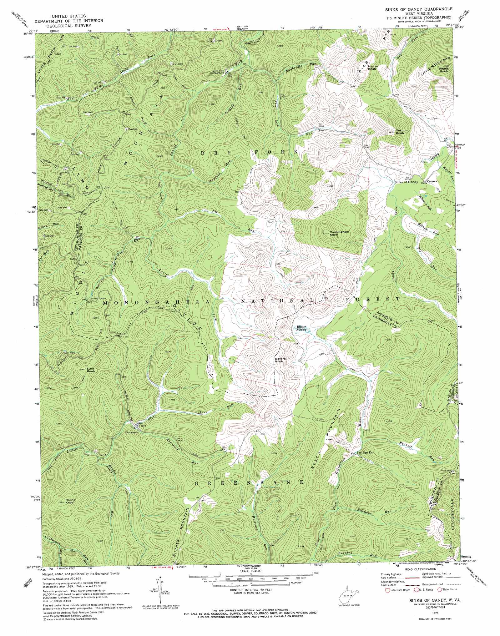
USGS Topo Quad 38079f6 - 1:24,000 scale
| Topo Map Name: | Sinks Of Gandy |
| USGS Topo Quad ID: | 38079f6 |
| Print Size: | ca. 21 1/4" wide x 27" high |
| Southeast Coordinates: | 38.625° N latitude / 79.625° W longitude |
| Map Center Coordinates: | 38.6875° N latitude / 79.6875° W longitude |
| U.S. State: | WV |
| Filename: | o38079f6.jpg |
| Download Map JPG Image: | Sinks Of Gandy topo map 1:24,000 scale |
| Map Type: | Topographic |
| Topo Series: | 7.5´ |
| Map Scale: | 1:24,000 |
| Source of Map Images: | United States Geological Survey (USGS) |
| Alternate Map Versions: |
Sinks of Gandy WV 1970, updated 1973 Download PDF Buy paper map Sinks Of Gandy WV 1970, updated 1989 Download PDF Buy paper map Sinks of Gandy WV 1995, updated 1998 Download PDF Buy paper map Sinks of Gandy WV 2011 Download PDF Buy paper map Sinks of Gandy WV 2014 Download PDF Buy paper map Sinks of Gandy WV 2016 Download PDF Buy paper map |
| FStopo: | US Forest Service topo Sinks of Gandy is available: Download FStopo PDF Download FStopo TIF |
1:24,000 Topo Quads surrounding Sinks Of Gandy
Junior |
Elkins |
Bowden |
Harman |
Laneville |
Beverly West |
Beverly East |
Glady |
Whitmer |
Onego |
Mill Creek |
Wildell |
Sinks Of Gandy |
Spruce Knob |
Circleville |
Snyder Knob |
Durbin |
Thornwood |
Snowy Mountain |
Moatstown |
Cass |
Green Bank |
Hightown |
Monterey |
Doe Hill |
> Back to 38079e1 at 1:100,000 scale
> Back to 38078a1 at 1:250,000 scale
> Back to U.S. Topo Maps home
Sinks Of Gandy topo map: Gazetteer
Sinks Of Gandy: Basins
Sinks of Gandy elevation 1059m 3474′Sinks Of Gandy: Populated Places
Osceola elevation 1075m 3526′Sinks Of Gandy: Ridges
Lynn Divide elevation 1200m 3937′Sinks Of Gandy: Streams
Bennett Run elevation 1077m 3533′Big Run elevation 1068m 3503′
Burning Run elevation 1026m 3366′
Camp Five Run elevation 1026m 3366′
Crawford Run elevation 988m 3241′
Elk Run elevation 1015m 3330′
Elklick Run elevation 970m 3182′
Five Lick Run elevation 939m 3080′
Hansford Run elevation 1000m 3280′
Hinkle Run elevation 983m 3225′
Lukins Run elevation 1008m 3307′
Simmons Run elevation 1053m 3454′
Stillhouse Run elevation 1070m 3510′
Stoney Run elevation 1071m 3513′
Tingler Run elevation 943m 3093′
Warner Run elevation 1055m 3461′
Waybright Run elevation 953m 3126′
Sinks Of Gandy: Summits
Bayard Knob elevation 1263m 4143′Beech Mountain elevation 1237m 4058′
Cunningham Knob elevation 1339m 4393′
Harper Knob elevation 1269m 4163′
Little Middle Mountain elevation 1423m 4668′
Lynn Knob elevation 1213m 3979′
Pharis Knob elevation 1413m 4635′
Round Knob elevation 1202m 3943′
Yokum Knob elevation 1301m 4268′
Sinks Of Gandy: Swamps
Blister Swamp elevation 1105m 3625′Sinks Of Gandy: Trails
Beulah Trail elevation 1006m 3300′Camp Five Trail elevation 1073m 3520′
Chaffey Trail elevation 1093m 3585′
County Line Trail elevation 1072m 3517′
Forks Trail elevation 1002m 3287′
Hinkle Run Trail elevation 1004m 3293′
Lynn Knob Trail elevation 1182m 3877′
Tingler Trail elevation 1070m 3510′
Sinks Of Gandy digital topo map on disk
Buy this Sinks Of Gandy topo map showing relief, roads, GPS coordinates and other geographical features, as a high-resolution digital map file on DVD:
Western Virginia & Southern West Virginia
Buy digital topo maps: Western Virginia & Southern West Virginia