Laneville Topo Map West Virginia
To zoom in, hover over the map of Laneville
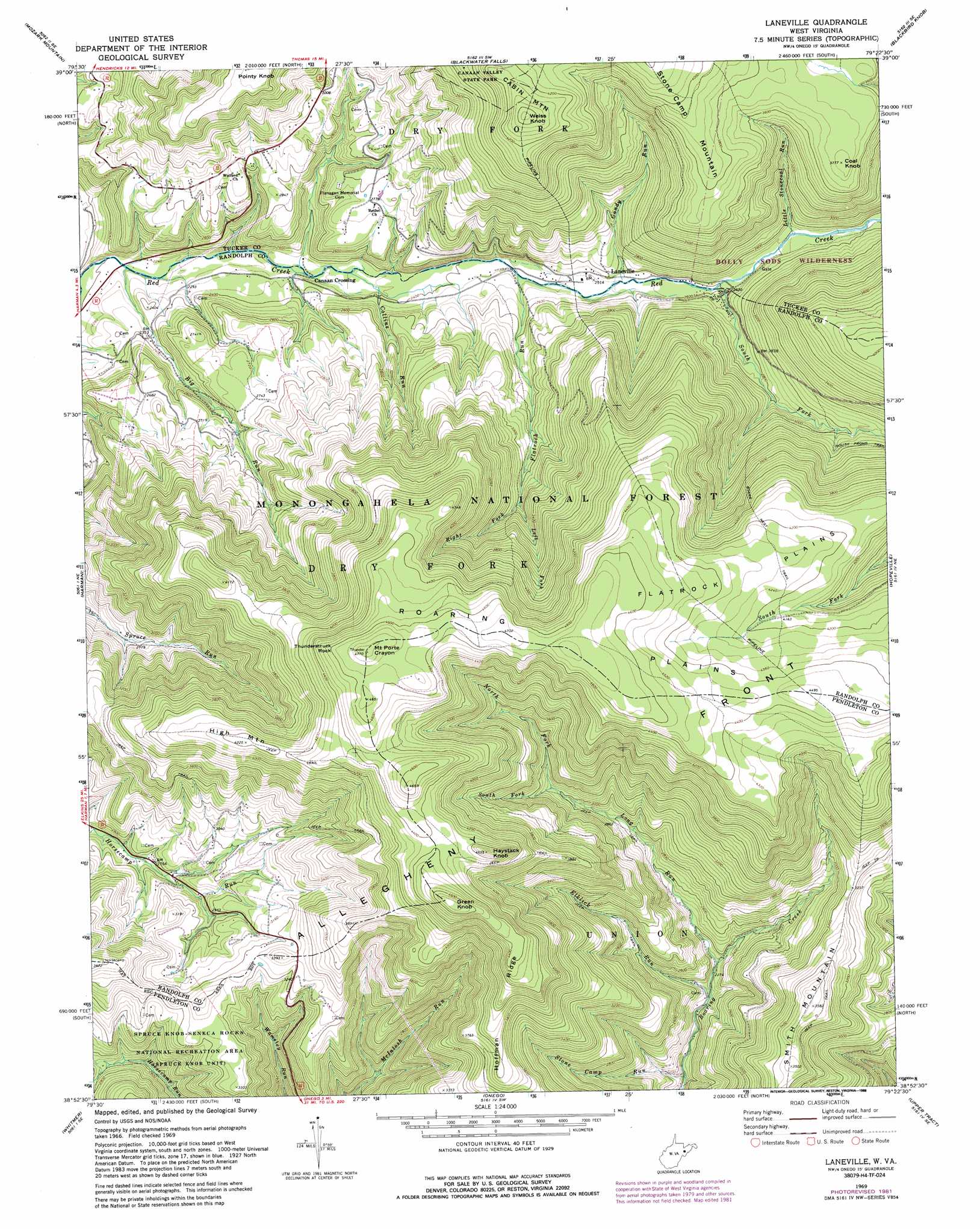
USGS Topo Quad 38079h4 - 1:24,000 scale
| Topo Map Name: | Laneville |
| USGS Topo Quad ID: | 38079h4 |
| Print Size: | ca. 21 1/4" wide x 27" high |
| Southeast Coordinates: | 38.875° N latitude / 79.375° W longitude |
| Map Center Coordinates: | 38.9375° N latitude / 79.4375° W longitude |
| U.S. State: | WV |
| Filename: | o38079h4.jpg |
| Download Map JPG Image: | Laneville topo map 1:24,000 scale |
| Map Type: | Topographic |
| Topo Series: | 7.5´ |
| Map Scale: | 1:24,000 |
| Source of Map Images: | United States Geological Survey (USGS) |
| Alternate Map Versions: |
Laneville WV 1969, updated 1973 Download PDF Buy paper map Laneville WV 1969, updated 1982 Download PDF Buy paper map Laneville WV 1969, updated 1988 Download PDF Buy paper map Laneville WV 1995, updated 1998 Download PDF Buy paper map Laneville WV 2011 Download PDF Buy paper map Laneville WV 2014 Download PDF Buy paper map Laneville WV 2016 Download PDF Buy paper map |
| FStopo: | US Forest Service topo Laneville is available: Download FStopo PDF Download FStopo TIF |
1:24,000 Topo Quads surrounding Laneville
Saint George |
Lead Mine |
Davis |
Mount Storm Lake |
Greenland Gap |
Parsons |
Mozark Mountain |
Blackwater Falls |
Blackbird Knob |
Maysville |
Bowden |
Harman |
Laneville |
Hopeville |
Petersburg West |
Glady |
Whitmer |
Onego |
Upper Tract |
Mozer |
Sinks Of Gandy |
Spruce Knob |
Circleville |
Franklin |
Fort Seybert |
> Back to 38079e1 at 1:100,000 scale
> Back to 38078a1 at 1:250,000 scale
> Back to U.S. Topo Maps home
Laneville topo map: Gazetteer
Laneville: Basins
Roaring Plains elevation 1441m 4727′Laneville: Flats
Flatrock Plains elevation 1315m 4314′Laneville: Pillars
Thunderstruck Rock elevation 1410m 4625′Laneville: Populated Places
Canaan Crossing elevation 705m 2312′Harperton elevation 860m 2821′
Laneville elevation 782m 2565′
Stringtown (historical) elevation 872m 2860′
Wyoming (historical) elevation 754m 2473′
Laneville: Ridges
Hoffman Ridge elevation 1253m 4110′Stone Camp Mountain elevation 1196m 3923′
Laneville: Springs
Addie Judy Spring elevation 769m 2522′Arbogast Farm Spring elevation 702m 2303′
Guy Harper Spring elevation 975m 3198′
Hartman Farm Spring elevation 764m 2506′
Hoyt Pennington Spring elevation 752m 2467′
Hoyt Pennington Spring elevation 799m 2621′
Lee Ullery Spring elevation 751m 2463′
Nelson Spring elevation 748m 2454′
Pennington Farm Spring elevation 761m 2496′
Snoden Yokum Spring elevation 884m 2900′
Snoden Yokum Spring elevation 847m 2778′
Wyatt Farm Spring elevation 878m 2880′
Laneville: Streams
Big Run elevation 677m 2221′Collins Run elevation 713m 2339′
Dolly Run elevation 809m 2654′
Elklick Run elevation 680m 2230′
Flatrock Run elevation 746m 2447′
Gandy Run elevation 772m 2532′
Left Fork Flatrock Creek elevation 940m 3083′
Little Stonecoal Run elevation 821m 2693′
Long Run elevation 702m 2303′
North Fork Long Run elevation 929m 3047′
Right Fork Flatrock Creek elevation 940m 3083′
South Fork Long Run elevation 929m 3047′
South Fork Red Creek elevation 791m 2595′
Stone Camp Run elevation 634m 2080′
Laneville: Summits
Coal Knob elevation 1148m 3766′Green Knob elevation 1424m 4671′
Haystack Knob elevation 1376m 4514′
High Mountain elevation 1287m 4222′
Mount Porte Crayon elevation 1452m 4763′
Smith Mountain elevation 1087m 3566′
Weiss Knob elevation 1359m 4458′
Laneville: Trails
Boars Nest Trail elevation 1200m 3937′Laneville digital topo map on disk
Buy this Laneville topo map showing relief, roads, GPS coordinates and other geographical features, as a high-resolution digital map file on DVD:
Western Virginia & Southern West Virginia
Buy digital topo maps: Western Virginia & Southern West Virginia