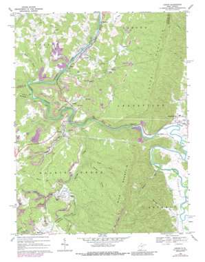
Junior Topo Map West Virginia
To zoom in, hover over the map of Junior
USGS Topo Quad 38079h8 - 1:24,000 scale
| Topo Map Name: | Junior |
| USGS Topo Quad ID: | 38079h8 |
| Print Size: | ca. 21 1/4" wide x 27" high |
| Southeast Coordinates: | 38.875° N latitude / 79.875° W longitude |
| Map Center Coordinates: | 38.9375° N latitude / 79.9375° W longitude |
| U.S. State: | WV |
| Filename: | o38079h8.jpg |
| Download Map JPG Image: | Junior topo map 1:24,000 scale |
| Map Type: | Topographic |
| Topo Series: | 7.5´ |
| Map Scale: | 1:24,000 |
| Source of Map Images: | United States Geological Survey (USGS) |
| Alternate Map Versions: |
Junior WV 1969, updated 1971 Download PDF Buy paper map Junior WV 1969, updated 1977 Download PDF Buy paper map Junior WV 1969, updated 1988 Download PDF Buy paper map Junior WV 2010 Download PDF Buy paper map Junior WV 2014 Download PDF Buy paper map Junior WV 2016 Download PDF Buy paper map |
1:24,000 Topo Quads surrounding Junior
> Back to 38079e1 at 1:100,000 scale
> Back to 38078a1 at 1:250,000 scale
> Back to U.S. Topo Maps home
Junior topo map: Gazetteer
Junior: Populated Places
Aggregates elevation 589m 1932′Bruxton elevation 595m 1952′
Coalton elevation 660m 2165′
Crystal Springs elevation 584m 1916′
Dartmoor elevation 531m 1742′
Findley (historical) elevation 591m 1938′
Fisher (historical) elevation 682m 2237′
Gage elevation 531m 1742′
Harding elevation 596m 1955′
Jeff Scotts (historical) elevation 621m 2037′
Junior elevation 532m 1745′
Laurel (historical) elevation 534m 1751′
Leiter (historical) elevation 559m 1833′
Mabie elevation 686m 2250′
Norton elevation 604m 1981′
Roaring Creek Junction elevation 569m 1866′
Skidmore (historical) elevation 538m 1765′
Tigheville elevation 596m 1955′
Weaver elevation 590m 1935′
West Junior elevation 532m 1745′
Junior: Post Offices
Mabie Post Office elevation 689m 2260′Norton Post Office elevation 570m 1870′
Junior: Springs
Denver Lee Shomer Spring elevation 583m 1912′Town of Junior Spring elevation 588m 1929′
Town of Junior Spring elevation 592m 1942′
Town of Junior Spring elevation 629m 2063′
Junior: Streams
Back Fork elevation 553m 1814′Beaver Creek elevation 527m 1729′
Big Laurel Run elevation 537m 1761′
Flatbush Fork elevation 679m 2227′
Grassy Fork elevation 579m 1899′
Grassy Run elevation 567m 1860′
Island Run elevation 527m 1729′
Laurel Run elevation 533m 1748′
Laurel Run elevation 677m 2221′
Laurel Run elevation 592m 1942′
Leading Creek elevation 578m 1896′
Little Laurel Run elevation 577m 1893′
Mathias Run elevation 580m 1902′
Roaring Creek elevation 569m 1866′
Whites Run elevation 654m 2145′
Whitman Run elevation 585m 1919′
Zebs Creek elevation 534m 1751′
Junior: Valleys
Broad Hollow elevation 635m 2083′Spring Hollow elevation 654m 2145′
Tygart Valley elevation 579m 1899′
Junior digital topo map on disk
Buy this Junior topo map showing relief, roads, GPS coordinates and other geographical features, as a high-resolution digital map file on DVD:
Western Virginia & Southern West Virginia
Buy digital topo maps: Western Virginia & Southern West Virginia


