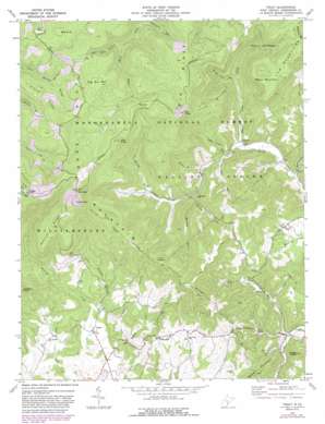
Trout Topo Map West Virginia
To zoom in, hover over the map of Trout
USGS Topo Quad 38080a4 - 1:24,000 scale
| Topo Map Name: | Trout |
| USGS Topo Quad ID: | 38080a4 |
| Print Size: | ca. 21 1/4" wide x 27" high |
| Southeast Coordinates: | 38° N latitude / 80.375° W longitude |
| Map Center Coordinates: | 38.0625° N latitude / 80.4375° W longitude |
| U.S. State: | WV |
| Filename: | o38080a4.jpg |
| Download Map JPG Image: | Trout topo map 1:24,000 scale |
| Map Type: | Topographic |
| Topo Series: | 7.5´ |
| Map Scale: | 1:24,000 |
| Source of Map Images: | United States Geological Survey (USGS) |
| Alternate Map Versions: |
Trout WV 1977, updated 1978 Download PDF Buy paper map Trout WV 1977, updated 1982 Download PDF Buy paper map Trout WV 1977, updated 1989 Download PDF Buy paper map Trout WV 1995, updated 1998 Download PDF Buy paper map Trout WV 2011 Download PDF Buy paper map Trout WV 2014 Download PDF Buy paper map Trout WV 2016 Download PDF Buy paper map |
| FStopo: | US Forest Service topo Trout is available: Download FStopo PDF Download FStopo TIF |
1:24,000 Topo Quads surrounding Trout
> Back to 38080a1 at 1:100,000 scale
> Back to 38080a1 at 1:250,000 scale
> Back to U.S. Topo Maps home
Trout topo map: Gazetteer
Trout: Basins
Cherry Low Place elevation 860m 2821′Trout: Gaps
Low Gap elevation 1247m 4091′Reid Gap elevation 1098m 3602′
Trout: Populated Places
Cordova elevation 749m 2457′Esty elevation 590m 1935′
Friars Hill elevation 717m 2352′
Leonard elevation 701m 2299′
Trout elevation 690m 2263′
Trout: Post Offices
Trout Post Office elevation 691m 2267′Trout: Ridges
Big Ridge elevation 1225m 4019′Chestnut Ridge elevation 1002m 3287′
Cold Knob Mountain elevation 1275m 4183′
Daniel Ridge elevation 1164m 3818′
Loop Mountain elevation 1097m 3599′
Pretty Ridge elevation 1179m 3868′
Trout: Springs
Lowe Spring elevation 760m 2493′Williams Spring elevation 735m 2411′
Trout: Streams
Beard Lick Run elevation 772m 2532′Bee Lick Run elevation 708m 2322′
Beverly Fork elevation 746m 2447′
Blue Knob Branch elevation 979m 3211′
Bull Run elevation 1099m 3605′
Camel Branch elevation 725m 2378′
Camel Branch elevation 706m 2316′
Carr Branch elevation 655m 2148′
Charley Run elevation 676m 2217′
Dry Run elevation 589m 1932′
Little Roaring Creek elevation 710m 2329′
Panther Camp Creek elevation 688m 2257′
Roaring Creek elevation 682m 2237′
Rockcamp Run elevation 661m 2168′
Tom Run elevation 712m 2335′
Walton Run elevation 874m 2867′
Wolfpen Run elevation 755m 2477′
Trout: Summits
Bee Knob elevation 1231m 4038′Big Bull Hill elevation 1169m 3835′
Blue Knob elevation 1228m 4028′
Boggs Knob elevation 794m 2604′
Charley Knob elevation 1027m 3369′
Cold Knob elevation 1314m 4311′
Ellis Knob elevation 1183m 3881′
Grassy Knob elevation 1333m 4373′
Short Mountain elevation 1142m 3746′
Twin Sugars elevation 1098m 3602′
Trout digital topo map on disk
Buy this Trout topo map showing relief, roads, GPS coordinates and other geographical features, as a high-resolution digital map file on DVD:
Western Virginia & Southern West Virginia
Buy digital topo maps: Western Virginia & Southern West Virginia


