Quinwood Topo Map West Virginia
To zoom in, hover over the map of Quinwood
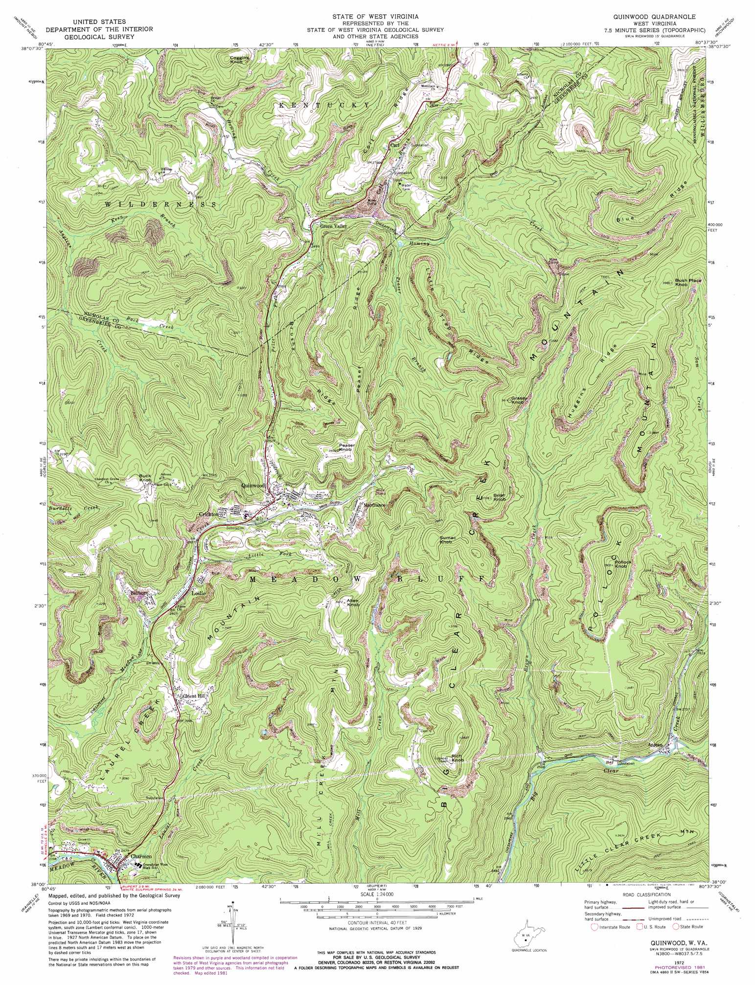
USGS Topo Quad 38080a6 - 1:24,000 scale
| Topo Map Name: | Quinwood |
| USGS Topo Quad ID: | 38080a6 |
| Print Size: | ca. 21 1/4" wide x 27" high |
| Southeast Coordinates: | 38° N latitude / 80.625° W longitude |
| Map Center Coordinates: | 38.0625° N latitude / 80.6875° W longitude |
| U.S. State: | WV |
| Filename: | o38080a6.jpg |
| Download Map JPG Image: | Quinwood topo map 1:24,000 scale |
| Map Type: | Topographic |
| Topo Series: | 7.5´ |
| Map Scale: | 1:24,000 |
| Source of Map Images: | United States Geological Survey (USGS) |
| Alternate Map Versions: |
Quinwood WV 1972, updated 1974 Download PDF Buy paper map Quinwood WV 1972, updated 1982 Download PDF Buy paper map Quinwood WV 1995, updated 1998 Download PDF Buy paper map Quinwood WV 2011 Download PDF Buy paper map Quinwood WV 2014 Download PDF Buy paper map Quinwood WV 2016 Download PDF Buy paper map |
| FStopo: | US Forest Service topo Quinwood is available: Download FStopo PDF Download FStopo TIF |
1:24,000 Topo Quads surrounding Quinwood
Gilboa |
Summersville |
Craigsville |
Camden On Gauley |
Webster Springs Sw |
Summersville Dam |
Mount Nebo |
Nettie |
Richwood |
Fork Mountain |
Winona |
Corliss |
Quinwood |
Duo |
Trout |
Danese |
Rainelle |
Rupert |
Cornstalk |
Williamsburg |
Meadow Creek |
Meadow Bridge |
Dawson |
Asbury |
Lewisburg |
> Back to 38080a1 at 1:100,000 scale
> Back to 38080a1 at 1:250,000 scale
> Back to U.S. Topo Maps home
Quinwood topo map: Gazetteer
Quinwood: Populated Places
Anjean elevation 818m 2683′Bellburn elevation 871m 2857′
Bryant (historical) elevation 841m 2759′
Carl elevation 858m 2814′
Charmco elevation 734m 2408′
Crichton elevation 896m 2939′
Green Valley elevation 764m 2506′
Leslie elevation 866m 2841′
Marfrance elevation 940m 3083′
McClung (historical) elevation 908m 2979′
Orient Hill elevation 922m 3024′
Quinwood elevation 919m 3015′
Walker Hill (historical) elevation 916m 3005′
Quinwood: Post Offices
Charmco Post Office elevation 733m 2404′Leslie Post Office elevation 863m 2831′
Quinwood: Ridges
Big Clear Creek Mountain elevation 1144m 3753′Blue Ridge elevation 1111m 3645′
Brushy Ridge elevation 946m 3103′
Colt Ridge elevation 930m 3051′
Huggins Ridge elevation 1166m 3825′
Little Trap Ridge elevation 952m 3123′
Peaser Ridge elevation 994m 3261′
Pollock Mountain elevation 1171m 3841′
Quinwood: Streams
Back Creek elevation 814m 2670′Brown Creek elevation 784m 2572′
Colt Branch elevation 768m 2519′
Kern Branch elevation 776m 2545′
Laurel Creek elevation 733m 2404′
Little Fork elevation 865m 2837′
Peaser Branch elevation 783m 2568′
Price Fork elevation 748m 2454′
South Fork Big Clear Creek elevation 819m 2687′
Quinwood: Summits
Allen Knob elevation 1120m 3674′Brier Knob elevation 1136m 3727′
Buck Knob elevation 1056m 3464′
Bush Place Knob elevation 1208m 3963′
Coggins Knob elevation 901m 2956′
Grassy Knob elevation 1098m 3602′
Laurel Creek Mountain elevation 1090m 3576′
Mill Creek Mountain elevation 1122m 3681′
Peaser Knob elevation 1039m 3408′
Pollock Knob elevation 1187m 3894′
Rich Knob elevation 1161m 3809′
Sumac Knob elevation 1134m 3720′
Quinwood digital topo map on disk
Buy this Quinwood topo map showing relief, roads, GPS coordinates and other geographical features, as a high-resolution digital map file on DVD:
Western Virginia & Southern West Virginia
Buy digital topo maps: Western Virginia & Southern West Virginia