Edray Topo Map West Virginia
To zoom in, hover over the map of Edray
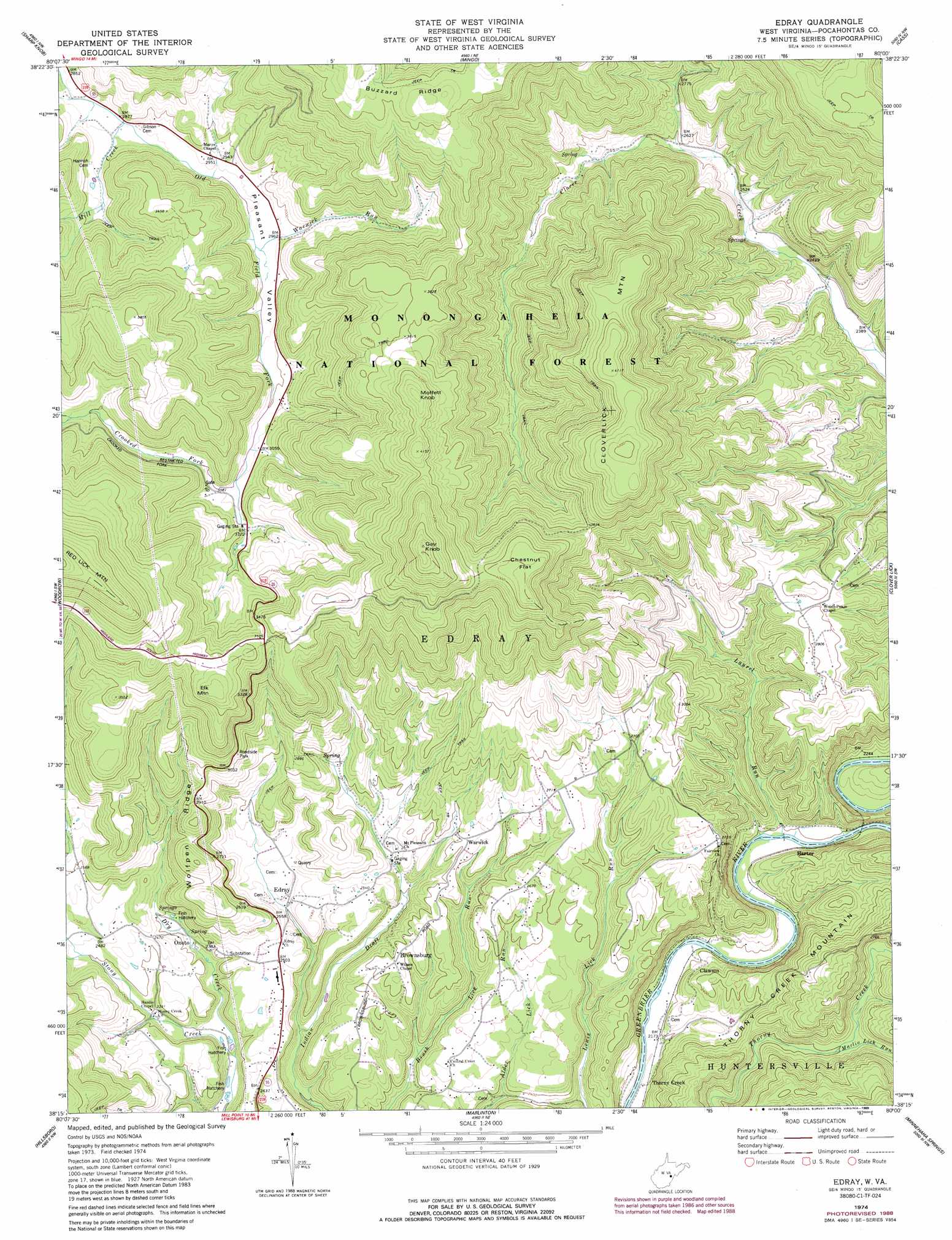
USGS Topo Quad 38080c1 - 1:24,000 scale
| Topo Map Name: | Edray |
| USGS Topo Quad ID: | 38080c1 |
| Print Size: | ca. 21 1/4" wide x 27" high |
| Southeast Coordinates: | 38.25° N latitude / 80° W longitude |
| Map Center Coordinates: | 38.3125° N latitude / 80.0625° W longitude |
| U.S. State: | WV |
| Filename: | o38080c1.jpg |
| Download Map JPG Image: | Edray topo map 1:24,000 scale |
| Map Type: | Topographic |
| Topo Series: | 7.5´ |
| Map Scale: | 1:24,000 |
| Source of Map Images: | United States Geological Survey (USGS) |
| Alternate Map Versions: |
Edray WV 1974, updated 1989 Download PDF Buy paper map Edray WV 1977, updated 1978 Download PDF Buy paper map Edray WV 1995, updated 1998 Download PDF Buy paper map Edray WV 2011 Download PDF Buy paper map Edray WV 2014 Download PDF Buy paper map Edray WV 2016 Download PDF Buy paper map |
| FStopo: | US Forest Service topo Edray is available: Download FStopo PDF Download FStopo TIF |
1:24,000 Topo Quads surrounding Edray
Skelt |
Samp |
Valley Head |
Snyder Knob |
Durbin |
Bergoo |
Sharp Knob |
Mingo |
Cass |
Green Bank |
Webster Springs Se |
Woodrow |
Edray |
Clover Lick |
Paddy Knob |
Lobelia |
Hillsboro |
Marlinton |
Minnehaha Springs |
Sunrise |
Droop |
Denmar |
Lake Sherwood |
Mountain Grove |
Warm Springs |
> Back to 38080a1 at 1:100,000 scale
> Back to 38080a1 at 1:250,000 scale
> Back to U.S. Topo Maps home
Edray topo map: Gazetteer
Edray: Flats
Chestnut Flat elevation 1240m 4068′Edray: Populated Places
Brownsburg elevation 796m 2611′Clawson elevation 667m 2188′
Edray elevation 735m 2411′
Harter elevation 673m 2208′
Onoto elevation 717m 2352′
Thorny Creek elevation 661m 2168′
Warwick elevation 795m 2608′
Edray: Ridges
Wolfpen Ridge elevation 918m 3011′Edray: Springs
Averill Spring elevation 777m 2549′Hannan Spring elevation 756m 2480′
McLaughlin Spring elevation 729m 2391′
Thomas Spring elevation 825m 2706′
Edray: Streams
Crooked Fork elevation 931m 3054′Dry Creek elevation 685m 2247′
Laurel Run elevation 669m 2194′
Marlin Lick Run elevation 734m 2408′
Mill Creek elevation 875m 2870′
Warwick Run elevation 891m 2923′
Edray: Summits
Cloverlick Mountain elevation 1292m 4238′Elk Mountain elevation 1147m 3763′
Gay Knob elevation 1386m 4547′
Moffett Knob elevation 1271m 4169′
Edray: Valleys
Pleasant Valley elevation 890m 2919′Edray digital topo map on disk
Buy this Edray topo map showing relief, roads, GPS coordinates and other geographical features, as a high-resolution digital map file on DVD:
Western Virginia & Southern West Virginia
Buy digital topo maps: Western Virginia & Southern West Virginia