Webster Springs Sw Topo Map West Virginia
To zoom in, hover over the map of Webster Springs Sw
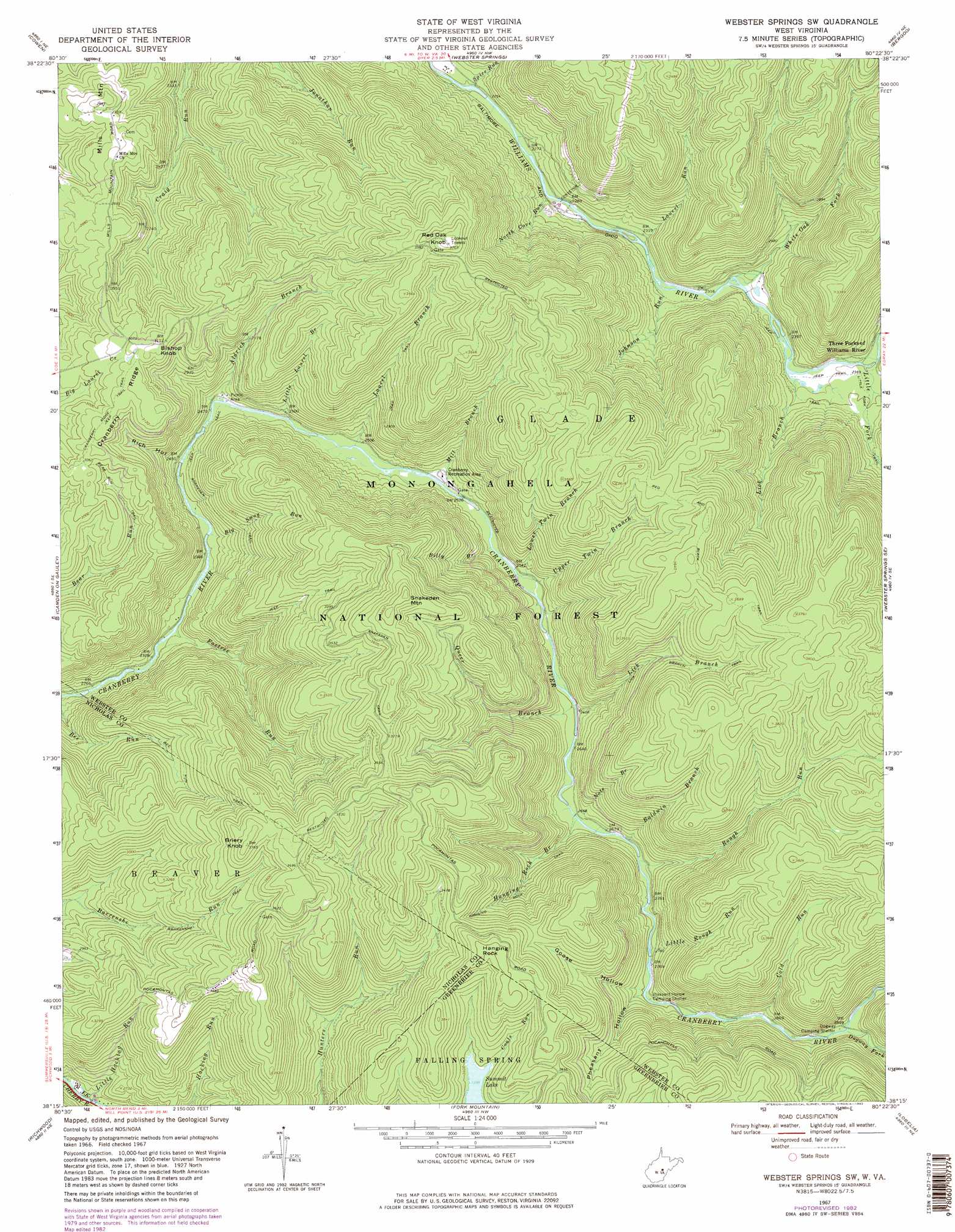
USGS Topo Quad 38080c4 - 1:24,000 scale
| Topo Map Name: | Webster Springs Sw |
| USGS Topo Quad ID: | 38080c4 |
| Print Size: | ca. 21 1/4" wide x 27" high |
| Southeast Coordinates: | 38.25° N latitude / 80.375° W longitude |
| Map Center Coordinates: | 38.3125° N latitude / 80.4375° W longitude |
| U.S. State: | WV |
| Filename: | o38080c4.jpg |
| Download Map JPG Image: | Webster Springs Sw topo map 1:24,000 scale |
| Map Type: | Topographic |
| Topo Series: | 7.5´ |
| Map Scale: | 1:24,000 |
| Source of Map Images: | United States Geological Survey (USGS) |
| Alternate Map Versions: |
Webster Springs SW WV 1967, updated 1970 Download PDF Buy paper map Webster Springs SW WV 1967, updated 1977 Download PDF Buy paper map Webster Springs SW WV 1967, updated 1982 Download PDF Buy paper map Webster Springs SW WV 1995, updated 1998 Download PDF Buy paper map Webster Springs SW WV 2011 Download PDF Buy paper map Webster Springs SW WV 2014 Download PDF Buy paper map Webster Springs SW WV 2016 Download PDF Buy paper map |
| FStopo: | US Forest Service topo Webster Springs SW is available: Download FStopo PDF Download FStopo TIF |
1:24,000 Topo Quads surrounding Webster Springs Sw
Little Birch |
Erbacon |
Diana |
Skelt |
Samp |
Tioga |
Cowen |
Webster Springs |
Bergoo |
Sharp Knob |
Craigsville |
Camden On Gauley |
Webster Springs Sw |
Webster Springs Se |
Woodrow |
Nettie |
Richwood |
Fork Mountain |
Lobelia |
Hillsboro |
Quinwood |
Duo |
Trout |
Droop |
Denmar |
> Back to 38080a1 at 1:100,000 scale
> Back to 38080a1 at 1:250,000 scale
> Back to U.S. Topo Maps home
Webster Springs Sw topo map: Gazetteer
Webster Springs Sw: Parks
Bishop Knob Recreation Area elevation 943m 3093′Cranberry Back Country elevation 936m 3070′
Cranberry Wildlife Management Area elevation 852m 2795′
Webster Springs Sw: Ridges
Mills Mountain elevation 865m 2837′Webster Springs Sw: Streams
Aldrich Branch elevation 750m 2460′Baldwin Branch elevation 815m 2673′
Big Swag Run elevation 720m 2362′
Billy Branch elevation 779m 2555′
Cold Run elevation 867m 2844′
Dogway Fork elevation 882m 2893′
Foxtree Run elevation 708m 2322′
Hanging Rock Branch elevation 809m 2654′
Johnson Run elevation 697m 2286′
Laurel Branch elevation 760m 2493′
Laurel Run elevation 695m 2280′
Lick Branch elevation 792m 2598′
Lick Branch elevation 713m 2339′
Little Fork elevation 721m 2365′
Little Hacking Run elevation 761m 2496′
Little Laurel Branch elevation 755m 2477′
Little Rough Run elevation 839m 2752′
Lower Twin Branch elevation 778m 2552′
Middle Fork Williams River elevation 726m 2381′
Mill Branch elevation 766m 2513′
North Cove Run elevation 693m 2273′
Note Branch elevation 809m 2654′
Queer Branch elevation 791m 2595′
Rough Run elevation 820m 2690′
Spice Run elevation 683m 2240′
Upper Twin Branch elevation 779m 2555′
White Oak Fork elevation 710m 2329′
Webster Springs Sw: Summits
Bishop Knob elevation 954m 3129′Briery Knob elevation 1145m 3756′
Hanging Rock elevation 1167m 3828′
Red Oak Knob elevation 1129m 3704′
Snakeden Mountain elevation 1169m 3835′
Webster Springs Sw: Trails
Barrenshe Trail elevation 841m 2759′Bear Run Trail elevation 838m 2749′
Bee Run Trail elevation 924m 3031′
Hanging Rock Trail elevation 900m 2952′
Lick Branch Trail elevation 980m 3215′
Snakeden Trail elevation 778m 2552′
Webster Springs Sw: Valleys
Goose Hollow elevation 866m 2841′Pheasant Hollow elevation 863m 2831′
Rich Hollow elevation 796m 2611′
Webster Springs Sw digital topo map on disk
Buy this Webster Springs Sw topo map showing relief, roads, GPS coordinates and other geographical features, as a high-resolution digital map file on DVD:
Western Virginia & Southern West Virginia
Buy digital topo maps: Western Virginia & Southern West Virginia