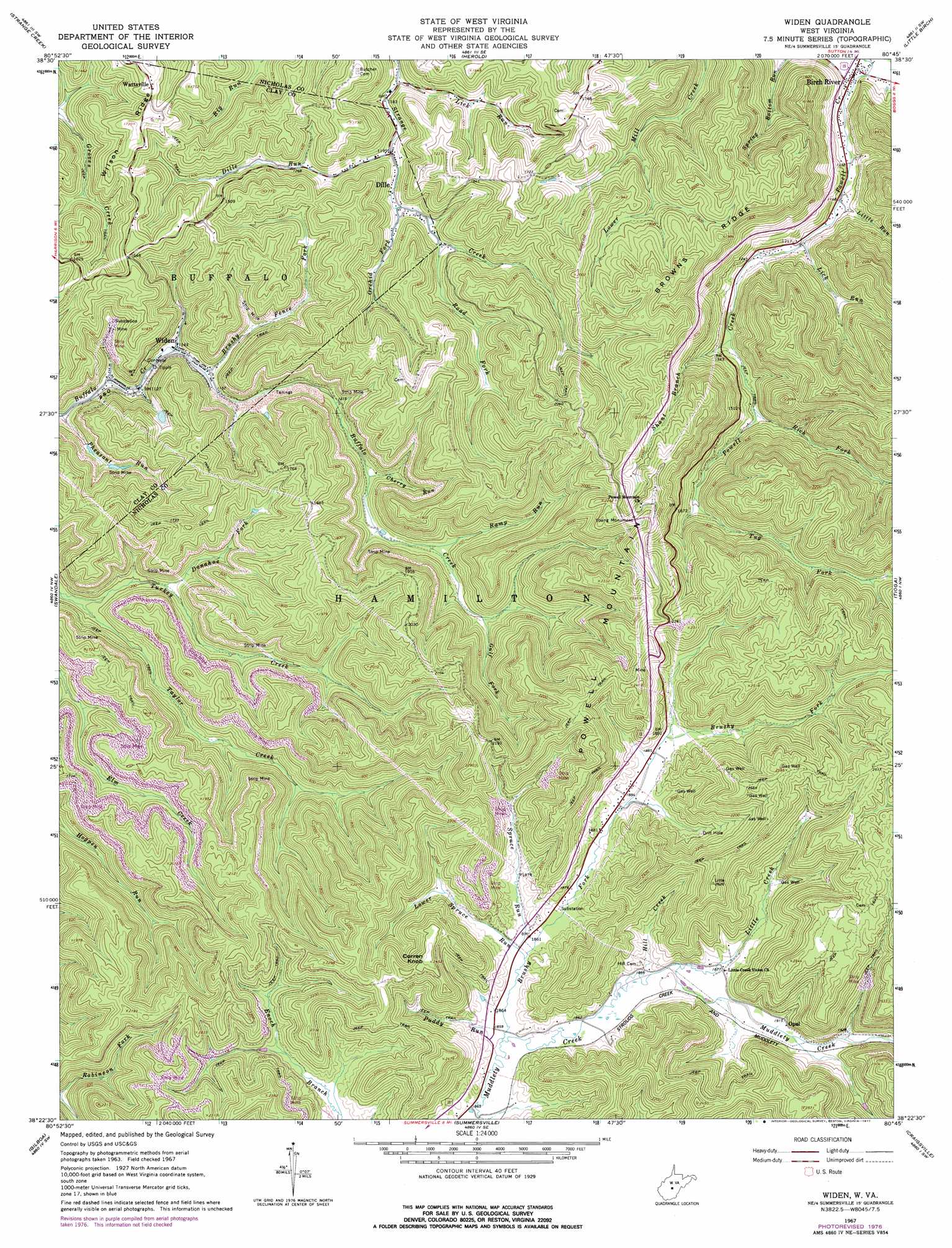
Widen Topo Map West Virginia
To zoom in, hover over the map of Widen
USGS Topo Quad 38080d7 - 1:24,000 scale
| Topo Map Name: | Widen |
| USGS Topo Quad ID: | 38080d7 |
| Print Size: | ca. 21 1/4" wide x 27" high |
| Southeast Coordinates: | 38.375° N latitude / 80.75° W longitude |
| Map Center Coordinates: | 38.4375° N latitude / 80.8125° W longitude |
| U.S. State: | WV |
| Filename: | o38080d7.jpg |
| Download Map JPG Image: | Widen topo map 1:24,000 scale |
| Map Type: | Topographic |
| Topo Series: | 7.5´ |
| Map Scale: | 1:24,000 |
| Source of Map Images: | United States Geological Survey (USGS) |
| Alternate Map Versions: |
Widen WV 1967, updated 1968 Download PDF Buy paper map Widen WV 1967, updated 1977 Download PDF Buy paper map Widen WV 2010 Download PDF Buy paper map Widen WV 2014 Download PDF Buy paper map Widen WV 2016 Download PDF Buy paper map |
1:24,000 Topo Quads surrounding Widen
Chloe |
Rosedale |
Gassaway |
Sutton |
Newville |
Ivydale |
Strange Creek |
Herold |
Little Birch |
Erbacon |
Clay |
Swandale |
Widen |
Tioga |
Cowen |
Lockwood |
Gilboa |
Summersville |
Craigsville |
Camden On Gauley |
Ansted |
Summersville Dam |
Mount Nebo |
Nettie |
Richwood |
> Back to 38080a1 at 1:100,000 scale
> Back to 38080a1 at 1:250,000 scale
> Back to U.S. Topo Maps home
Widen topo map: Gazetteer
Widen: Parks
Young Monument elevation 660m 2165′Widen: Populated Places
Birch River elevation 339m 1112′Dille elevation 366m 1200′
Opal elevation 586m 1922′
Wattsville elevation 506m 1660′
Widen elevation 350m 1148′
Widen: Post Offices
Birch River Post Office elevation 339m 1112′Dille Post Office elevation 365m 1197′
Widen Post Office elevation 352m 1154′
Widen: Ridges
Browns Ridge elevation 619m 2030′Powell Mountain elevation 742m 2434′
Widen: Streams
Brushy Fence Fork elevation 350m 1148′Brushy Fork elevation 565m 1853′
Cherry Run elevation 381m 1250′
Dille Run elevation 365m 1197′
Donahoe Fork elevation 371m 1217′
Gulf Fork elevation 428m 1404′
Hill Creek elevation 570m 1870′
Lick Run elevation 361m 1184′
Lick Run elevation 366m 1200′
Little Creek elevation 571m 1873′
Little Run elevation 355m 1164′
Lower Spruce Run elevation 567m 1860′
Orchid Fork elevation 374m 1227′
Pheasant Run elevation 336m 1102′
Puddy Run elevation 565m 1853′
Ramp Run elevation 407m 1335′
Rich Fork elevation 416m 1364′
Road Fork elevation 387m 1269′
Shant Branch elevation 393m 1289′
Spruce Run elevation 568m 1863′
Tug Fork elevation 485m 1591′
Turkey Creek elevation 350m 1148′
Widen: Summits
Corren Knob elevation 745m 2444′Widen digital topo map on disk
Buy this Widen topo map showing relief, roads, GPS coordinates and other geographical features, as a high-resolution digital map file on DVD:
Western Virginia & Southern West Virginia
Buy digital topo maps: Western Virginia & Southern West Virginia