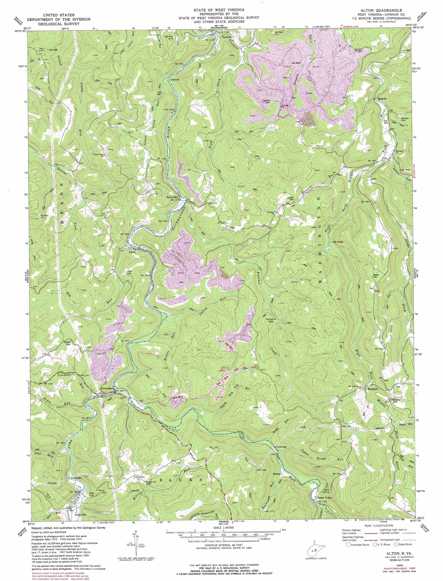
Alton Topo Map West Virginia
To zoom in, hover over the map of Alton
USGS Topo Quad 38080g2 - 1:24,000 scale
| Topo Map Name: | Alton |
| USGS Topo Quad ID: | 38080g2 |
| Print Size: | ca. 21 1/4" wide x 27" high |
| Southeast Coordinates: | 38.75° N latitude / 80.125° W longitude |
| Map Center Coordinates: | 38.8125° N latitude / 80.1875° W longitude |
| U.S. State: | WV |
| Filename: | o38080g2.jpg |
| Download Map JPG Image: | Alton topo map 1:24,000 scale |
| Map Type: | Topographic |
| Topo Series: | 7.5´ |
| Map Scale: | 1:24,000 |
| Source of Map Images: | United States Geological Survey (USGS) |
| Alternate Map Versions: |
Alton WV 1974, updated 1989 Download PDF Buy paper map Alton WV 1977, updated 1977 Download PDF Buy paper map Alton WV 2010 Download PDF Buy paper map Alton WV 2014 Download PDF Buy paper map Alton WV 2016 Download PDF Buy paper map |
1:24,000 Topo Quads surrounding Alton
Weston |
Berlin |
Century |
Audra |
Belington |
Roanoke |
Adrian |
Buckhannon |
Ellamore |
Junior |
Walkersville |
Rock Cave |
Alton |
Cassity |
Beverly West |
Hacker Valley |
Goshen |
Pickens |
Adolph |
Mill Creek |
Diana |
Skelt |
Samp |
Valley Head |
Snyder Knob |
> Back to 38080e1 at 1:100,000 scale
> Back to 38080a1 at 1:250,000 scale
> Back to U.S. Topo Maps home
Alton topo map: Gazetteer
Alton: Populated Places
Alexander elevation 564m 1850′Alton elevation 545m 1788′
Beans Mill elevation 540m 1771′
Chemical (historical) elevation 572m 1876′
Hemlock elevation 730m 2395′
Imperial elevation 503m 1650′
Palace Valley elevation 637m 2089′
Queens elevation 593m 1945′
Selbyville elevation 575m 1886′
Sellers (historical) elevation 495m 1624′
Shahan elevation 618m 2027′
Tenmile elevation 494m 1620′
Alton: Springs
Leonard Run School Spring elevation 685m 2247′Alton: Streams
Alec Run elevation 566m 1856′Bearcamp Run elevation 611m 2004′
Bens Run elevation 573m 1879′
Big Run elevation 544m 1784′
Cold Run elevation 793m 2601′
Herods Run elevation 550m 1804′
Indian Camp Run elevation 501m 1643′
Jackson Fork elevation 599m 1965′
Jenks Fork elevation 606m 1988′
Left Fork Buckhannon River elevation 560m 1837′
Left Fork Right Fork Buckhannon River elevation 644m 2112′
Leonard Run elevation 616m 2020′
Lick Run elevation 639m 2096′
Millsite Run elevation 570m 1870′
Panther Creek elevation 536m 1758′
Reger Run elevation 561m 1840′
Right Fork Buckhannon River elevation 560m 1837′
Right Fork Tenmile Creek elevation 504m 1653′
Rough Run elevation 609m 1998′
Simmons Run elevation 561m 1840′
Smooth Rock Lick Run elevation 581m 1906′
Sugar Run elevation 771m 2529′
Swamp Run elevation 550m 1804′
Upper Rough Run elevation 612m 2007′
Alton: Summits
Church Knob elevation 736m 2414′Alton digital topo map on disk
Buy this Alton topo map showing relief, roads, GPS coordinates and other geographical features, as a high-resolution digital map file on DVD:
Western Virginia & Southern West Virginia
Buy digital topo maps: Western Virginia & Southern West Virginia