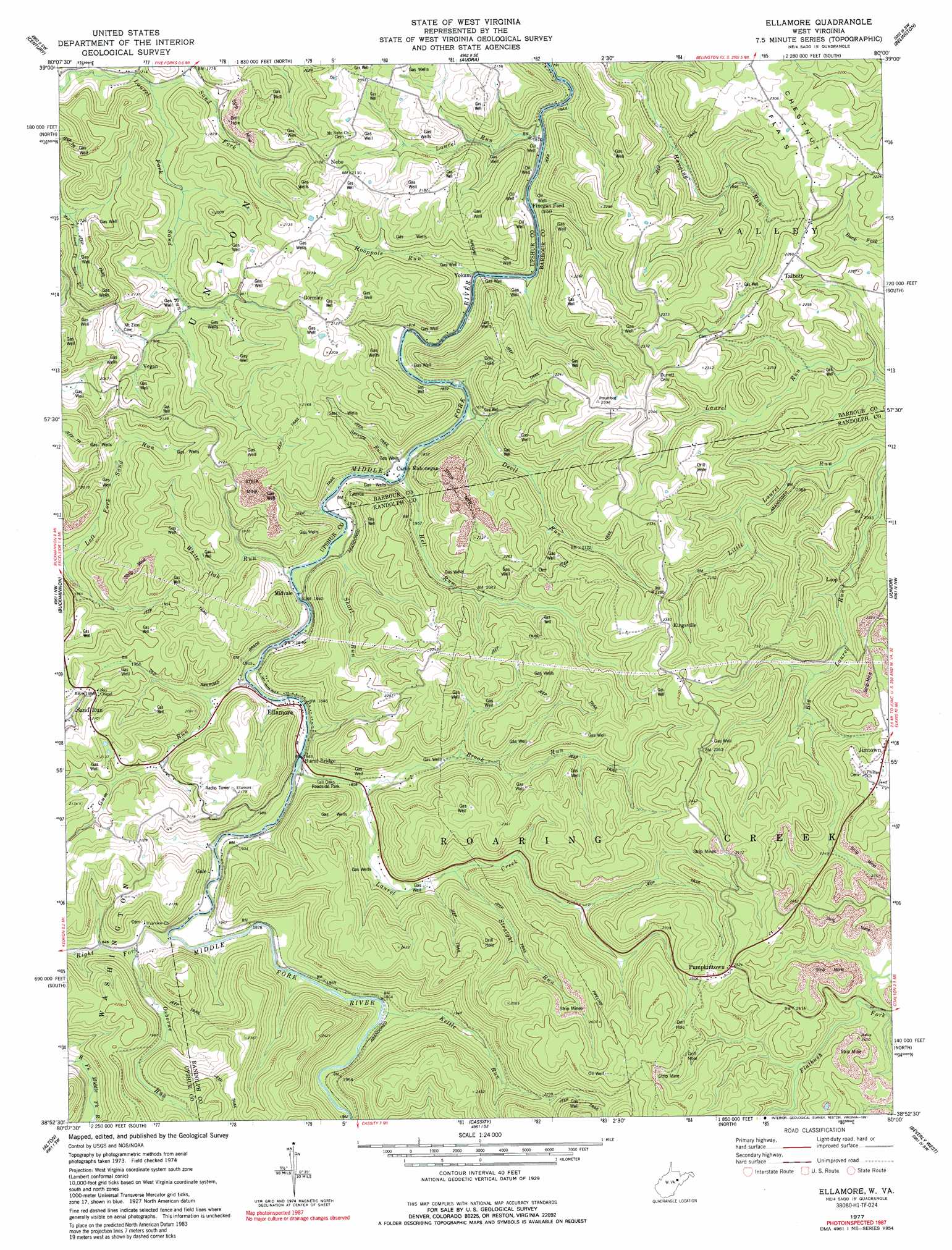
Ellamore Topo Map West Virginia
To zoom in, hover over the map of Ellamore
USGS Topo Quad 38080h1 - 1:24,000 scale
| Topo Map Name: | Ellamore |
| USGS Topo Quad ID: | 38080h1 |
| Print Size: | ca. 21 1/4" wide x 27" high |
| Southeast Coordinates: | 38.875° N latitude / 80° W longitude |
| Map Center Coordinates: | 38.9375° N latitude / 80.0625° W longitude |
| U.S. State: | WV |
| Filename: | o38080h1.jpg |
| Download Map JPG Image: | Ellamore topo map 1:24,000 scale |
| Map Type: | Topographic |
| Topo Series: | 7.5´ |
| Map Scale: | 1:24,000 |
| Source of Map Images: | United States Geological Survey (USGS) |
| Alternate Map Versions: |
Ellamore WV 1977, updated 1977 Download PDF Buy paper map Ellamore WV 1977, updated 1991 Download PDF Buy paper map Ellamore WV 2011 Download PDF Buy paper map Ellamore WV 2014 Download PDF Buy paper map Ellamore WV 2016 Download PDF Buy paper map |
1:24,000 Topo Quads surrounding Ellamore
Mount Clare |
Brownton |
Philippi |
Nestorville |
Colebank |
Berlin |
Century |
Audra |
Belington |
Montrose |
Adrian |
Buckhannon |
Ellamore |
Junior |
Elkins |
Rock Cave |
Alton |
Cassity |
Beverly West |
Beverly East |
Goshen |
Pickens |
Adolph |
Mill Creek |
Wildell |
> Back to 38080e1 at 1:100,000 scale
> Back to 38080a1 at 1:250,000 scale
> Back to U.S. Topo Maps home
Ellamore topo map: Gazetteer
Ellamore: Flats
Chestnut Flats elevation 692m 2270′Ellamore: Parks
Tall Oaks Roadside Park elevation 565m 1853′Ellamore: Populated Places
Ellamore elevation 566m 1856′Finegan Ford elevation 554m 1817′
Gale elevation 571m 1873′
Gormley elevation 643m 2109′
Jimtown elevation 729m 2391′
Kingsville elevation 720m 2362′
Lantz elevation 576m 1889′
Middle Fork (historical) elevation 570m 1870′
Midvale elevation 563m 1847′
Nebo elevation 641m 2103′
Orr elevation 667m 2188′
Pumpkintown elevation 769m 2522′
Sand Run elevation 598m 1961′
Talbott elevation 690m 2263′
Vegan elevation 589m 1932′
Yokum elevation 563m 1847′
Ellamore: Post Offices
Kingsville Post Office (historical) elevation 730m 2395′Ellamore: Springs
Ellamore School Spring elevation 614m 2014′Ellamore: Streams
Brook Run elevation 568m 1863′Devil Run elevation 552m 1811′
Gum Run elevation 561m 1840′
Hooppole Run elevation 551m 1807′
Kettle Run elevation 571m 1873′
Laurel Creek elevation 558m 1830′
Laurel Run elevation 569m 1866′
Laurel Run elevation 551m 1807′
Osborne Run elevation 561m 1840′
Right Fork Middle Fork River elevation 561m 1840′
Sand Fork elevation 524m 1719′
Service Run elevation 556m 1824′
Short Run elevation 555m 1820′
Straight Run elevation 601m 1971′
White Oak Run elevation 556m 1824′
Ellamore: Summits
Deen Knob elevation 629m 2063′Ellamore digital topo map on disk
Buy this Ellamore topo map showing relief, roads, GPS coordinates and other geographical features, as a high-resolution digital map file on DVD:
Western Virginia & Southern West Virginia
Buy digital topo maps: Western Virginia & Southern West Virginia