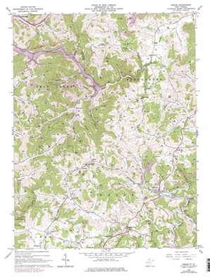
Adrian Topo Map West Virginia
To zoom in, hover over the map of Adrian
USGS Topo Quad 38080h3 - 1:24,000 scale
| Topo Map Name: | Adrian |
| USGS Topo Quad ID: | 38080h3 |
| Print Size: | ca. 21 1/4" wide x 27" high |
| Southeast Coordinates: | 38.875° N latitude / 80.25° W longitude |
| Map Center Coordinates: | 38.9375° N latitude / 80.3125° W longitude |
| U.S. State: | WV |
| Filename: | o38080h3.jpg |
| Download Map JPG Image: | Adrian topo map 1:24,000 scale |
| Map Type: | Topographic |
| Topo Series: | 7.5´ |
| Map Scale: | 1:24,000 |
| Source of Map Images: | United States Geological Survey (USGS) |
| Alternate Map Versions: |
Adrian WV 1966, updated 1967 Download PDF Buy paper map Adrian WV 1966, updated 1979 Download PDF Buy paper map Adrian WV 2011 Download PDF Buy paper map Adrian WV 2014 Download PDF Buy paper map Adrian WV 2016 Download PDF Buy paper map |
1:24,000 Topo Quads surrounding Adrian
> Back to 38080e1 at 1:100,000 scale
> Back to 38080a1 at 1:250,000 scale
> Back to U.S. Topo Maps home
Adrian topo map: Gazetteer
Adrian: Airports
Buckhannon-Upshur County Airport elevation 435m 1427′Adrian: Parks
Stonecoal Lake Wildlife Management Area elevation 399m 1309′Adrian: Populated Places
Abbott elevation 455m 1492′Adrian elevation 441m 1446′
Atlas elevation 441m 1446′
Freeman elevation 463m 1519′
French Creek elevation 445m 1459′
Gould elevation 444m 1456′
Hinkleville elevation 489m 1604′
Hoover Town elevation 483m 1584′
McCuetown elevation 377m 1236′
Rocky Ford elevation 430m 1410′
Adrian: Post Offices
Frenchton Post Office elevation 459m 1505′Adrian: Springs
Day Helmick Spring elevation 476m 1561′Adrian: Streams
Bear Run elevation 351m 1151′Beaver Run elevation 442m 1450′
Beechlick Run elevation 328m 1076′
Blacklick Run elevation 436m 1430′
Brush Run elevation 437m 1433′
Brushlick Run elevation 342m 1122′
Brushy Fork elevation 429m 1407′
Bull Run elevation 432m 1417′
Crooked Run elevation 431m 1414′
Fall Run elevation 384m 1259′
Glady Fork elevation 383m 1256′
Grand Camp Run elevation 433m 1420′
Kittle Run elevation 437m 1433′
Laurel Fork elevation 434m 1423′
Lick Run elevation 434m 1423′
Little Brush Run elevation 440m 1443′
Log Hollow Run elevation 361m 1184′
Morgan Run elevation 438m 1437′
Mudlick Run elevation 437m 1433′
New Found Run elevation 436m 1430′
Pigeonroost Run elevation 343m 1125′
Pringle Fork elevation 342m 1122′
Slab Camp Fork elevation 443m 1453′
Snyder Run elevation 329m 1079′
Spruce Fork elevation 382m 1253′
Straight Run elevation 342m 1122′
Wolfpen Run elevation 342m 1122′
Adrian: Summits
Buckhannon Mountain elevation 541m 1774′Adrian: Valleys
Grub Hollow elevation 438m 1437′Adrian digital topo map on disk
Buy this Adrian topo map showing relief, roads, GPS coordinates and other geographical features, as a high-resolution digital map file on DVD:
Western Virginia & Southern West Virginia
Buy digital topo maps: Western Virginia & Southern West Virginia


