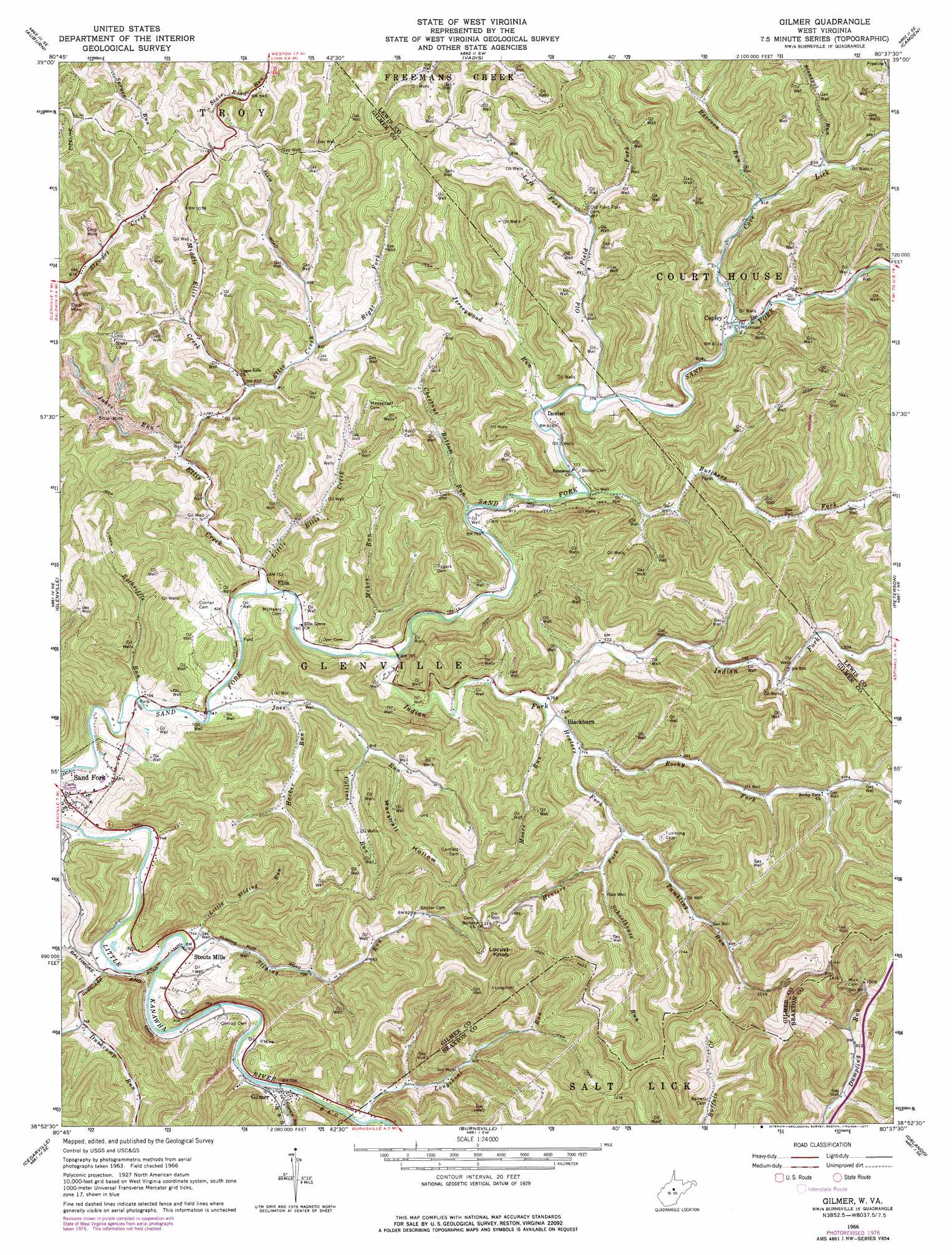
Gilmer Topo Map West Virginia
To zoom in, hover over the map of Gilmer
USGS Topo Quad 38080h6 - 1:24,000 scale
| Topo Map Name: | Gilmer |
| USGS Topo Quad ID: | 38080h6 |
| Print Size: | ca. 21 1/4" wide x 27" high |
| Southeast Coordinates: | 38.875° N latitude / 80.625° W longitude |
| Map Center Coordinates: | 38.9375° N latitude / 80.6875° W longitude |
| U.S. State: | WV |
| Filename: | o38080h6.jpg |
| Download Map JPG Image: | Gilmer topo map 1:24,000 scale |
| Map Type: | Topographic |
| Topo Series: | 7.5´ |
| Map Scale: | 1:24,000 |
| Source of Map Images: | United States Geological Survey (USGS) |
| Alternate Map Versions: |
Gilmer WV 1966, updated 1968 Download PDF Buy paper map Gilmer WV 1966, updated 1977 Download PDF Buy paper map Gilmer WV 2011 Download PDF Buy paper map Gilmer WV 2014 Download PDF Buy paper map Gilmer WV 2016 Download PDF Buy paper map |
1:24,000 Topo Quads surrounding Gilmer
Pullman |
Oxford |
New Milton |
Big Isaac |
West Milford |
Burnt House |
Auburn |
Vadis |
Camden |
Weston |
Tanner |
Glenville |
Gilmer |
Peterson |
Roanoke |
Normantown |
Cedarville |
Burnsville |
Orlando |
Walkersville |
Rosedale |
Gassaway |
Sutton |
Newville |
Hacker Valley |
> Back to 38080e1 at 1:100,000 scale
> Back to 38080a1 at 1:250,000 scale
> Back to U.S. Topo Maps home
Gilmer topo map: Gazetteer
Gilmer: Populated Places
Blackburn elevation 232m 761′Copley elevation 243m 797′
Donlan elevation 242m 793′
Ellis elevation 224m 734′
Gilmer elevation 230m 754′
Sand Fork elevation 224m 734′
Stouts Mills elevation 225m 738′
Gilmer: Post Offices
Gilmer Post Office elevation 224m 734′Stouts Mills Post Office elevation 244m 800′
Gilmer: Streams
Butchers Fork elevation 229m 751′Chestnut Bottom Run elevation 228m 748′
Collins Run elevation 246m 807′
Copen Run elevation 223m 731′
Cove Lick elevation 239m 784′
Duskcamp Run elevation 223m 731′
Ellis Creek elevation 225m 738′
Fork Ellis Creek elevation 254m 833′
Hacker Run elevation 231m 757′
Heaters Fork elevation 314m 1030′
Indian Fork elevation 227m 744′
Jakes Run elevation 237m 777′
Jerseywood Run elevation 232m 761′
Joes Run elevation 224m 734′
Left Fork Old Field Fork elevation 260m 853′
Lick Run elevation 221m 725′
Little Ellis Creek elevation 225m 738′
Little Sliding Run elevation 225m 738′
Longshoal Run elevation 225m 738′
Middle Ellis Creek elevation 246m 807′
Mikes Run elevation 225m 738′
Moore Run elevation 230m 754′
Old Field Fork elevation 235m 770′
Raccoon Run elevation 247m 810′
Right Fork Duskcamp Run elevation 227m 744′
Rockriffle Run elevation 221m 725′
Rocky Fork elevation 234m 767′
Schoolhouse Run elevation 255m 836′
Sliding Run elevation 221m 725′
Stonepot Run elevation 252m 826′
Tomblin Run elevation 247m 810′
Gilmer: Summits
Locust Knob elevation 477m 1564′Gilmer: Valleys
Marshall Hollow elevation 262m 859′Gilmer digital topo map on disk
Buy this Gilmer topo map showing relief, roads, GPS coordinates and other geographical features, as a high-resolution digital map file on DVD:
Western Virginia & Southern West Virginia
Buy digital topo maps: Western Virginia & Southern West Virginia