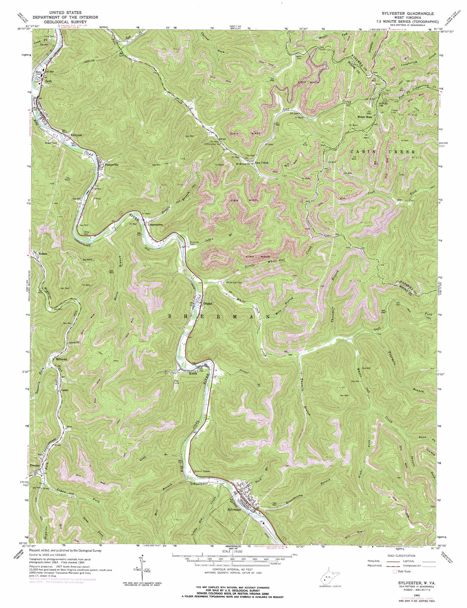
Sylvester Topo Map West Virginia
To zoom in, hover over the map of Sylvester
USGS Topo Quad 38081a5 - 1:24,000 scale
| Topo Map Name: | Sylvester |
| USGS Topo Quad ID: | 38081a5 |
| Print Size: | ca. 21 1/4" wide x 27" high |
| Southeast Coordinates: | 38° N latitude / 81.5° W longitude |
| Map Center Coordinates: | 38.0625° N latitude / 81.5625° W longitude |
| U.S. State: | WV |
| Filename: | o38081a5.jpg |
| Download Map JPG Image: | Sylvester topo map 1:24,000 scale |
| Map Type: | Topographic |
| Topo Series: | 7.5´ |
| Map Scale: | 1:24,000 |
| Source of Map Images: | United States Geological Survey (USGS) |
| Alternate Map Versions: |
Sylvester WV 1965, updated 1966 Download PDF Buy paper map Sylvester WV 1965, updated 1977 Download PDF Buy paper map Sylvester WV 1996, updated 2002 Download PDF Buy paper map Sylvester WV 2011 Download PDF Buy paper map Sylvester WV 2014 Download PDF Buy paper map Sylvester WV 2016 Download PDF Buy paper map |
1:24,000 Topo Quads surrounding Sylvester
Alum Creek |
Charleston West |
Charleston East |
Quick |
Mammoth |
Julian |
Racine |
Belle |
Cedar Grove |
Montgomery |
Madison |
Williams Mountain |
Sylvester |
Eskdale |
Powellton |
Clothier |
Wharton |
Whitesville |
Dorothy |
Pax |
Amherstdale |
Lorado |
Pilot Knob |
Arnett |
Eccles |
> Back to 38081a1 at 1:100,000 scale
> Back to 38080a1 at 1:250,000 scale
> Back to U.S. Topo Maps home
Sylvester topo map: Gazetteer
Sylvester: Populated Places
Cabot elevation 265m 869′Coopertown elevation 219m 718′
Fosterville elevation 215m 705′
Joes Creek elevation 292m 958′
Keith elevation 231m 757′
Kirbyton elevation 215m 705′
Milltown elevation 261m 856′
Mount Hope elevation 505m 1656′
Nelson elevation 234m 767′
Orgas elevation 226m 741′
Seth elevation 214m 702′
Sylvester elevation 264m 866′
Sylvester: Post Offices
Orgas Post Office elevation 224m 734′Sylvester: Streams
Big Jarrells Creek elevation 285m 935′Coon Fork elevation 207m 679′
Fourmile Branch elevation 297m 974′
Gidd Branch elevation 232m 761′
Haggle Branch elevation 216m 708′
Horse Branch elevation 217m 711′
Jakes Branch elevation 219m 718′
Laurel Creek elevation 206m 675′
Lavinia Fork elevation 259m 849′
Left Fork Joes Creek elevation 221m 725′
Left Fork White Oak Creek elevation 274m 898′
Little Elk Creek elevation 233m 764′
Little White Oak Creek elevation 227m 744′
Logan Fork elevation 287m 941′
Mile Branch elevation 240m 787′
Mill Branch elevation 232m 761′
Pack Branch elevation 238m 780′
Right Fork White Oak Creek elevation 312m 1023′
Road Fork elevation 345m 1131′
Roundbottom Branch elevation 237m 777′
Seng Fork elevation 304m 997′
Spruce Fork elevation 343m 1125′
Stover Branch elevation 226m 741′
Threemile Branch elevation 270m 885′
Twomile Branch elevation 259m 849′
White Oak Creek elevation 220m 721′
Sylvester digital topo map on disk
Buy this Sylvester topo map showing relief, roads, GPS coordinates and other geographical features, as a high-resolution digital map file on DVD:
Western Virginia & Southern West Virginia
Buy digital topo maps: Western Virginia & Southern West Virginia