Montgomery Topo Map West Virginia
To zoom in, hover over the map of Montgomery
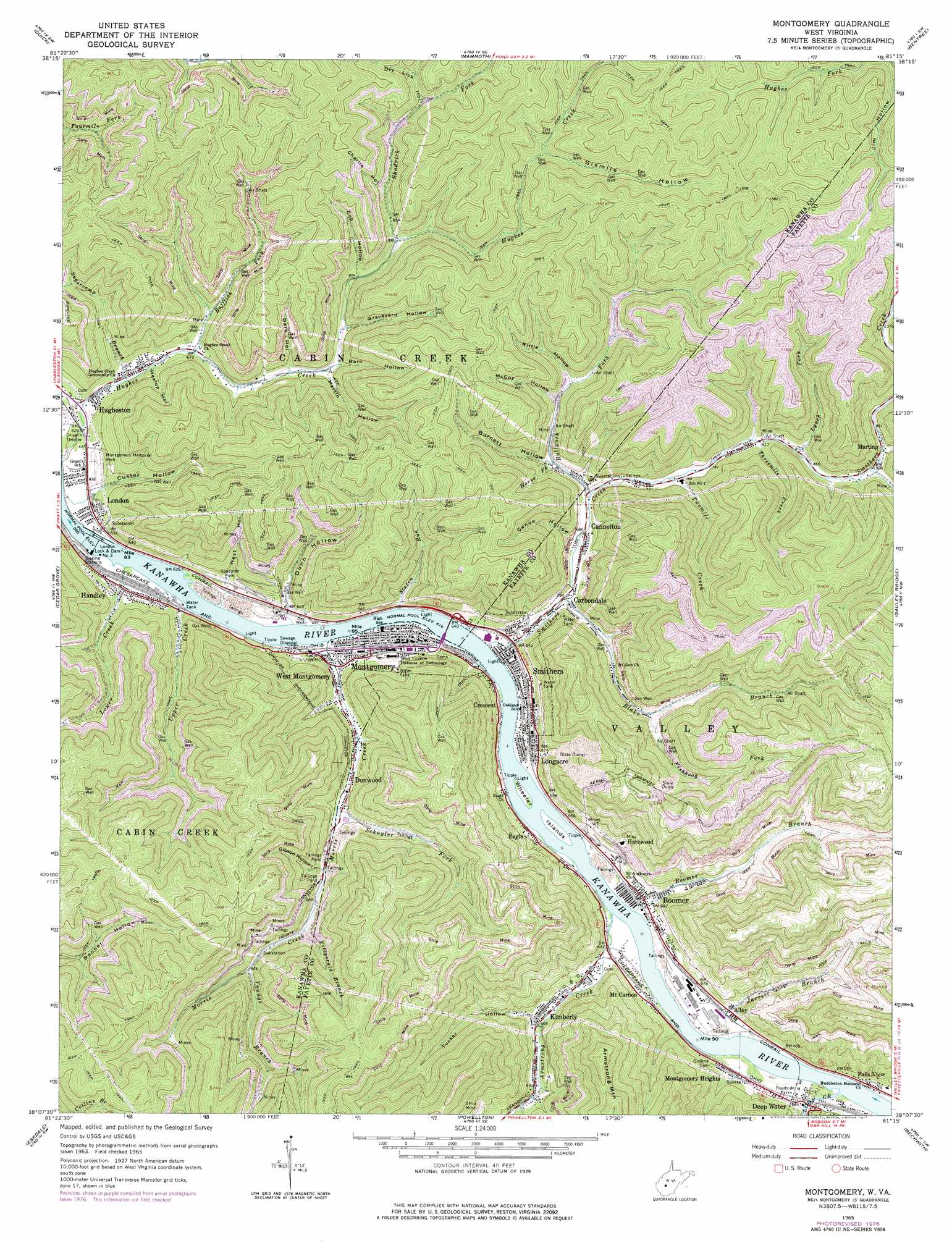
USGS Topo Quad 38081b3 - 1:24,000 scale
| Topo Map Name: | Montgomery |
| USGS Topo Quad ID: | 38081b3 |
| Print Size: | ca. 21 1/4" wide x 27" high |
| Southeast Coordinates: | 38.125° N latitude / 81.25° W longitude |
| Map Center Coordinates: | 38.1875° N latitude / 81.3125° W longitude |
| U.S. State: | WV |
| Filename: | o38081b3.jpg |
| Download Map JPG Image: | Montgomery topo map 1:24,000 scale |
| Map Type: | Topographic |
| Topo Series: | 7.5´ |
| Map Scale: | 1:24,000 |
| Source of Map Images: | United States Geological Survey (USGS) |
| Alternate Map Versions: |
Montgomery WV 1965, updated 1966 Download PDF Buy paper map Montgomery WV 1965, updated 1977 Download PDF Buy paper map Montgomery WV 1977, updated 1980 Download PDF Buy paper map Montgomery WV 1996, updated 2002 Download PDF Buy paper map Montgomery WV 2011 Download PDF Buy paper map Montgomery WV 2014 Download PDF Buy paper map Montgomery WV 2016 Download PDF Buy paper map |
1:24,000 Topo Quads surrounding Montgomery
Big Chimney |
Blue Creek |
Clendenin |
Elkhurst |
Clay |
Charleston East |
Quick |
Mammoth |
Bentree |
Lockwood |
Belle |
Cedar Grove |
Montgomery |
Gauley Bridge |
Ansted |
Sylvester |
Eskdale |
Powellton |
Beckwith |
Fayetteville |
Whitesville |
Dorothy |
Pax |
Oak Hill |
Thurmond |
> Back to 38081a1 at 1:100,000 scale
> Back to 38080a1 at 1:250,000 scale
> Back to U.S. Topo Maps home
Montgomery topo map: Gazetteer
Montgomery: Airports
Alloy Heliport elevation 197m 646′Montgomery: Dams
London Lock elevation 183m 600′London Locks and Dam elevation 187m 613′
Montgomery: Islands
Wheeler Islands elevation 187m 613′Montgomery: Populated Places
Alloy elevation 201m 659′Boomer elevation 197m 646′
Cannelton elevation 207m 679′
Carbondale elevation 195m 639′
Crescent elevation 198m 649′
Deep Water elevation 201m 659′
Donwood elevation 225m 738′
Eagle elevation 213m 698′
Handley elevation 196m 643′
Harewood elevation 260m 853′
Hugheston elevation 194m 636′
Kimberly elevation 203m 666′
London elevation 196m 643′
Longacre elevation 202m 662′
Marting elevation 277m 908′
Montgomery elevation 194m 636′
Montgomery Heights elevation 201m 659′
Mount Carbon elevation 196m 643′
Oakland elevation 194m 636′
Smithers elevation 194m 636′
West Montgomery elevation 192m 629′
Montgomery: Post Offices
London Post Office elevation 196m 643′Montgomery: Streams
Armstrong Creek elevation 190m 623′Blake Branch elevation 196m 643′
Boomer Branch elevation 187m 613′
Bufflick Fork elevation 204m 669′
Bullpush Fork elevation 214m 702′
Fishhook Fork elevation 252m 826′
Fitzgerald Branch elevation 276m 905′
Fourmile Fork elevation 275m 902′
Horse Fork elevation 225m 738′
Hughes Creek elevation 182m 597′
Jarrett Branch elevation 198m 649′
Loop Creek elevation 188m 616′
Lower Creek elevation 187m 613′
Lynch Fork elevation 255m 836′
Morris Creek elevation 191m 626′
Schuyler Fork elevation 225m 738′
Shadrick Fork elevation 254m 833′
Sixmile Fork elevation 332m 1089′
Smithers Creek elevation 193m 633′
Staten Run elevation 194m 636′
Sugarcamp Branch elevation 192m 629′
Threemile Creek elevation 249m 816′
Twomile Creek elevation 227m 744′
Upper Creek elevation 187m 613′
Youngs Branch elevation 293m 961′
Montgomery: Valleys
Barn Hollow elevation 235m 770′Burnett Hollow elevation 242m 793′
Canoe Hollow elevation 223m 731′
Charlie Hollow elevation 320m 1049′
Cob Hollow elevation 252m 826′
Custer Hollow elevation 219m 718′
Dark Hollow elevation 226m 741′
Dry Lick Hollow elevation 304m 997′
Dunn Hollow elevation 197m 646′
Gibson Hollow elevation 255m 836′
Graveyard Hollow elevation 240m 787′
Heslop Hollow elevation 210m 688′
Martin Hollow elevation 233m 764′
McCoy Hollow elevation 268m 879′
Riffle Hollow elevation 268m 879′
Sixmile Hollow elevation 311m 1020′
Stop Hollow elevation 227m 744′
Tucker Hollow elevation 207m 679′
West Hollow elevation 203m 666′
Montgomery digital topo map on disk
Buy this Montgomery topo map showing relief, roads, GPS coordinates and other geographical features, as a high-resolution digital map file on DVD:
Western Virginia & Southern West Virginia
Buy digital topo maps: Western Virginia & Southern West Virginia