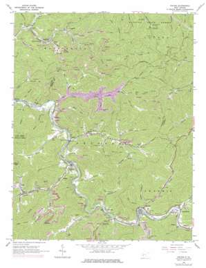
Racine Topo Map West Virginia
To zoom in, hover over the map of Racine
USGS Topo Quad 38081b6 - 1:24,000 scale
| Topo Map Name: | Racine |
| USGS Topo Quad ID: | 38081b6 |
| Print Size: | ca. 21 1/4" wide x 27" high |
| Southeast Coordinates: | 38.125° N latitude / 81.625° W longitude |
| Map Center Coordinates: | 38.1875° N latitude / 81.6875° W longitude |
| U.S. State: | WV |
| Filename: | o38081b6.jpg |
| Download Map JPG Image: | Racine topo map 1:24,000 scale |
| Map Type: | Topographic |
| Topo Series: | 7.5´ |
| Map Scale: | 1:24,000 |
| Source of Map Images: | United States Geological Survey (USGS) |
| Alternate Map Versions: |
Racine WV 1965, updated 1966 Download PDF Buy paper map Racine WV 1965, updated 1972 Download PDF Buy paper map Racine WV 1965, updated 1977 Download PDF Buy paper map Racine WV 2000, updated 2001 Download PDF Buy paper map Racine WV 2011 Download PDF Buy paper map Racine WV 2014 Download PDF Buy paper map Racine WV 2016 Download PDF Buy paper map |
1:24,000 Topo Quads surrounding Racine
> Back to 38081a1 at 1:100,000 scale
> Back to 38080a1 at 1:250,000 scale
> Back to U.S. Topo Maps home
Racine topo map: Gazetteer
Racine: Dams
Curtis Branch Dam elevation 304m 997′Racine: Parks
Drawdy Falls Roadside Park elevation 224m 734′Racine: Populated Places
Ashford elevation 198m 649′Bloomingrose elevation 207m 679′
Bradley elevation 199m 652′
Brushton elevation 200m 656′
Dartmont elevation 201m 659′
Dungriff elevation 224m 734′
Easly elevation 222m 728′
Eden elevation 208m 682′
Grippe elevation 202m 662′
Johns elevation 209m 685′
Lico elevation 203m 666′
Nellis elevation 233m 764′
Olcott elevation 213m 698′
Peytona elevation 214m 702′
Racine elevation 209m 685′
Rumble elevation 215m 705′
Sharlow elevation 210m 688′
Racine: Post Offices
Ashford Post Office elevation 198m 649′Bloomingrose Post Office elevation 209m 685′
Costa Post Office elevation 200m 656′
Nellis Post Office elevation 229m 751′
Peytona Post Office elevation 209m 685′
Racine Post Office elevation 208m 682′
Racine: Streams
Brier Branch elevation 196m 643′Brush Creek elevation 195m 639′
Brushy Branch elevation 228m 748′
Bull Creek elevation 187m 613′
Curtis Branch elevation 189m 620′
Drawdy Creek elevation 198m 649′
Dry Branch elevation 186m 610′
Falling Rock Fork elevation 234m 767′
Ferneys Branch elevation 255m 836′
Honeycamp Fork elevation 208m 682′
Indian Creek elevation 200m 656′
Left Fork Brier Creek elevation 218m 715′
Left Fork Bull Creek elevation 197m 646′
Lick Creek elevation 189m 620′
Little Rich Fork elevation 234m 767′
Mary Fork elevation 250m 820′
Meadow Fork Brier Creek elevation 215m 705′
Mikes Run elevation 189m 620′
Mill Branch elevation 201m 659′
Rich Fork elevation 227m 744′
Road Fork elevation 227m 744′
Roundbottom Creek elevation 199m 652′
Sentz Lick Branch elevation 198m 649′
Short Creek elevation 204m 669′
Spruce Fork elevation 221m 725′
Sugarcamp Fork elevation 201m 659′
Thomas Branch elevation 190m 623′
Toneys Branch elevation 205m 672′
Walker Creek elevation 225m 738′
Welch Branch elevation 187m 613′
White Oak Branch elevation 188m 616′
White Oak Creek elevation 196m 643′
Racine: Valleys
Burgess Hollow elevation 240m 787′Foster Hollow elevation 214m 702′
Holstein Hollow elevation 216m 708′
Loggy Hollow elevation 259m 849′
Longs Hollow elevation 217m 711′
Walker Hollow elevation 228m 748′
Racine digital topo map on disk
Buy this Racine topo map showing relief, roads, GPS coordinates and other geographical features, as a high-resolution digital map file on DVD:
Western Virginia & Southern West Virginia
Buy digital topo maps: Western Virginia & Southern West Virginia


