Bentree Topo Map West Virginia
To zoom in, hover over the map of Bentree
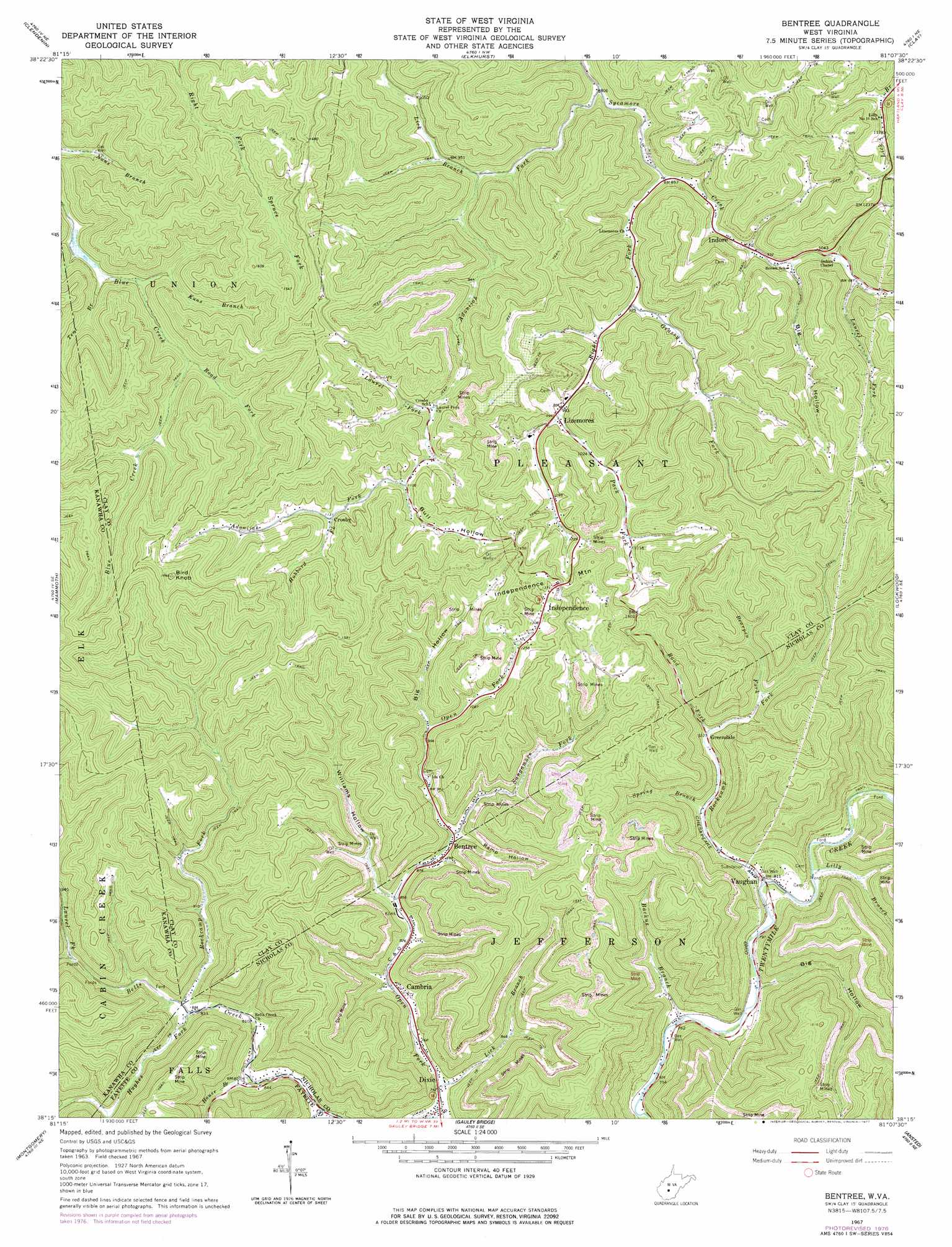
USGS Topo Quad 38081c2 - 1:24,000 scale
| Topo Map Name: | Bentree |
| USGS Topo Quad ID: | 38081c2 |
| Print Size: | ca. 21 1/4" wide x 27" high |
| Southeast Coordinates: | 38.25° N latitude / 81.125° W longitude |
| Map Center Coordinates: | 38.3125° N latitude / 81.1875° W longitude |
| U.S. State: | WV |
| Filename: | o38081c2.jpg |
| Download Map JPG Image: | Bentree topo map 1:24,000 scale |
| Map Type: | Topographic |
| Topo Series: | 7.5´ |
| Map Scale: | 1:24,000 |
| Source of Map Images: | United States Geological Survey (USGS) |
| Alternate Map Versions: |
Bentree WV 1967, updated 1968 Download PDF Buy paper map Bentree WV 1967, updated 1977 Download PDF Buy paper map Bentree WV 1996, updated 2002 Download PDF Buy paper map Bentree WV 2011 Download PDF Buy paper map Bentree WV 2014 Download PDF Buy paper map Bentree WV 2016 Download PDF Buy paper map |
1:24,000 Topo Quads surrounding Bentree
Kettle |
Clio |
Newton |
Ivydale |
Strange Creek |
Blue Creek |
Clendenin |
Elkhurst |
Clay |
Swandale |
Quick |
Mammoth |
Bentree |
Lockwood |
Gilboa |
Cedar Grove |
Montgomery |
Gauley Bridge |
Ansted |
Summersville Dam |
Eskdale |
Powellton |
Beckwith |
Fayetteville |
Winona |
> Back to 38081a1 at 1:100,000 scale
> Back to 38080a1 at 1:250,000 scale
> Back to U.S. Topo Maps home
Bentree topo map: Gazetteer
Bentree: Dams
Henderson Dam elevation 393m 1289′Union Carbide H F Club Lake Number One Dam elevation 342m 1122′
Union Carbide Lake Number Two Dam elevation 390m 1279′
Bentree: Populated Places
Adonijah elevation 322m 1056′Bentree elevation 276m 905′
Cambria elevation 242m 793′
Crosby elevation 345m 1131′
Dixie elevation 221m 725′
Greendale elevation 304m 997′
Independence elevation 418m 1371′
Indore elevation 279m 915′
Lizemores elevation 303m 994′
Vaughan elevation 247m 810′
Bentree: Post Offices
Bentree Post Office elevation 276m 905′Dixie Post Office elevation 228m 748′
Indore Post Office elevation 281m 921′
Lizemores Post Office elevation 301m 987′
Bentree: Reservoirs
Deerpond elevation 390m 1279′Henderson Lake elevation 393m 1289′
Orchard Lake elevation 342m 1122′
Bentree: Streams
Adonijah Fork elevation 244m 800′Backus Branch elevation 238m 780′
Backus Branch elevation 232m 761′
Bearpen Fork elevation 306m 1003′
Grassy Fork elevation 287m 941′
Hubbard Fork elevation 346m 1135′
Hughes Fork elevation 252m 826′
Kuns Branch elevation 297m 974′
Laurel Fork elevation 274m 898′
Laurel Fork elevation 303m 994′
Laurel Fork elevation 322m 1056′
Lick Branch elevation 270m 885′
Lick Branch elevation 255m 836′
Lilly Branch elevation 248m 813′
Open Fork elevation 221m 725′
Pack Fork elevation 303m 994′
Right Fork Sycamore Creek elevation 258m 846′
Road Fork elevation 287m 941′
Road Fork elevation 308m 1010′
Rockcamp Fork elevation 255m 836′
Rockcamp Fork elevation 243m 797′
Sangamore Fork elevation 295m 967′
Smith Branch elevation 228m 748′
Spring Branch elevation 265m 869′
Tent Branch elevation 296m 971′
Bentree: Summits
Bird Knob elevation 555m 1820′Independence Mountain elevation 487m 1597′
Bentree: Valleys
Big Hollow elevation 243m 797′Big Hollow elevation 294m 964′
Big Hollow elevation 310m 1017′
Bull Hollow elevation 352m 1154′
Ramp Hollow elevation 279m 915′
Williams Hollow elevation 262m 859′
Bentree digital topo map on disk
Buy this Bentree topo map showing relief, roads, GPS coordinates and other geographical features, as a high-resolution digital map file on DVD:
Western Virginia & Southern West Virginia
Buy digital topo maps: Western Virginia & Southern West Virginia