Mammoth Topo Map West Virginia
To zoom in, hover over the map of Mammoth
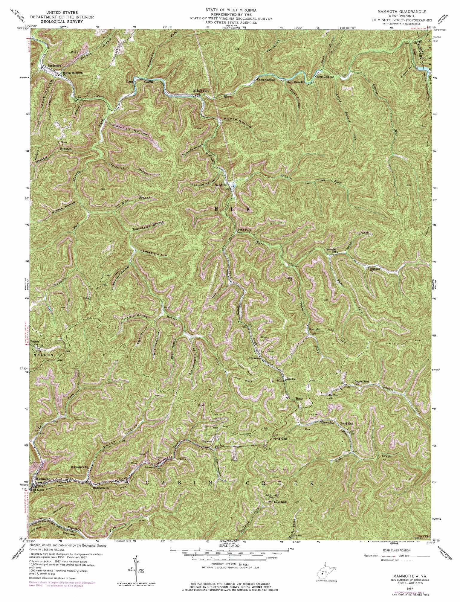
USGS Topo Quad 38081c3 - 1:24,000 scale
| Topo Map Name: | Mammoth |
| USGS Topo Quad ID: | 38081c3 |
| Print Size: | ca. 21 1/4" wide x 27" high |
| Southeast Coordinates: | 38.25° N latitude / 81.25° W longitude |
| Map Center Coordinates: | 38.3125° N latitude / 81.3125° W longitude |
| U.S. State: | WV |
| Filename: | o38081c3.jpg |
| Download Map JPG Image: | Mammoth topo map 1:24,000 scale |
| Map Type: | Topographic |
| Topo Series: | 7.5´ |
| Map Scale: | 1:24,000 |
| Source of Map Images: | United States Geological Survey (USGS) |
| Alternate Map Versions: |
Mammoth WV 1957, updated 1959 Download PDF Buy paper map Mammoth WV 1957, updated 1969 Download PDF Buy paper map Mammoth WV 1957, updated 1977 Download PDF Buy paper map Mammoth WV 1996, updated 2003 Download PDF Buy paper map Mammoth WV 2011 Download PDF Buy paper map Mammoth WV 2014 Download PDF Buy paper map Mammoth WV 2016 Download PDF Buy paper map |
1:24,000 Topo Quads surrounding Mammoth
Romance |
Kettle |
Clio |
Newton |
Ivydale |
Big Chimney |
Blue Creek |
Clendenin |
Elkhurst |
Clay |
Charleston East |
Quick |
Mammoth |
Bentree |
Lockwood |
Belle |
Cedar Grove |
Montgomery |
Gauley Bridge |
Ansted |
Sylvester |
Eskdale |
Powellton |
Beckwith |
Fayetteville |
> Back to 38081a1 at 1:100,000 scale
> Back to 38080a1 at 1:250,000 scale
> Back to U.S. Topo Maps home
Mammoth topo map: Gazetteer
Mammoth: Dams
Union Carbide Lake Number Three Dam elevation 367m 1204′Mammoth: Gaps
Low Gap elevation 410m 1345′Pond Gap elevation 435m 1427′
Mammoth: Populated Places
Acup elevation 231m 757′Amelia elevation 370m 1213′
Blakeley elevation 338m 1108′
Hitop elevation 387m 1269′
Kendalia elevation 260m 853′
Mammoth elevation 240m 787′
Middle Fork elevation 236m 774′
Morris (historical) elevation 219m 718′
Pond Fork elevation 270m 885′
Pond Gap elevation 326m 1069′
Putney elevation 369m 1210′
Sanderson elevation 219m 718′
Spangler elevation 329m 1079′
Mammoth: Post Offices
Mammoth Post Office elevation 244m 800′Pond Gap Post Office elevation 322m 1056′
Mammoth: Reservoirs
Horsehead Lake elevation 367m 1204′Mammoth: Springs
Danny Beasley Spring elevation 284m 931′Mammoth: Streams
Bear Branch elevation 253m 830′Boardtree Branch elevation 213m 698′
Campbell Fork elevation 306m 1003′
Fivemile Fork elevation 253m 830′
Gravelick Branch elevation 236m 774′
Hurricane Fork elevation 275m 902′
Laurel Run elevation 267m 875′
Left Fork Kellys Creek elevation 237m 777′
Little Laurel Run elevation 257m 843′
Middle Fork Blue Creek elevation 243m 797′
Morris Fork elevation 221m 725′
Mudlick Branch elevation 233m 764′
Nans Branch elevation 278m 912′
Nathan Branch elevation 300m 984′
Oil Well Branch elevation 259m 849′
Pond Fork elevation 271m 889′
Rockcamp Fork elevation 230m 754′
Sandlick Branch elevation 214m 702′
Shirkey Branch elevation 232m 761′
Spangler Fork elevation 285m 935′
Spruce Fork elevation 297m 974′
Spruce Fork elevation 278m 912′
Sugarcamp Branch elevation 267m 875′
Turner Fork elevation 258m 846′
Mammoth: Valleys
Bear Hollow elevation 308m 1010′Belcher Hollow elevation 241m 790′
Blue Star Hollow elevation 298m 977′
Coral Hollow elevation 258m 846′
Deadening Hollow elevation 311m 1020′
Durham Hollow elevation 289m 948′
Egypt Hollow elevation 309m 1013′
Goodman Hollow elevation 267m 875′
Goose Hollow elevation 262m 859′
Hidden Hollow elevation 264m 866′
Hillfield Hollow elevation 290m 951′
James Hollow elevation 276m 905′
Jim Hollow elevation 306m 1003′
Joes Hollow elevation 220m 721′
McBride Hollow elevation 265m 869′
Moore Hollow elevation 243m 797′
Mudlick Hollow elevation 308m 1010′
Panther Hollow elevation 258m 846′
Rich Hollow elevation 367m 1204′
Slabcamp Hollow elevation 265m 869′
Mammoth digital topo map on disk
Buy this Mammoth topo map showing relief, roads, GPS coordinates and other geographical features, as a high-resolution digital map file on DVD:
Western Virginia & Southern West Virginia
Buy digital topo maps: Western Virginia & Southern West Virginia