Quick Topo Map West Virginia
To zoom in, hover over the map of Quick
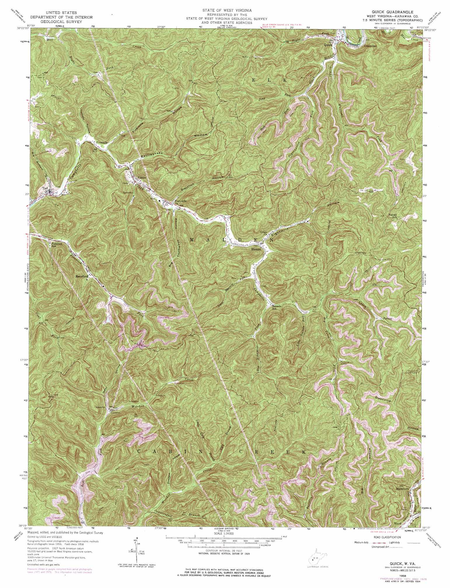
USGS Topo Quad 38081c4 - 1:24,000 scale
| Topo Map Name: | Quick |
| USGS Topo Quad ID: | 38081c4 |
| Print Size: | ca. 21 1/4" wide x 27" high |
| Southeast Coordinates: | 38.25° N latitude / 81.375° W longitude |
| Map Center Coordinates: | 38.3125° N latitude / 81.4375° W longitude |
| U.S. State: | WV |
| Filename: | o38081c4.jpg |
| Download Map JPG Image: | Quick topo map 1:24,000 scale |
| Map Type: | Topographic |
| Topo Series: | 7.5´ |
| Map Scale: | 1:24,000 |
| Source of Map Images: | United States Geological Survey (USGS) |
| Alternate Map Versions: |
Quick WV 1958, updated 1959 Download PDF Buy paper map Quick WV 1958, updated 1969 Download PDF Buy paper map Quick WV 1958, updated 1973 Download PDF Buy paper map Quick WV 1958, updated 1977 Download PDF Buy paper map Quick WV 2000, updated 2001 Download PDF Buy paper map Quick WV 2011 Download PDF Buy paper map Quick WV 2014 Download PDF Buy paper map Quick WV 2016 Download PDF Buy paper map |
1:24,000 Topo Quads surrounding Quick
Sissonville |
Romance |
Kettle |
Clio |
Newton |
Pocatalico |
Big Chimney |
Blue Creek |
Clendenin |
Elkhurst |
Charleston West |
Charleston East |
Quick |
Mammoth |
Bentree |
Racine |
Belle |
Cedar Grove |
Montgomery |
Gauley Bridge |
Williams Mountain |
Sylvester |
Eskdale |
Powellton |
Beckwith |
> Back to 38081a1 at 1:100,000 scale
> Back to 38080a1 at 1:250,000 scale
> Back to U.S. Topo Maps home
Quick topo map: Gazetteer
Quick: Populated Places
Annfred elevation 273m 895′Blount elevation 241m 790′
Cinco elevation 212m 695′
Coalridge elevation 210m 688′
Fivemile elevation 205m 672′
Quick elevation 208m 682′
Rensford elevation 234m 767′
Tad elevation 198m 649′
Quick: Post Offices
Blount Post Office elevation 239m 784′Quick: Streams
Big Ninemile Fork elevation 270m 885′Big Tenmile Fork elevation 281m 921′
Book Fork elevation 255m 836′
Cline Branch elevation 197m 646′
Counterfeit Branch elevation 236m 774′
Eightmile Fork elevation 242m 793′
Fivemile Fork elevation 206m 675′
Fivemile Fork elevation 228m 748′
Jims Fork elevation 234m 767′
Little Ninemile Fork elevation 248m 813′
Little Tenmile Fork elevation 274m 898′
Little Ugly Branch elevation 285m 935′
Pigeonroost Fork elevation 235m 770′
Right Fork Mill Creek elevation 243m 797′
Schoolhouse Fork elevation 214m 702′
Slack Branch elevation 206m 675′
Slatelick Run elevation 219m 718′
Ugly Branch elevation 274m 898′
Whiteoak Fork elevation 214m 702′
Quick: Summits
Mount Desert elevation 491m 1610′Quick: Valleys
Big Bottom Hollow elevation 207m 679′Big Thompson Hollow elevation 222m 728′
Eightmile Hollow elevation 243m 797′
Fivemile Hollow elevation 209m 685′
Hunt Hollow elevation 274m 898′
Rattlesnake Hollow elevation 212m 695′
Slatelick Hollow elevation 224m 734′
Sprucepine Hollow elevation 213m 698′
Steepgut Hollow elevation 251m 823′
Tackett Hollow elevation 208m 682′
Quick digital topo map on disk
Buy this Quick topo map showing relief, roads, GPS coordinates and other geographical features, as a high-resolution digital map file on DVD:
Western Virginia & Southern West Virginia
Buy digital topo maps: Western Virginia & Southern West Virginia