Garretts Bend Topo Map West Virginia
To zoom in, hover over the map of Garretts Bend
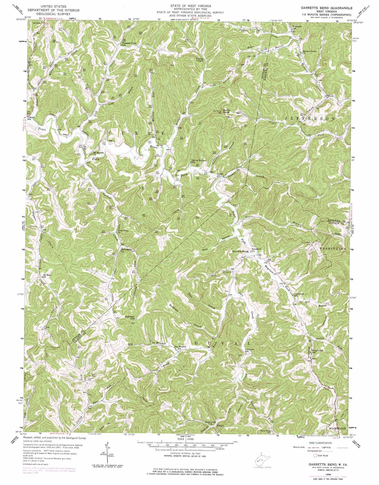
USGS Topo Quad 38081c8 - 1:24,000 scale
| Topo Map Name: | Garretts Bend |
| USGS Topo Quad ID: | 38081c8 |
| Print Size: | ca. 21 1/4" wide x 27" high |
| Southeast Coordinates: | 38.25° N latitude / 81.875° W longitude |
| Map Center Coordinates: | 38.3125° N latitude / 81.9375° W longitude |
| U.S. State: | WV |
| Filename: | o38081c8.jpg |
| Download Map JPG Image: | Garretts Bend topo map 1:24,000 scale |
| Map Type: | Topographic |
| Topo Series: | 7.5´ |
| Map Scale: | 1:24,000 |
| Source of Map Images: | United States Geological Survey (USGS) |
| Alternate Map Versions: |
Garretts Bend WV 1958, updated 1960 Download PDF Buy paper map Garretts Bend WV 1958, updated 1965 Download PDF Buy paper map Garretts Bend WV 1958, updated 1973 Download PDF Buy paper map Garretts Bend WV 1958, updated 1978 Download PDF Buy paper map Garretts Bend WV 2011 Download PDF Buy paper map Garretts Bend WV 2014 Download PDF Buy paper map Garretts Bend WV 2016 Download PDF Buy paper map |
1:24,000 Topo Quads surrounding Garretts Bend
Glenwood |
Mount Olive |
Winfield |
Bancroft |
Sissonville |
Milton |
Hurricane |
Scott Depot |
Saint Albans |
Pocatalico |
West Hamlin |
Hamlin |
Garretts Bend |
Alum Creek |
Charleston West |
Branchland |
Hager |
Griffithsville |
Julian |
Racine |
Ranger |
Big Creek |
Mud |
Madison |
Williams Mountain |
> Back to 38081a1 at 1:100,000 scale
> Back to 38080a1 at 1:250,000 scale
> Back to U.S. Topo Maps home
Garretts Bend topo map: Gazetteer
Garretts Bend: Parks
Hilbert Wildlife Management Area elevation 246m 807′Garretts Bend: Populated Places
Garretts Bend elevation 209m 685′Tango elevation 226m 741′
Garretts Bend: Streams
Adkins Fork elevation 192m 629′Bridge Creek elevation 197m 646′
Bryan Branch elevation 200m 656′
Buck Branch elevation 206m 675′
Donley Fork elevation 225m 738′
Dry Branch elevation 220m 721′
Hayzlett Fork elevation 207m 679′
Joes Creek elevation 209m 685′
Kellys Creek elevation 197m 646′
Laurel Fork elevation 219m 718′
Lefthand Fork Turkey Creek elevation 207m 679′
Lick Branch elevation 211m 692′
Lick Creek elevation 194m 636′
Long Branch elevation 197m 646′
Martin Run elevation 199m 652′
Road Fork elevation 209m 685′
Rockhouse Branch elevation 213m 698′
Tango Branch elevation 226m 741′
Toms Branch elevation 211m 692′
Tony Branch elevation 205m 672′
Trace Branch elevation 204m 669′
Trace Creek elevation 193m 633′
Turkey Creek elevation 195m 639′
Twomile Branch elevation 202m 662′
Garretts Bend: Summits
Rocky Knob elevation 354m 1161′Garretts Bend: Valleys
Flint Hollow elevation 215m 705′Raccoon Hollow elevation 202m 662′
Garretts Bend digital topo map on disk
Buy this Garretts Bend topo map showing relief, roads, GPS coordinates and other geographical features, as a high-resolution digital map file on DVD:
Western Virginia & Southern West Virginia
Buy digital topo maps: Western Virginia & Southern West Virginia