Clendenin Topo Map West Virginia
To zoom in, hover over the map of Clendenin
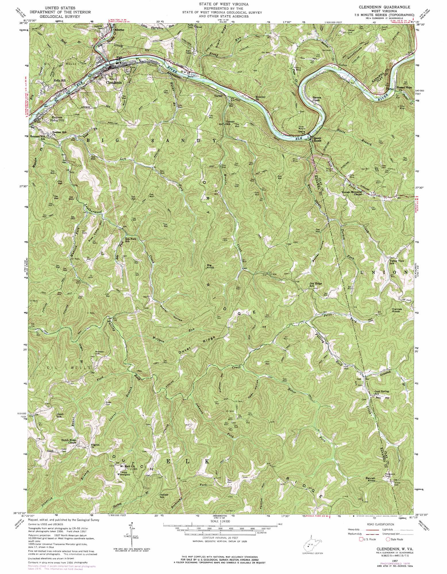
USGS Topo Quad 38081d3 - 1:24,000 scale
| Topo Map Name: | Clendenin |
| USGS Topo Quad ID: | 38081d3 |
| Print Size: | ca. 21 1/4" wide x 27" high |
| Southeast Coordinates: | 38.375° N latitude / 81.25° W longitude |
| Map Center Coordinates: | 38.4375° N latitude / 81.3125° W longitude |
| U.S. State: | WV |
| Filename: | o38081d3.jpg |
| Download Map JPG Image: | Clendenin topo map 1:24,000 scale |
| Map Type: | Topographic |
| Topo Series: | 7.5´ |
| Map Scale: | 1:24,000 |
| Source of Map Images: | United States Geological Survey (USGS) |
| Alternate Map Versions: |
Clendenin WV 1957, updated 1959 Download PDF Buy paper map Clendenin WV 1957, updated 1977 Download PDF Buy paper map Clendenin WV 2011 Download PDF Buy paper map Clendenin WV 2014 Download PDF Buy paper map Clendenin WV 2016 Download PDF Buy paper map |
1:24,000 Topo Quads surrounding Clendenin
Kentuck |
Walton |
Looneyville |
Tariff |
Chloe |
Romance |
Kettle |
Clio |
Newton |
Ivydale |
Big Chimney |
Blue Creek |
Clendenin |
Elkhurst |
Clay |
Charleston East |
Quick |
Mammoth |
Bentree |
Lockwood |
Belle |
Cedar Grove |
Montgomery |
Gauley Bridge |
Ansted |
> Back to 38081a1 at 1:100,000 scale
> Back to 38080a1 at 1:250,000 scale
> Back to U.S. Topo Maps home
Clendenin topo map: Gazetteer
Clendenin: Bridges
Queen Shoals Bridge elevation 186m 610′Clendenin: Parks
Morris Creek Wildlife Management Area elevation 335m 1099′Clendenin: Populated Places
Apgah (historical) elevation 393m 1289′Barren Creek elevation 194m 636′
Clendenin elevation 190m 623′
Corton elevation 188m 616′
Gazil (historical) elevation 427m 1400′
Heatherman (historical) elevation 191m 626′
Kelly Hill elevation 189m 620′
Odell elevation 360m 1181′
Osborne elevation 194m 636′
Porter elevation 192m 629′
Queen Shoals elevation 196m 643′
Reamer elevation 193m 633′
Rosina (historical) elevation 308m 1010′
Turner elevation 213m 698′
Clendenin: Post Offices
Corton Post Office elevation 194m 636′Clendenin: Ridges
Dry Ridge elevation 394m 1292′Dutch Ridge elevation 438m 1437′
Duval Ridge elevation 436m 1430′
Clendenin: Streams
Barren Creek elevation 188m 616′Big Creek elevation 181m 593′
Big Sandy Creek elevation 181m 593′
Broad Run elevation 183m 600′
Burke Branch elevation 183m 600′
Eds Fork elevation 231m 757′
Evans Fork elevation 232m 761′
Grasslick Branch elevation 300m 984′
Harts Branch elevation 186m 610′
Horse Fork elevation 260m 853′
Johnson Fork elevation 250m 820′
Laurel Branch elevation 235m 770′
Left Fork Leatherwood Creek elevation 190m 623′
Left Fork Queen Shoals Creek elevation 193m 633′
Malcolm Fork elevation 193m 633′
Morris Creek elevation 183m 600′
Mudlick Fork elevation 214m 702′
Oxyer Branch elevation 223m 731′
Petes Fork elevation 287m 941′
Porter Creek elevation 186m 610′
Pups Creek elevation 195m 639′
Queen Shoals Creek elevation 185m 606′
Sand Branch elevation 184m 603′
Turkey Fork elevation 240m 787′
Vent Fork elevation 201m 659′
Wolfpen Run elevation 228m 748′
Clendenin: Summits
Beulah Knob elevation 462m 1515′Big Knob elevation 437m 1433′
Carnes Knob elevation 443m 1453′
Clendenin: Valleys
Booker Hollow elevation 234m 767′Huffman Hollow elevation 260m 853′
Mill Hollow elevation 182m 597′
Open Hollow elevation 270m 885′
Poplar Hollow elevation 270m 885′
Sam Hollow elevation 304m 997′
Schoolhouse Hollow elevation 194m 636′
Slab Camp Hollow elevation 225m 738′
Clendenin digital topo map on disk
Buy this Clendenin topo map showing relief, roads, GPS coordinates and other geographical features, as a high-resolution digital map file on DVD:
Western Virginia & Southern West Virginia
Buy digital topo maps: Western Virginia & Southern West Virginia