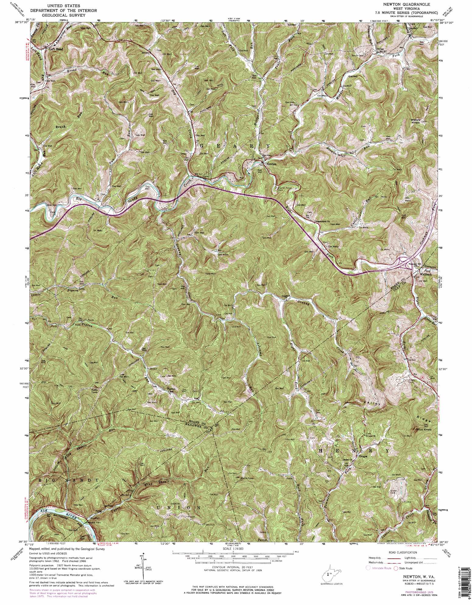
Newton Topo Map West Virginia
To zoom in, hover over the map of Newton
USGS Topo Quad 38081e2 - 1:24,000 scale
| Topo Map Name: | Newton |
| USGS Topo Quad ID: | 38081e2 |
| Print Size: | ca. 21 1/4" wide x 27" high |
| Southeast Coordinates: | 38.5° N latitude / 81.125° W longitude |
| Map Center Coordinates: | 38.5625° N latitude / 81.1875° W longitude |
| U.S. State: | WV |
| Filename: | o38081e2.jpg |
| Download Map JPG Image: | Newton topo map 1:24,000 scale |
| Map Type: | Topographic |
| Topo Series: | 7.5´ |
| Map Scale: | 1:24,000 |
| Source of Map Images: | United States Geological Survey (USGS) |
| Alternate Map Versions: |
Newton WV 1966, updated 1968 Download PDF Buy paper map Newton WV 1966, updated 1976 Download PDF Buy paper map Newton WV 2011 Download PDF Buy paper map Newton WV 2014 Download PDF Buy paper map Newton WV 2016 Download PDF Buy paper map |
1:24,000 Topo Quads surrounding Newton
Peniel |
Spencer |
Arnoldsburg |
Millstone |
Normantown |
Walton |
Looneyville |
Tariff |
Chloe |
Rosedale |
Kettle |
Clio |
Newton |
Ivydale |
Strange Creek |
Blue Creek |
Clendenin |
Elkhurst |
Clay |
Swandale |
Quick |
Mammoth |
Bentree |
Lockwood |
Gilboa |
> Back to 38081e1 at 1:100,000 scale
> Back to 38080a1 at 1:250,000 scale
> Back to U.S. Topo Maps home
Newton topo map: Gazetteer
Newton: Crossings
Interchange 34 elevation 239m 784′Newton: Parks
Wallback Wildlife Management Area elevation 332m 1089′Newton: Populated Places
Barton (historical) elevation 279m 915′Bloomington (historical) elevation 211m 692′
King elevation 201m 659′
Newton elevation 219m 718′
Ovapa elevation 267m 875′
Pigeon elevation 266m 872′
Rand (historical) elevation 197m 646′
Uler elevation 232m 761′
Wallback elevation 233m 764′
Newton: Post Offices
Left Hand Post Office elevation 227m 744′Newton Post Office elevation 261m 856′
Ovapa Post Office elevation 266m 872′
Uler Post Office elevation 232m 761′
Wallback Post Office elevation 245m 803′
Newton: Ridges
Valley Ridge elevation 422m 1384′Newton: Springs
Trudice Carper Spring elevation 336m 1102′Newton: Streams
Anthony Run elevation 237m 777′Ashcamp Run elevation 235m 770′
Ashleycamp Run elevation 222m 728′
Bee Run elevation 237m 777′
Blowntimber Run elevation 220m 721′
Broad Run elevation 219m 718′
Brush Run elevation 214m 702′
Camp Run elevation 237m 777′
Cookman Fork elevation 233m 764′
Cutoff Run elevation 224m 734′
Dog Creek elevation 212m 695′
Granny Creek elevation 211m 692′
Hansford Fork elevation 255m 836′
Hollywood Run elevation 219m 718′
King Shoals Run elevation 188m 616′
Left Fork Hollywood Run elevation 228m 748′
Middle Fork Big Sandy Creek elevation 217m 711′
Right Fork Big Sandy Creek elevation 218m 715′
Right Fork Granny Creek elevation 248m 813′
Simmons Run elevation 239m 784′
Summers Fork elevation 234m 767′
Trace Fork elevation 234m 767′
Two Run elevation 211m 692′
Upper King Shoals Run elevation 190m 623′
Valley Fork elevation 258m 846′
Newton: Summits
Pilot Knob elevation 487m 1597′Weedy Knob elevation 447m 1466′
Newton digital topo map on disk
Buy this Newton topo map showing relief, roads, GPS coordinates and other geographical features, as a high-resolution digital map file on DVD:
Western Virginia & Southern West Virginia
Buy digital topo maps: Western Virginia & Southern West Virginia