Sissonville Topo Map West Virginia
To zoom in, hover over the map of Sissonville
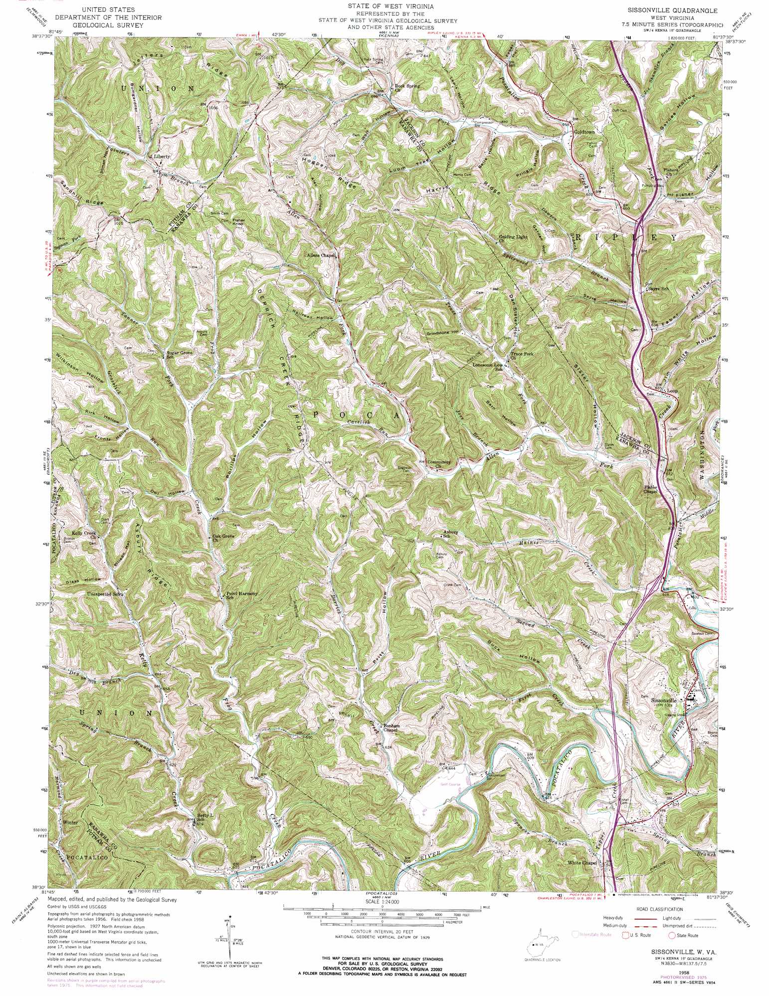
USGS Topo Quad 38081e6 - 1:24,000 scale
| Topo Map Name: | Sissonville |
| USGS Topo Quad ID: | 38081e6 |
| Print Size: | ca. 21 1/4" wide x 27" high |
| Southeast Coordinates: | 38.5° N latitude / 81.625° W longitude |
| Map Center Coordinates: | 38.5625° N latitude / 81.6875° W longitude |
| U.S. State: | WV |
| Filename: | o38081e6.jpg |
| Download Map JPG Image: | Sissonville topo map 1:24,000 scale |
| Map Type: | Topographic |
| Topo Series: | 7.5´ |
| Map Scale: | 1:24,000 |
| Source of Map Images: | United States Geological Survey (USGS) |
| Alternate Map Versions: |
Sissonville WV 1958, updated 1959 Download PDF Buy paper map Sissonville WV 1958, updated 1969 Download PDF Buy paper map Sissonville WV 1958, updated 1976 Download PDF Buy paper map Sissonville WV 1958, updated 1976 Download PDF Buy paper map Sissonville WV 2000, updated 2001 Download PDF Buy paper map Sissonville WV 2011 Download PDF Buy paper map Sissonville WV 2014 Download PDF Buy paper map Sissonville WV 2016 Download PDF Buy paper map |
1:24,000 Topo Quads surrounding Sissonville
Mount Alto |
Cottageville |
Ripley |
Gay |
Peniel |
Robertsburg |
Elmwood |
Kenna |
Kentuck |
Walton |
Winfield |
Bancroft |
Sissonville |
Romance |
Kettle |
Scott Depot |
Saint Albans |
Pocatalico |
Big Chimney |
Blue Creek |
Garretts Bend |
Alum Creek |
Charleston West |
Charleston East |
Quick |
> Back to 38081e1 at 1:100,000 scale
> Back to 38080a1 at 1:250,000 scale
> Back to U.S. Topo Maps home
Sissonville topo map: Gazetteer
Sissonville: Crossings
Interchange 114 elevation 187m 613′Interchange 116 elevation 190m 623′
Interchange 119 elevation 201m 659′
Sissonville: Populated Places
Goldtown elevation 202m 662′Liberty elevation 236m 774′
Loop elevation 194m 636′
Millertown elevation 197m 646′
Sissonville elevation 190m 623′
White Chapel elevation 189m 620′
Winter elevation 215m 705′
Sissonville: Post Offices
Liberty Post Office elevation 236m 774′Sissonville: Ridges
Asbury Ridge elevation 323m 1059′Derrick Creek Ridge elevation 309m 1013′
Harris Ridge elevation 299m 980′
Hogpen Ridge elevation 313m 1026′
Jeffers Ridge elevation 314m 1030′
Sissonville: Springs
Glenn Mallett Spring elevation 201m 659′John Bailey Spring elevation 318m 1043′
Otis Bumgardner Spring elevation 249m 816′
Sissonville: Streams
Allen Fork elevation 189m 620′Cavelick Run elevation 201m 659′
Dawson Branch elevation 206m 675′
Derrick Creek elevation 183m 600′
Dog Fork elevation 204m 669′
Dry Branch elevation 200m 656′
Dudden Fork elevation 199m 652′
First Creek elevation 181m 593′
Frog Creek elevation 179m 587′
Grapevine Creek elevation 183m 600′
Grasslick Run elevation 198m 649′
Haines Creek elevation 185m 606′
Joe Shamblen Branch elevation 199m 652′
Joes Branch elevation 194m 636′
Kelly Creek elevation 175m 574′
Middle Fork elevation 186m 610′
Pocatalico Creek elevation 191m 626′
Second Creek elevation 182m 597′
Spencer Branch elevation 188m 616′
Spicewood Branch elevation 195m 639′
Spring Branch elevation 183m 600′
Spring Branch elevation 190m 623′
Tanner Fork elevation 203m 666′
Trace Fork elevation 194m 636′
Tupper Creek elevation 180m 590′
Sissonville: Summits
Fisher Knob elevation 331m 1085′Sissonville: Valleys
Alec Hollow elevation 238m 780′Barn Hollow elevation 197m 646′
Bells Hollow elevation 204m 669′
Buck Hollow elevation 197m 646′
Bumgardner Hollow elevation 233m 764′
Dan Slater Hollow elevation 207m 679′
Ellison Hollow elevation 219m 718′
Faber Hollow elevation 196m 643′
Faber Hollow elevation 203m 666′
Fisher Hollow elevation 198m 649′
Frontz Hollow elevation 213m 698′
Garden Hollow elevation 217m 711′
Garnes Hollow elevation 201m 659′
Glass Hollow elevation 218m 715′
Grindstone Hollow elevation 220m 721′
Jim Lewis Hollow elevation 204m 669′
Jim White Hollow elevation 194m 636′
Kirk Hollow elevation 214m 702′
Loom Tree Hollow elevation 203m 666′
Owl Hollow elevation 211m 692′
Phillips Hollow elevation 197m 646′
Pringle Hollow elevation 200m 656′
Pritt Hollow elevation 199m 652′
Railroad Hollow elevation 220m 721′
Sayre Hollow elevation 196m 643′
Sillman Hollow elevation 229m 751′
Slater Hollow elevation 194m 636′
Wilkinson Hollow elevation 222m 728′
Wolf Hollow elevation 206m 675′
Sissonville digital topo map on disk
Buy this Sissonville topo map showing relief, roads, GPS coordinates and other geographical features, as a high-resolution digital map file on DVD:
Western Virginia & Southern West Virginia
Buy digital topo maps: Western Virginia & Southern West Virginia