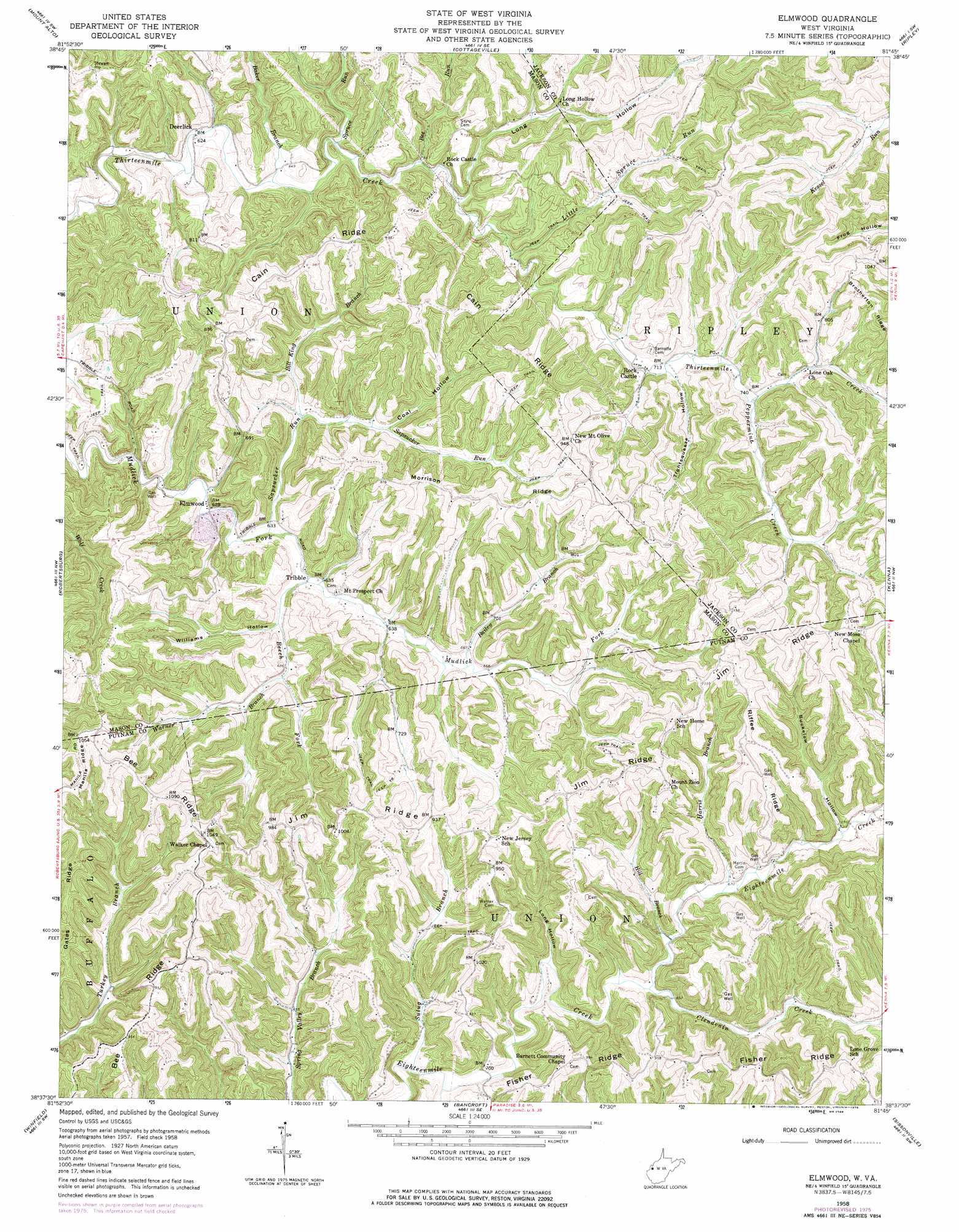
Elmwood Topo Map West Virginia
To zoom in, hover over the map of Elmwood
USGS Topo Quad 38081f7 - 1:24,000 scale
| Topo Map Name: | Elmwood |
| USGS Topo Quad ID: | 38081f7 |
| Print Size: | ca. 21 1/4" wide x 27" high |
| Southeast Coordinates: | 38.625° N latitude / 81.75° W longitude |
| Map Center Coordinates: | 38.6875° N latitude / 81.8125° W longitude |
| U.S. State: | WV |
| Filename: | o38081f7.jpg |
| Download Map JPG Image: | Elmwood topo map 1:24,000 scale |
| Map Type: | Topographic |
| Topo Series: | 7.5´ |
| Map Scale: | 1:24,000 |
| Source of Map Images: | United States Geological Survey (USGS) |
| Alternate Map Versions: |
Elmwood WV 1958, updated 1960 Download PDF Buy paper map Elmwood WV 1958, updated 1976 Download PDF Buy paper map Elmwood WV 2011 Download PDF Buy paper map Elmwood WV 2014 Download PDF Buy paper map Elmwood WV 2016 Download PDF Buy paper map |
1:24,000 Topo Quads surrounding Elmwood
Cheshire |
New Haven |
Ravenswood |
Sandyville |
Liverpool |
Beech Hill |
Mount Alto |
Cottageville |
Ripley |
Gay |
Arlee |
Robertsburg |
Elmwood |
Kenna |
Kentuck |
Mount Olive |
Winfield |
Bancroft |
Sissonville |
Romance |
Hurricane |
Scott Depot |
Saint Albans |
Pocatalico |
Big Chimney |
> Back to 38081e1 at 1:100,000 scale
> Back to 38080a1 at 1:250,000 scale
> Back to U.S. Topo Maps home
Elmwood topo map: Gazetteer
Elmwood: Populated Places
Elmwood elevation 190m 623′Tribble elevation 189m 620′
Elmwood: Ridges
Bee Ridge elevation 311m 1020′Cain Ridge elevation 290m 951′
Fisher Ridge elevation 313m 1026′
Jim Ridge elevation 315m 1033′
Morrison Ridge elevation 314m 1030′
Riffee Ridge elevation 321m 1053′
Elmwood: Springs
Arthur Barnett Spring elevation 288m 944′Cobb Spring elevation 271m 889′
Early Castro Spring elevation 278m 912′
Kenneth Asbury Spring elevation 300m 984′
Kenneth Asbury Spring elevation 252m 826′
Pennington Spring elevation 192m 629′
Elmwood: Streams
Bailey Branch elevation 201m 659′Baker Branch elevation 187m 613′
Bee Run elevation 196m 643′
Beech Fork elevation 189m 620′
Bill King Branch elevation 195m 639′
Cherry Fork elevation 190m 623′
Clendenin Creek elevation 196m 643′
Harris Branch elevation 207m 679′
Hill Branch elevation 199m 652′
Left Fork Clendenin Creek elevation 211m 692′
Little Spruce Run elevation 203m 666′
Peppermint Creek elevation 221m 725′
Right Fork Clendenin Creek elevation 211m 692′
Sapsucker Run elevation 187m 613′
Spruce Run elevation 193m 633′
Sulug Branch elevation 202m 662′
Warner Branch elevation 202m 662′
Elmwood: Valleys
Buckelew Hollow elevation 209m 685′Coal Hollow elevation 205m 672′
Long Hollow elevation 196m 643′
Long Hollow elevation 196m 643′
Tightsqueeze Hollow elevation 217m 711′
Williams Hollow elevation 197m 646′
Elmwood digital topo map on disk
Buy this Elmwood topo map showing relief, roads, GPS coordinates and other geographical features, as a high-resolution digital map file on DVD:
Western Virginia & Southern West Virginia
Buy digital topo maps: Western Virginia & Southern West Virginia