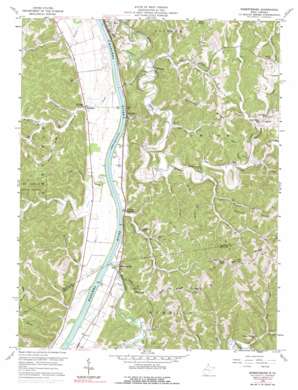
Robertsburg Topo Map West Virginia
To zoom in, hover over the map of Robertsburg
USGS Topo Quad 38081f8 - 1:24,000 scale
| Topo Map Name: | Robertsburg |
| USGS Topo Quad ID: | 38081f8 |
| Print Size: | ca. 21 1/4" wide x 27" high |
| Southeast Coordinates: | 38.625° N latitude / 81.875° W longitude |
| Map Center Coordinates: | 38.6875° N latitude / 81.9375° W longitude |
| U.S. State: | WV |
| Filename: | o38081f8.jpg |
| Download Map JPG Image: | Robertsburg topo map 1:24,000 scale |
| Map Type: | Topographic |
| Topo Series: | 7.5´ |
| Map Scale: | 1:24,000 |
| Source of Map Images: | United States Geological Survey (USGS) |
| Alternate Map Versions: |
Robertsburg WV 1958, updated 1960 Download PDF Buy paper map Robertsburg WV 1958, updated 1977 Download PDF Buy paper map Robertsburg WV 1958, updated 1991 Download PDF Buy paper map Robertsburg WV 1977, updated 1979 Download PDF Buy paper map Robertsburg WV 2011 Download PDF Buy paper map Robertsburg WV 2014 Download PDF Buy paper map Robertsburg WV 2016 Download PDF Buy paper map |
1:24,000 Topo Quads surrounding Robertsburg
> Back to 38081e1 at 1:100,000 scale
> Back to 38080a1 at 1:250,000 scale
> Back to U.S. Topo Maps home
Robertsburg topo map: Gazetteer
Robertsburg: Airports
Leon Airport elevation 172m 564′Robertsburg: Populated Places
Arbuckle elevation 179m 587′Capehart elevation 181m 593′
Grimms Landing elevation 174m 570′
McCansland (historical) elevation 176m 577′
North Park elevation 174m 570′
Robertsburg elevation 177m 580′
Southside elevation 172m 564′
Waterloo elevation 167m 547′
Robertsburg: Post Offices
Arbuckle Post Office elevation 178m 583′Grimms Landing Post Office elevation 174m 570′
Robertsburg Post Office elevation 176m 577′
Robertsburg: Ridges
Buffalo Ridge elevation 287m 941′Calispell Ridge elevation 277m 908′
Hudson Ridge elevation 256m 839′
Manila Ridge elevation 293m 961′
Wildcat Ridge elevation 283m 928′
Robertsburg: Springs
Bennett Spring elevation 176m 577′Bennett Spring elevation 196m 643′
Densil Jividen Spring elevation 259m 849′
Ernest Tucker Spring elevation 200m 656′
Haynes Spring elevation 282m 925′
Hulbert Spring elevation 225m 738′
John Lloyd Spring elevation 173m 567′
Robertsburg: Streams
Arbuckle Creek elevation 165m 541′Buzzard Creek elevation 177m 580′
Cabin Creek elevation 172m 564′
Daves Branch elevation 176m 577′
Eighteenmile Creek elevation 166m 544′
Left Fork Turkey Branch elevation 183m 600′
Little Buzzard Creek elevation 182m 597′
Little Sixteenmile Creek elevation 164m 538′
McCausland Run elevation 165m 541′
Mudlick Fork elevation 177m 580′
Otter Branch elevation 167m 547′
Poplar Fork elevation 177m 580′
Rocky Fork elevation 179m 587′
Rocky Fork elevation 168m 551′
Shady Fork elevation 175m 574′
Sixteenmile Creek elevation 165m 541′
Tom Allen Creek elevation 169m 554′
Turkey Branch elevation 177m 580′
Wolf Creek elevation 179m 587′
Yeager Fork elevation 180m 590′
Robertsburg: Summits
Parker Hill elevation 290m 951′Robertsburg: Valleys
Boardman Hollow elevation 173m 567′Opossum Hollow elevation 188m 616′
Slaty Hollow elevation 165m 541′
Robertsburg digital topo map on disk
Buy this Robertsburg topo map showing relief, roads, GPS coordinates and other geographical features, as a high-resolution digital map file on DVD:
Western Virginia & Southern West Virginia
Buy digital topo maps: Western Virginia & Southern West Virginia


