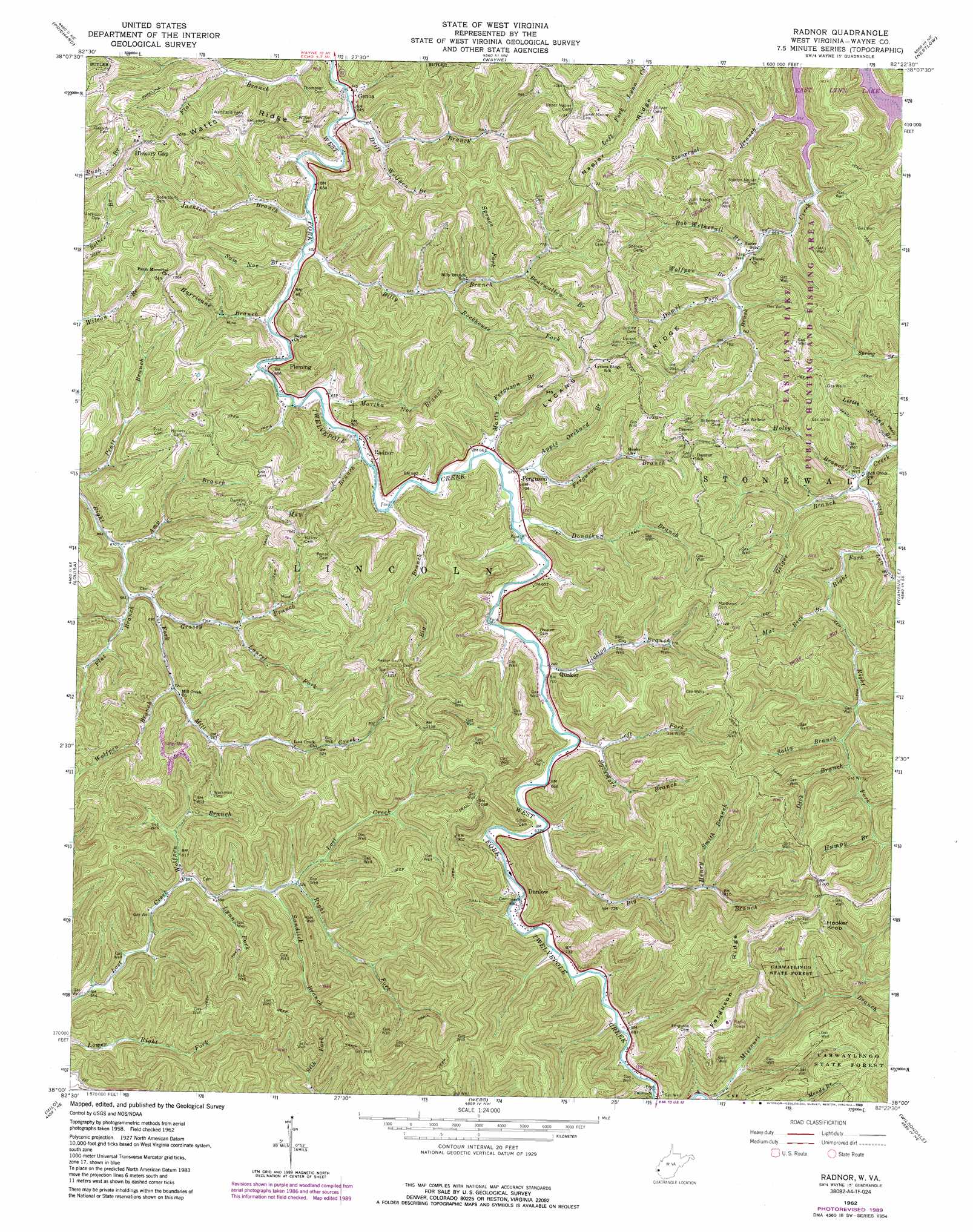
Radnor Topo Map West Virginia
To zoom in, hover over the map of Radnor
USGS Topo Quad 38082a4 - 1:24,000 scale
| Topo Map Name: | Radnor |
| USGS Topo Quad ID: | 38082a4 |
| Print Size: | ca. 21 1/4" wide x 27" high |
| Southeast Coordinates: | 38° N latitude / 82.375° W longitude |
| Map Center Coordinates: | 38.0625° N latitude / 82.4375° W longitude |
| U.S. State: | WV |
| Filename: | o38082a4.jpg |
| Download Map JPG Image: | Radnor topo map 1:24,000 scale |
| Map Type: | Topographic |
| Topo Series: | 7.5´ |
| Map Scale: | 1:24,000 |
| Source of Map Images: | United States Geological Survey (USGS) |
| Alternate Map Versions: |
Radnor WV 1962, updated 1964 Download PDF Buy paper map Radnor WV 1962, updated 1977 Download PDF Buy paper map Radnor WV 1962, updated 1989 Download PDF Buy paper map Radnor WV 2011 Download PDF Buy paper map Radnor WV 2014 Download PDF Buy paper map Radnor WV 2016 Download PDF Buy paper map |
1:24,000 Topo Quads surrounding Radnor
Boltsfork |
Burnaugh |
Lavalette |
Winslow |
West Hamlin |
Fallsburg |
Prichard |
Wayne |
Nestlow |
Branchland |
Adams |
Louisa |
Radnor |
Kiahsville |
Ranger |
Richardson |
Milo |
Webb |
Wilsondale |
Trace |
Offutt |
Inez |
Kermit |
Naugatuck |
Myrtle |
> Back to 38082a1 at 1:100,000 scale
> Back to 38082a1 at 1:250,000 scale
> Back to U.S. Topo Maps home
Radnor topo map: Gazetteer
Radnor: Populated Places
Dunlow elevation 211m 692′Ferguson elevation 205m 672′
Fleming elevation 209m 685′
Genoa elevation 196m 643′
Quaker elevation 214m 702′
Radnor elevation 205m 672′
Radnor: Ridges
Ferguson Ridge elevation 388m 1272′Lycans Ridge elevation 339m 1112′
Napier Ridge elevation 342m 1122′
Watts Ridge elevation 333m 1092′
Radnor: Streams
Amp Branch elevation 202m 662′Apple Orchard Branch elevation 204m 669′
Bearwallow Branch elevation 226m 741′
Big Branch elevation 198m 649′
Big Branch elevation 208m 682′
Billy Branch elevation 195m 639′
Bob Wetherall Branch elevation 213m 698′
Damel Fork elevation 218m 715′
Dick Branch elevation 246m 807′
Donathan Branch elevation 200m 656′
Drift Branch elevation 191m 626′
Ferguson Branch elevation 199m 652′
Flat Branch elevation 205m 672′
Geiger Branch elevation 206m 675′
Grassy Branch elevation 208m 682′
Henry Smith Branch elevation 239m 784′
Holly Branch elevation 205m 672′
Humpy Branch elevation 261m 856′
Hurricane Branch elevation 197m 646′
Jackson Branch elevation 196m 643′
Laurel Fork elevation 221m 725′
Left Fork Rich Creek elevation 211m 692′
Left Fork Sycamore Branch elevation 207m 679′
Licklog Branch elevation 204m 669′
Little Spring Branch elevation 204m 669′
Lynn Fork elevation 184m 603′
Martha Noe Branch elevation 197m 646′
Mat Rice Branch elevation 221m 725′
Matty Ferguson Branch elevation 202m 662′
May Branch elevation 199m 652′
Right Fork Lost Creek elevation 192m 629′
Right Fork Rich Creek elevation 211m 692′
Rockhouse Fork elevation 210m 688′
Sally Branch elevation 241m 790′
Sam Noe Branch elevation 195m 639′
Sandlick Branch elevation 187m 613′
Spruce Fork elevation 218m 715′
Stonecoal Branch elevation 200m 656′
Sycamore Branch elevation 207m 679′
Wolfpen Branch elevation 181m 593′
Wolfpen Branch elevation 231m 757′
Wolfpen Branch elevation 217m 711′
Wolfpen Branch elevation 195m 639′
Radnor: Summits
Hooker Knob elevation 420m 1377′Radnor digital topo map on disk
Buy this Radnor topo map showing relief, roads, GPS coordinates and other geographical features, as a high-resolution digital map file on DVD:
Western Virginia & Southern West Virginia
Buy digital topo maps: Western Virginia & Southern West Virginia