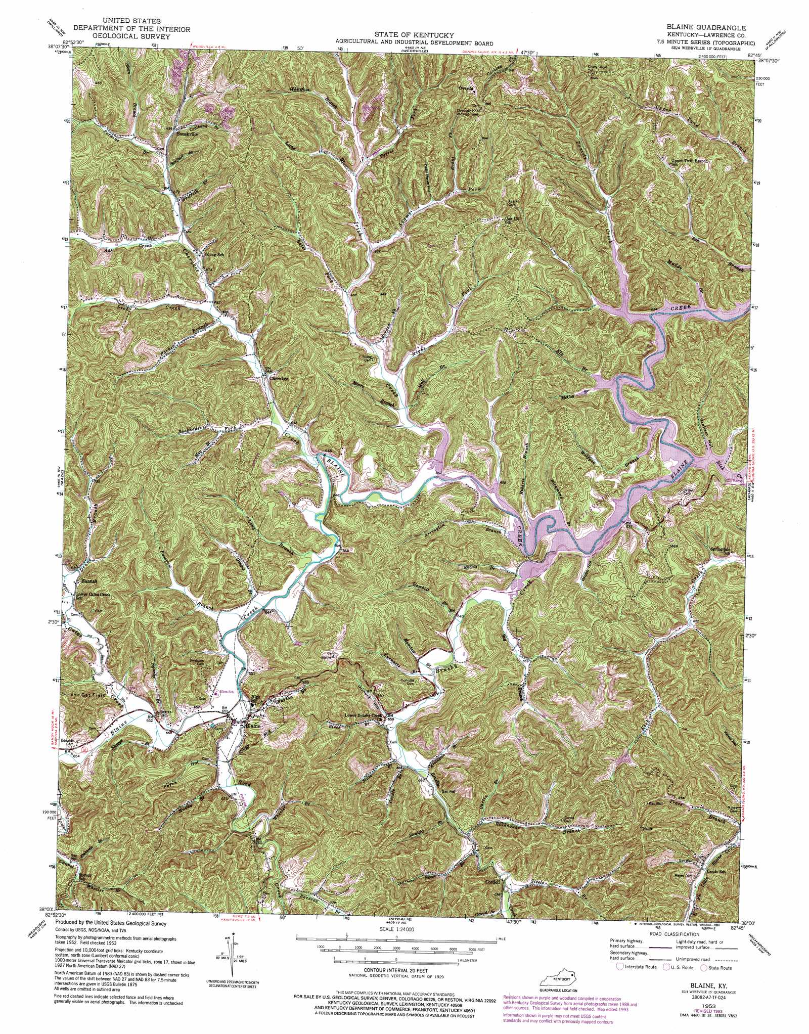
Blaine Topo Map Kentucky
To zoom in, hover over the map of Blaine
USGS Topo Quad 38082a7 - 1:24,000 scale
| Topo Map Name: | Blaine |
| USGS Topo Quad ID: | 38082a7 |
| Print Size: | ca. 21 1/4" wide x 27" high |
| Southeast Coordinates: | 38° N latitude / 82.75° W longitude |
| Map Center Coordinates: | 38.0625° N latitude / 82.8125° W longitude |
| U.S. State: | KY |
| Filename: | o38082a7.jpg |
| Download Map JPG Image: | Blaine topo map 1:24,000 scale |
| Map Type: | Topographic |
| Topo Series: | 7.5´ |
| Map Scale: | 1:24,000 |
| Source of Map Images: | United States Geological Survey (USGS) |
| Alternate Map Versions: |
Blaine KY 1953, updated 1955 Download PDF Buy paper map Blaine KY 1953, updated 1973 Download PDF Buy paper map Blaine KY 1953, updated 1978 Download PDF Buy paper map Blaine KY 1953, updated 1993 Download PDF Buy paper map Blaine KY 2010 Download PDF Buy paper map Blaine KY 2013 Download PDF Buy paper map Blaine KY 2016 Download PDF Buy paper map |
1:24,000 Topo Quads surrounding Blaine
Grahn |
Grayson |
Rush |
Boltsfork |
Burnaugh |
Bruin |
Willard |
Webbville |
Fallsburg |
Prichard |
Isonville |
Mazie |
Blaine |
Adams |
Louisa |
Dingus |
Redbush |
Sitka |
Richardson |
Milo |
Salyersville North |
Oil Springs |
Paintsville |
Offutt |
Inez |
> Back to 38082a1 at 1:100,000 scale
> Back to 38082a1 at 1:250,000 scale
> Back to U.S. Topo Maps home
Blaine topo map: Gazetteer
Blaine: Bends
The Narrows elevation 201m 659′Blaine: Bridges
Wellman Bridge (historical) elevation 190m 623′Blaine: Populated Places
Blaine elevation 201m 659′Cherokee elevation 205m 672′
Cordell elevation 207m 679′
Elm Grove (historical) elevation 193m 633′
Hannah elevation 208m 682′
Houckville elevation 244m 800′
Overda elevation 282m 925′
Prosperity (historical) elevation 198m 649′
Providence (historical) elevation 194m 636′
Blaine: Post Offices
Blaine Post Office (historical) elevation 201m 659′Cordell Post Office (historical) elevation 208m 682′
Hannah Post Office (historical) elevation 208m 682′
Mattie Post Office (historical) elevation 230m 754′
Overda Post Office (historical) elevation 303m 994′
Prosperity Post Office (historical) elevation 198m 649′
Waterson Post Office (historical) elevation 198m 649′
Blaine: Streams
Abb Creek elevation 200m 656′Adams Fork elevation 220m 721′
Arrington Branch elevation 190m 623′
Arrington Branch elevation 199m 652′
Bates Fork elevation 203m 666′
Big Branch elevation 192m 629′
Birch Branch elevation 198m 649′
Brushy Creek elevation 190m 623′
Buffalo Branch elevation 206m 675′
Burton Branch elevation 195m 639′
Cains Creek elevation 198m 649′
Cherokee Creek elevation 190m 623′
Coalbank Branch elevation 215m 705′
Cordle Branch elevation 200m 656′
Curnutte Branch elevation 194m 636′
Daniels Creek elevation 190m 623′
Deans Branch elevation 206m 675′
Dingus Branch elevation 196m 643′
Elk Branch elevation 190m 623′
Evans Branch elevation 190m 623′
Evans Fork elevation 226m 741′
Ferrel Fork elevation 207m 679′
Fishtrap Branch elevation 206m 675′
Gambill Branch elevation 192m 629′
Gartin Branch elevation 219m 718′
Gravel Branch elevation 209m 685′
Griffin Branch elevation 205m 672′
Hood Creek elevation 197m 646′
Irish Creek elevation 190m 623′
Jordan Fork elevation 194m 636′
Lane Branch elevation 208m 682′
Lick Branch elevation 190m 623′
Lick Creek elevation 198m 649′
Long Branch elevation 194m 636′
Long Fork elevation 232m 761′
May Branch elevation 205m 672′
McCoy Branch elevation 190m 623′
Meadow Branch elevation 194m 636′
Middle Daniels Creek elevation 190m 623′
Moore Branch elevation 193m 633′
Muddy Branch elevation 190m 623′
Muddy Branch elevation 197m 646′
Parker Branch elevation 198m 649′
Pawpaw Branch elevation 195m 639′
Perkins Branch elevation 213m 698′
Pleas Creek elevation 189m 620′
Raccoon Branch elevation 203m 666′
Rich Creek elevation 190m 623′
Richmond Branch elevation 190m 623′
Right Fork Irish Creek elevation 193m 633′
Road Fork of Daniels Creek elevation 195m 639′
Roberts Branch elevation 190m 623′
Rockhouse Branch elevation 201m 659′
Rockhouse Fork elevation 193m 633′
Sawmill Branch elevation 208m 682′
Skaggs Branch elevation 197m 646′
Slate Branch elevation 201m 659′
Sloan Branch elevation 212m 695′
Sparks Branch elevation 195m 639′
Steele Branch elevation 208m 682′
Straight Branch elevation 198m 649′
Swan Branch elevation 204m 669′
Swetnam Creek elevation 195m 639′
Wheeler Branch elevation 219m 718′
Wheeler Branch elevation 201m 659′
Whiteface Branch elevation 225m 738′
Wolf Branch elevation 194m 636′
Wolfpen Branch elevation 192m 629′
Blaine: Summits
Cherokee Hill elevation 237m 777′Blaine: Valleys
Dead Horse Hollow elevation 210m 688′Graham Hollow elevation 190m 623′
Grubb Hollow elevation 194m 636′
Orchard Hollow elevation 201m 659′
Payne Hollow elevation 203m 666′
Blaine digital topo map on disk
Buy this Blaine topo map showing relief, roads, GPS coordinates and other geographical features, as a high-resolution digital map file on DVD:
Western Virginia & Southern West Virginia
Buy digital topo maps: Western Virginia & Southern West Virginia