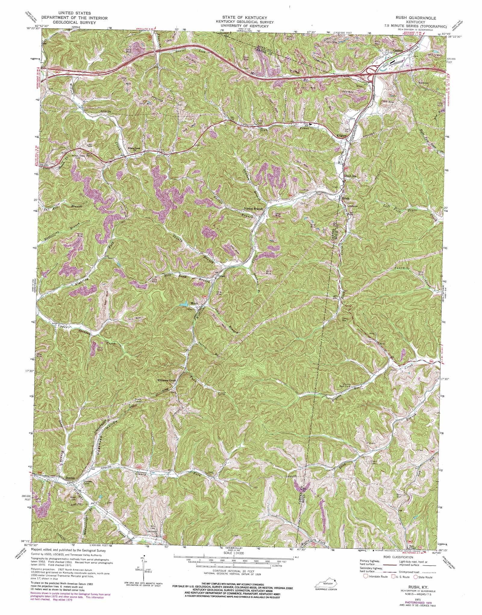
Rush Topo Map Kentucky
To zoom in, hover over the map of Rush
USGS Topo Quad 38082c7 - 1:24,000 scale
| Topo Map Name: | Rush |
| USGS Topo Quad ID: | 38082c7 |
| Print Size: | ca. 21 1/4" wide x 27" high |
| Southeast Coordinates: | 38.25° N latitude / 82.75° W longitude |
| Map Center Coordinates: | 38.3125° N latitude / 82.8125° W longitude |
| U.S. State: | KY |
| Filename: | o38082c7.jpg |
| Download Map JPG Image: | Rush topo map 1:24,000 scale |
| Map Type: | Topographic |
| Topo Series: | 7.5´ |
| Map Scale: | 1:24,000 |
| Source of Map Images: | United States Geological Survey (USGS) |
| Alternate Map Versions: |
Rush KY 1953, updated 1955 Download PDF Buy paper map Rush KY 1953, updated 1967 Download PDF Buy paper map Rush KY 1971, updated 1973 Download PDF Buy paper map Rush KY 1971, updated 1979 Download PDF Buy paper map Rush KY 2010 Download PDF Buy paper map Rush KY 2013 Download PDF Buy paper map Rush KY 2016 Download PDF Buy paper map |
1:24,000 Topo Quads surrounding Rush
Brushart |
Load |
Greenup |
Ironton |
Kitts Hill |
Tygarts Valley |
Oldtown |
Argillite |
Ashland |
Catlettsburg |
Grahn |
Grayson |
Rush |
Boltsfork |
Burnaugh |
Bruin |
Willard |
Webbville |
Fallsburg |
Prichard |
Isonville |
Mazie |
Blaine |
Adams |
Louisa |
> Back to 38082a1 at 1:100,000 scale
> Back to 38082a1 at 1:250,000 scale
> Back to U.S. Topo Maps home
Rush topo map: Gazetteer
Rush: Populated Places
Coalton elevation 187m 613′Denton elevation 193m 633′
Grant elevation 207m 679′
Music elevation 213m 698′
North Branch elevation 199m 652′
Rush elevation 194m 636′
Williams Creek elevation 236m 774′
Rush: Post Offices
Coalton Post Office (historical) elevation 198m 649′Music Post Office (historical) elevation 213m 698′
Norton Post Office (historical) elevation 201m 659′
Rush Post Office elevation 194m 636′
Seney Post Office (historical) elevation 198m 649′
Williams Creek Station (historical) elevation 237m 777′
Rush: Streams
Dawson Branch elevation 205m 672′Fighting Fork elevation 193m 633′
Glancy Fork elevation 192m 629′
Gravel Lick elevation 201m 659′
Hammertight Branch elevation 204m 669′
Lick Branch elevation 212m 695′
Mill Road Branch elevation 207m 679′
Norton Branch elevation 200m 656′
Rush Creek elevation 192m 629′
Shanty Branch elevation 210m 688′
Shop Branch elevation 192m 629′
Star Creek elevation 192m 629′
Suesie Branch elevation 222m 728′
Swanson Branch elevation 205m 672′
Twin Lick elevation 228m 748′
Rush: Summits
Star Hill elevation 257m 843′Rush: Tunnels
Means Tunnel elevation 279m 915′Rush: Valleys
Dinnens Branch elevation 211m 692′Foggy Hollow elevation 222m 728′
Hogshead Hollow elevation 191m 626′
Jacobs Hollow elevation 205m 672′
Rush digital topo map on disk
Buy this Rush topo map showing relief, roads, GPS coordinates and other geographical features, as a high-resolution digital map file on DVD:
Western Virginia & Southern West Virginia
Buy digital topo maps: Western Virginia & Southern West Virginia