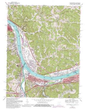
Catlettsburg Topo Map Ohio
To zoom in, hover over the map of Catlettsburg
USGS Topo Quad 38082d5 - 1:24,000 scale
| Topo Map Name: | Catlettsburg |
| USGS Topo Quad ID: | 38082d5 |
| Print Size: | ca. 21 1/4" wide x 27" high |
| Southeast Coordinates: | 38.375° N latitude / 82.5° W longitude |
| Map Center Coordinates: | 38.4375° N latitude / 82.5625° W longitude |
| U.S. States: | OH, WV, KY |
| Filename: | o38082d5.jpg |
| Download Map JPG Image: | Catlettsburg topo map 1:24,000 scale |
| Map Type: | Topographic |
| Topo Series: | 7.5´ |
| Map Scale: | 1:24,000 |
| Source of Map Images: | United States Geological Survey (USGS) |
| Alternate Map Versions: |
Catlettsburg KY 1953, updated 1955 Download PDF Buy paper map Catlettsburg KY 1957, updated 1958 Download PDF Buy paper map Catlettsburg KY 1957, updated 1965 Download PDF Buy paper map Catlettsburg KY 1968, updated 1970 Download PDF Buy paper map Catlettsburg KY 1968, updated 1976 Download PDF Buy paper map Catlettsburg KY 1968, updated 1985 Download PDF Buy paper map Catlettsburg KY 2011 Download PDF Buy paper map Catlettsburg KY 2013 Download PDF Buy paper map Catlettsburg KY 2016 Download PDF Buy paper map |
1:24,000 Topo Quads surrounding Catlettsburg
> Back to 38082a1 at 1:100,000 scale
> Back to 38082a1 at 1:250,000 scale
> Back to U.S. Topo Maps home
Catlettsburg topo map: Gazetteer
Catlettsburg: Capes
Virginia Point elevation 163m 534′Catlettsburg: Crossings
Interchange 1 elevation 189m 620′Catlettsburg: Dams
Bowers Lake Dam elevation 217m 711′Lock and Dam Number 28 (historical) elevation 157m 515′
Lock and Dam Number 29 (historical) elevation 156m 511′
National Steel-Ohio River Site Dam (historical) elevation 239m 784′
US Lock Number 29 elevation 158m 518′
Catlettsburg: Parks
Camden Amusement Park elevation 166m 544′Wall Park elevation 186m 610′
Catlettsburg: Pillars
Chimney Rock elevation 207m 679′Catlettsburg: Populated Places
Big Sandy Junction elevation 170m 557′Brayfield elevation 169m 554′
Brookdale elevation 170m 557′
Burlington elevation 170m 557′
Catlettsburg elevation 169m 554′
Ceredo elevation 168m 551′
Clearview elevation 170m 557′
Cliffside elevation 165m 541′
Essex elevation 189m 620′
Glenroy elevation 170m 557′
Grandview Gardens elevation 222m 728′
Howell elevation 171m 561′
Hyland elevation 169m 554′
Kenova elevation 170m 557′
Lincoln Park elevation 235m 770′
Lockdale elevation 169m 554′
Montreal (historical) elevation 196m 643′
Normal elevation 172m 564′
North Kenova elevation 171m 561′
Oakland Addition (historical) elevation 174m 570′
Oakview Heights elevation 203m 666′
Riggs Tract (historical) elevation 169m 554′
Sheridan elevation 165m 541′
South Point elevation 172m 564′
Spring Valley elevation 204m 669′
Sulphur Springs elevation 202m 662′
Sunrise elevation 256m 839′
Sybene elevation 173m 567′
Walnut Park elevation 171m 561′
Westmoreland elevation 165m 541′
Willowvale elevation 170m 557′
Catlettsburg: Post Offices
Burlington Post Office (historical) elevation 170m 557′Ceredo Post Office elevation 168m 551′
Essex Post Office (historical) elevation 189m 620′
Howell Post Office (historical) elevation 171m 561′
Kenova Post Office elevation 170m 557′
Montreal Post Office (historical) elevation 201m 659′
Sheridan Post Office (historical) elevation 164m 538′
South Point Post Office elevation 172m 564′
Sybene Post Office (historical) elevation 172m 564′
Catlettsburg: Reservoirs
Bowers Lake elevation 217m 711′Catlettsburg: Streams
Ankrims Run elevation 164m 538′Barbecue Branch elevation 159m 521′
Big Sandy River elevation 160m 524′
Catletts Creek elevation 161m 528′
Chadwick Creek elevation 160m 524′
Clyffeside Branch elevation 162m 531′
Fourpole Creek elevation 162m 531′
Haines Branch Buffalo Creek elevation 169m 554′
Haney Branch elevation 156m 511′
Horse Creek elevation 159m 521′
Ice Dam Creek elevation 160m 524′
Jordans Branch elevation 162m 531′
Keys Creek elevation 157m 515′
Krout Creek elevation 158m 518′
Lick Creek elevation 160m 524′
Middle Leatherwood Creek elevation 181m 593′
Miller Creek elevation 160m 524′
Paddle Creek elevation 162m 531′
Scarey Creek elevation 170m 557′
Solida Creek elevation 156m 511′
Twelvepole Creek elevation 157m 515′
Twin Fork elevation 177m 580′
Upper Chadwick Creek elevation 165m 541′
Willow Creek elevation 171m 561′
Catlettsburg: Summits
Cartrell Hill elevation 207m 679′Catlettsburg: Valleys
Derifield Hollow elevation 199m 652′Possum Hollow elevation 169m 554′
Catlettsburg digital topo map on disk
Buy this Catlettsburg topo map showing relief, roads, GPS coordinates and other geographical features, as a high-resolution digital map file on DVD:
Western Virginia & Southern West Virginia
Buy digital topo maps: Western Virginia & Southern West Virginia


