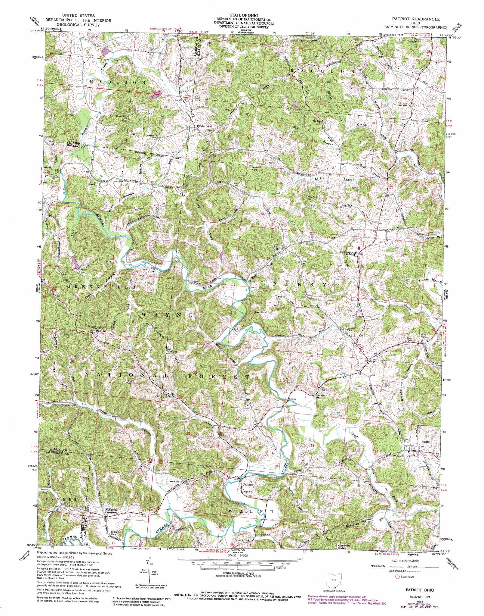
Patriot Topo Map Ohio
To zoom in, hover over the map of Patriot
USGS Topo Quad 38082g4 - 1:24,000 scale
| Topo Map Name: | Patriot |
| USGS Topo Quad ID: | 38082g4 |
| Print Size: | ca. 21 1/4" wide x 27" high |
| Southeast Coordinates: | 38.75° N latitude / 82.375° W longitude |
| Map Center Coordinates: | 38.8125° N latitude / 82.4375° W longitude |
| U.S. State: | OH |
| Filename: | o38082g4.jpg |
| Download Map JPG Image: | Patriot topo map 1:24,000 scale |
| Map Type: | Topographic |
| Topo Series: | 7.5´ |
| Map Scale: | 1:24,000 |
| Source of Map Images: | United States Geological Survey (USGS) |
| Alternate Map Versions: |
Patriot OH 1961, updated 1963 Download PDF Buy paper map Patriot OH 1961, updated 1984 Download PDF Buy paper map Patriot OH 1961, updated 1990 Download PDF Buy paper map Patriot OH 2002, updated 2006 Download PDF Buy paper map Patriot OH 2011 Download PDF Buy paper map Patriot OH 2013 Download PDF Buy paper map Patriot OH 2016 Download PDF Buy paper map |
| FStopo: | US Forest Service topo Patriot is available: Download FStopo PDF Download FStopo TIF |
1:24,000 Topo Quads surrounding Patriot
Jackson |
Wellston |
Mulga |
Wilkesville |
Rutland |
Petersburg |
Oak Hill |
Rio Grande |
Vinton |
Addison |
South Webster |
Gallia |
Patriot |
Rodney |
Gallipolis |
Pedro |
Sherritts |
Waterloo |
Mercerville |
Apple Grove |
Ironton |
Kitts Hill |
Aid |
Athalia |
Glenwood |
> Back to 38082e1 at 1:100,000 scale
> Back to 38082a1 at 1:250,000 scale
> Back to U.S. Topo Maps home
Patriot topo map: Gazetteer
Patriot: Bridges
Cadmus Covered Bridge elevation 189m 620′Patriot: Dams
Camp Francis Asbury Pond Dam elevation 213m 698′Donta Pond Dam elevation 202m 662′
Wayne National Forest Pond 8623-002 Dam elevation 207m 679′
Patriot: Populated Places
Cadmus elevation 189m 620′Centerpoint elevation 230m 754′
Gage elevation 202m 662′
McDaniel Crossroad elevation 194m 636′
Patriot elevation 221m 725′
Tynrhos (historical) elevation 243m 797′
Patriot: Post Offices
Cadmus Post Office (historical) elevation 188m 616′Gage Post Office (historical) elevation 204m 669′
Patriot Post Office elevation 219m 718′
Patriot: Reservoirs
Camp Francis Asbury Pond elevation 213m 698′Donta Pond elevation 202m 662′
Kenton Lake elevation 206m 675′
Wayne National Forest Pond 8623- elevation 207m 679′
Patriot: Streams
Big Beaver Creek elevation 177m 580′Black Fork elevation 194m 636′
Bull Run elevation 199m 652′
Camp Creek elevation 188m 616′
Carpenter Creek elevation 197m 646′
Coal Branch elevation 191m 626′
Granny Branch elevation 199m 652′
Lick Branch elevation 191m 626′
Little Beaver Creek elevation 178m 583′
Rocky Fork elevation 191m 626′
Roush Run elevation 188m 616′
Sand Fork elevation 189m 620′
Sweetbit Creek elevation 197m 646′
Trace Creek elevation 183m 600′
Wolf Run elevation 191m 626′
Patriot: Valleys
Burnette Hollow elevation 196m 643′Carpenter Hollow elevation 192m 629′
Hunt Hollow elevation 191m 626′
Patriot digital topo map on disk
Buy this Patriot topo map showing relief, roads, GPS coordinates and other geographical features, as a high-resolution digital map file on DVD:
Western Virginia & Southern West Virginia
Buy digital topo maps: Western Virginia & Southern West Virginia