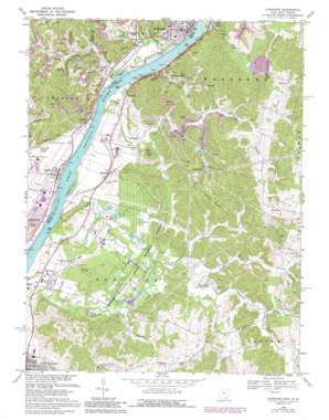
Cheshire Topo Map West Virginia
To zoom in, hover over the map of Cheshire
USGS Topo Quad 38082h1 - 1:24,000 scale
| Topo Map Name: | Cheshire |
| USGS Topo Quad ID: | 38082h1 |
| Print Size: | ca. 21 1/4" wide x 27" high |
| Southeast Coordinates: | 38.875° N latitude / 82° W longitude |
| Map Center Coordinates: | 38.9375° N latitude / 82.0625° W longitude |
| U.S. States: | WV, OH |
| Filename: | o38082h1.jpg |
| Download Map JPG Image: | Cheshire topo map 1:24,000 scale |
| Map Type: | Topographic |
| Topo Series: | 7.5´ |
| Map Scale: | 1:24,000 |
| Source of Map Images: | United States Geological Survey (USGS) |
| Alternate Map Versions: |
Cheshire OH 1958, updated 1959 Download PDF Buy paper map Cheshire OH 1968, updated 1970 Download PDF Buy paper map Cheshire OH 1968, updated 1976 Download PDF Buy paper map Cheshire OH 1968, updated 1986 Download PDF Buy paper map Cheshire OH 1968, updated 1989 Download PDF Buy paper map Cheshire OH 2011 Download PDF Buy paper map Cheshire OH 2013 Download PDF Buy paper map Cheshire OH 2016 Download PDF Buy paper map |
1:24,000 Topo Quads surrounding Cheshire
> Back to 38082e1 at 1:100,000 scale
> Back to 38082a1 at 1:250,000 scale
> Back to U.S. Topo Maps home
Cheshire topo map: Gazetteer
Cheshire: Airports
Jaymar Heliport elevation 172m 564′Mason County Airport elevation 193m 633′
Cheshire: Dams
Gavin Bottom Ash Pond Dam elevation 171m 561′McClintic Wildlife Pond Number 18 Dam elevation 216m 708′
McClintic Wildlife Pond Number Three Dam elevation 184m 603′
Cheshire: Islands
Eightmile Island elevation 168m 551′Cheshire: Lakes
Blue Goose Pond elevation 174m 570′Cheshire: Parks
Clifton F McClintic State Wildlife Station elevation 183m 600′McClintic Wildlife Management Area elevation 185m 606′
Cheshire: Populated Places
Carlton elevation 174m 570′Cheshire elevation 173m 567′
Fairview elevation 209m 685′
Hallwood elevation 177m 580′
Hobson elevation 173m 567′
Hobson Junction elevation 173m 567′
Lakin elevation 184m 603′
Maggie elevation 171m 561′
Oldtown (historical) elevation 186m 610′
Pike Hill elevation 235m 770′
Sassafras elevation 213m 698′
Silver Run elevation 172m 564′
West Columbia elevation 174m 570′
Cheshire: Post Offices
Carlton Post Office (historical) elevation 173m 567′Cheshire Post Office elevation 172m 564′
Muskingum Post Office (historical) elevation 233m 764′
Silver Run Post Office (historical) elevation 175m 574′
West Columbia Post Office elevation 174m 570′
Cheshire: Reservoirs
Gavin Bottom Ash Pond elevation 171m 561′Pond Number Nine elevation 174m 570′
Cheshire: Ridges
Mission Ridge elevation 263m 862′Cheshire: Springs
Howard Yeager Spring elevation 194m 636′Howard Yeager Spring elevation 241m 790′
Howard Yeager Spring elevation 221m 725′
Larry Sullivan Spring elevation 200m 656′
Leslie Rayburn Spring elevation 193m 633′
Logan Burdette Spring elevation 235m 770′
McCoy Spring elevation 180m 590′
Virgil Adkins Spring elevation 196m 643′
Cheshire: Streams
Ice Creek elevation 164m 538′Leading Creek elevation 164m 538′
Mill Run elevation 164m 538′
Potter Creek elevation 173m 567′
Rayburn Creek elevation 178m 583′
Robinson Run elevation 173m 567′
Silver Run elevation 172m 564′
Storys Run elevation 165m 541′
Tenmile Creek elevation 165m 541′
Thomas Fork elevation 169m 554′
Trace Fork elevation 184m 603′
Turkey Run elevation 170m 557′
Wolfpen Branch elevation 184m 603′
Cheshire digital topo map on disk
Buy this Cheshire topo map showing relief, roads, GPS coordinates and other geographical features, as a high-resolution digital map file on DVD:
Western Virginia & Southern West Virginia
Buy digital topo maps: Western Virginia & Southern West Virginia


