Rio Grande Topo Map Ohio
To zoom in, hover over the map of Rio Grande
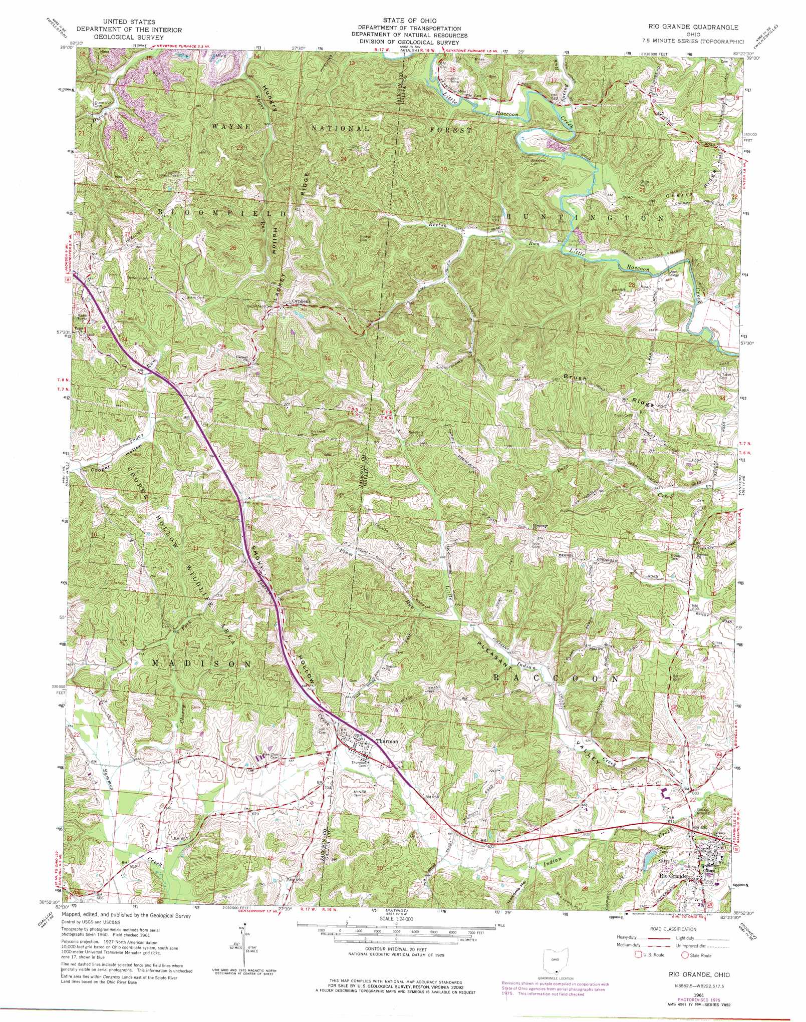
USGS Topo Quad 38082h4 - 1:24,000 scale
| Topo Map Name: | Rio Grande |
| USGS Topo Quad ID: | 38082h4 |
| Print Size: | ca. 21 1/4" wide x 27" high |
| Southeast Coordinates: | 38.875° N latitude / 82.375° W longitude |
| Map Center Coordinates: | 38.9375° N latitude / 82.4375° W longitude |
| U.S. State: | OH |
| Filename: | o38082h4.jpg |
| Download Map JPG Image: | Rio Grande topo map 1:24,000 scale |
| Map Type: | Topographic |
| Topo Series: | 7.5´ |
| Map Scale: | 1:24,000 |
| Source of Map Images: | United States Geological Survey (USGS) |
| Alternate Map Versions: |
Rio Grande OH 1961, updated 1963 Download PDF Buy paper map Rio Grande OH 1961, updated 1973 Download PDF Buy paper map Rio Grande OH 1961, updated 1977 Download PDF Buy paper map Rio Grande OH 2010 Download PDF Buy paper map Rio Grande OH 2013 Download PDF Buy paper map Rio Grande OH 2016 Download PDF Buy paper map |
1:24,000 Topo Quads surrounding Rio Grande
Byer |
Hamden |
Mcarthur |
Vales Mills |
Albany |
Jackson |
Wellston |
Mulga |
Wilkesville |
Rutland |
Petersburg |
Oak Hill |
Rio Grande |
Vinton |
Addison |
South Webster |
Gallia |
Patriot |
Rodney |
Gallipolis |
Pedro |
Sherritts |
Waterloo |
Mercerville |
Apple Grove |
> Back to 38082e1 at 1:100,000 scale
> Back to 38082a1 at 1:250,000 scale
> Back to U.S. Topo Maps home
Rio Grande topo map: Gazetteer
Rio Grande: Bridges
Calhoun Bridge elevation 183m 600′Ghee Bridge elevation 186m 610′
Rio Grande: Dams
Rio Grande Reservoir Dam elevation 205m 672′Rio Grande: Parks
Cooper Hollow Wildlife Area elevation 256m 839′Stanley L Evans Athletic and Recreation Field elevation 189m 620′
Rio Grande: Populated Places
Edna (historical) elevation 185m 606′Orpheus elevation 268m 879′
Rio Grande elevation 198m 649′
Thurman elevation 207m 679′
Vega elevation 275m 902′
Rio Grande: Post Offices
Edna Post Office (historical) elevation 183m 600′Orpheus Post Office (historical) elevation 269m 882′
Rio Grande Post Office elevation 199m 652′
Thurman Post Office elevation 207m 679′
Rio Grande: Reservoirs
Rio Grande Reservoir elevation 205m 672′Rio Grande: Ridges
Brush Ridge elevation 250m 820′Cherry Ridge elevation 223m 731′
Lackey Ridge elevation 272m 892′
Rio Grande: Streams
Cherry Fork elevation 197m 646′Keeton Run elevation 183m 600′
Little Indian Creek elevation 177m 580′
Plum Run elevation 197m 646′
Spring Run elevation 181m 593′
Rio Grande: Valleys
Holcomb Hollow elevation 190m 623′Hungry Hollow elevation 200m 656′
Pleasant Valley elevation 183m 600′
Smoky Hollow elevation 198m 649′
Rio Grande digital topo map on disk
Buy this Rio Grande topo map showing relief, roads, GPS coordinates and other geographical features, as a high-resolution digital map file on DVD:
Western Virginia & Southern West Virginia
Buy digital topo maps: Western Virginia & Southern West Virginia