Bangor Topo Map Kentucky
To zoom in, hover over the map of Bangor
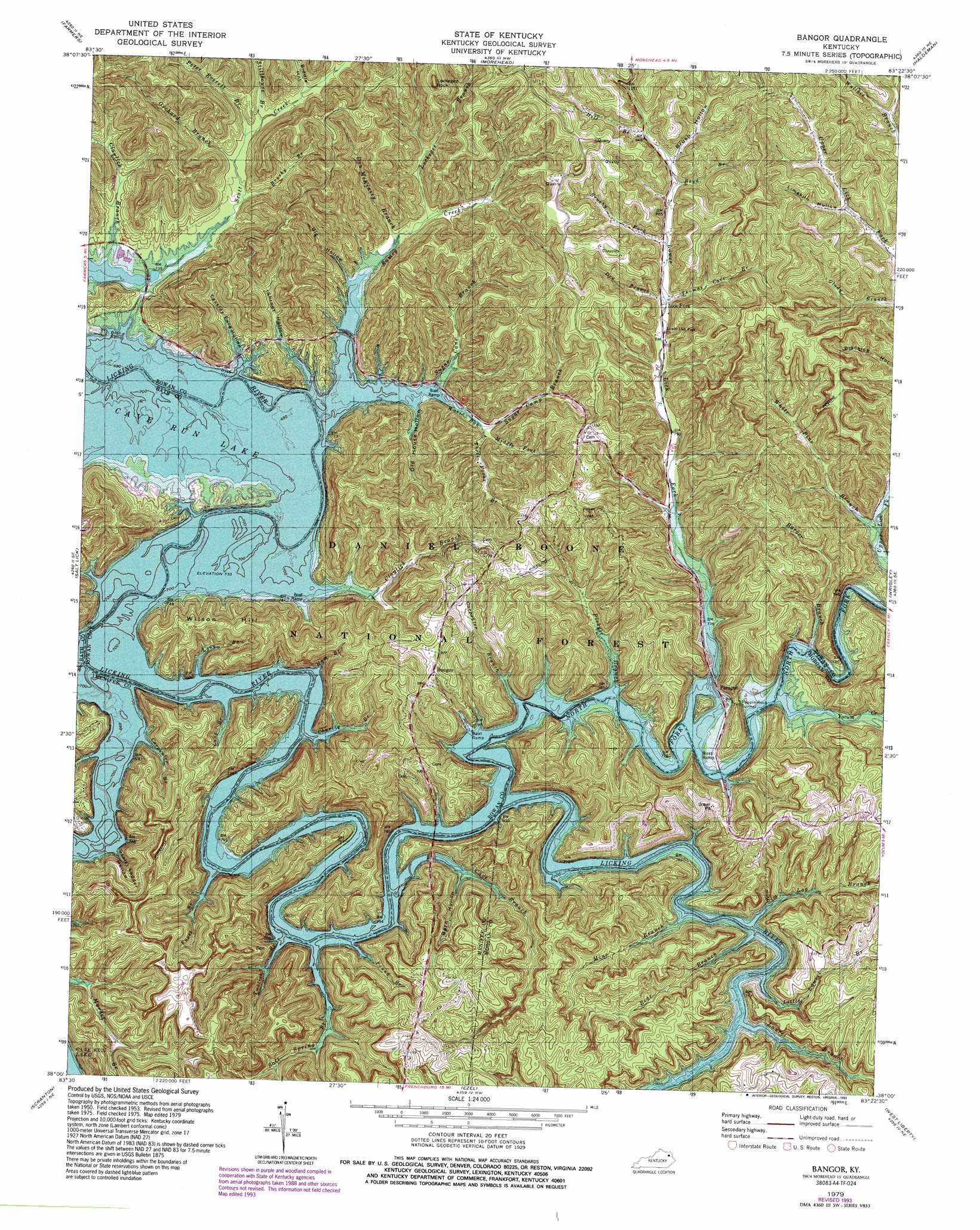
USGS Topo Quad 38083a4 - 1:24,000 scale
| Topo Map Name: | Bangor |
| USGS Topo Quad ID: | 38083a4 |
| Print Size: | ca. 21 1/4" wide x 27" high |
| Southeast Coordinates: | 38° N latitude / 83.375° W longitude |
| Map Center Coordinates: | 38.0625° N latitude / 83.4375° W longitude |
| U.S. State: | KY |
| Filename: | o38083a4.jpg |
| Download Map JPG Image: | Bangor topo map 1:24,000 scale |
| Map Type: | Topographic |
| Topo Series: | 7.5´ |
| Map Scale: | 1:24,000 |
| Source of Map Images: | United States Geological Survey (USGS) |
| Alternate Map Versions: |
Bangor KY 1953, updated 1954 Download PDF Buy paper map Bangor KY 1953, updated 1965 Download PDF Buy paper map Bangor KY 1979, updated 1979 Download PDF Buy paper map Bangor KY 1979, updated 1993 Download PDF Buy paper map Bangor KY 2011 Download PDF Buy paper map Bangor KY 2013 Download PDF Buy paper map Bangor KY 2016 Download PDF Buy paper map |
| FStopo: | US Forest Service topo Bangor is available: Download FStopo PDF Download FStopo TIF |
1:24,000 Topo Quads surrounding Bangor
Hillsboro |
Plummers Landing |
Cranston |
Soldier |
Olive Hill |
Colfax |
Farmers |
Morehead |
Haldeman |
Ault |
Olympia |
Salt Lick |
Bangor |
Wrigley |
Sandy Hook |
Frenchburg |
Scranton |
Ezel |
West Liberty |
Lenox |
Slade |
Pomeroyton |
Hazel Green |
Cannel City |
White Oak |
> Back to 38083a1 at 1:100,000 scale
> Back to 38082a1 at 1:250,000 scale
> Back to U.S. Topo Maps home
Bangor topo map: Gazetteer
Bangor: Lakes
Giant Canada Goose Pond elevation 232m 761′Bangor: Populated Places
Bangor elevation 220m 721′Cogswell elevation 241m 790′
Hickory Grove elevation 283m 928′
Lick Fork elevation 258m 846′
Mount Hope elevation 292m 958′
Paragon elevation 220m 721′
Zilpo Recreation Area elevation 226m 741′
Bangor: Post Offices
Bangor Post Office (historical) elevation 222m 728′Bertis Post Office (historical) elevation 220m 721′
Popping Post Office (historical) elevation 220m 721′
Wellford Post Office (historical) elevation 310m 1017′
Yale Post Office (historical) elevation 220m 721′
Zilpo Post Office (historical) elevation 235m 770′
Bangor: Streams
Barber Branch elevation 220m 721′Bear Branch elevation 220m 721′
Beaver Creek elevation 220m 721′
Boyd Branch elevation 273m 895′
Brushy Branch elevation 242m 793′
Brushy Fork elevation 262m 859′
Buck Creek elevation 220m 721′
Carpenter Branch elevation 220m 721′
Carpenter Branch elevation 220m 721′
Cave Branch elevation 220m 721′
Charity Branch elevation 220m 721′
Claylick Branch elevation 220m 721′
Claylick Branch elevation 220m 721′
Don McKinsey Branch elevation 231m 757′
Dry Branch elevation 253m 830′
Elm Log Branch elevation 220m 721′
Fuget Branch elevation 220m 721′
Ham Branch elevation 220m 721′
Hill Branch elevation 277m 908′
Laurel Branch elevation 220m 721′
Little Laurel Branch elevation 220m 721′
Lockegee Branch elevation 237m 777′
Long Branch elevation 220m 721′
Long Branch elevation 220m 721′
Lower Lick Fork elevation 220m 721′
Middle Fork elevation 237m 777′
Mine Branch elevation 220m 721′
North Fork Licking River elevation 220m 721′
Orchard Branch elevation 238m 780′
Peter Everett Branch elevation 241m 790′
Pickett Branch elevation 220m 721′
Pound Branch elevation 220m 721′
Ramey Creek elevation 220m 721′
Salt Spring Branch elevation 220m 721′
Stillhouse Branch elevation 244m 800′
Sugar Camp Branch elevation 234m 767′
Sugar Cane Branch elevation 220m 721′
Thomas Cave Branch elevation 251m 823′
Three Forks Branch elevation 234m 767′
Twolick Branch elevation 220m 721′
Warix Run elevation 220m 721′
White Pine Branch elevation 225m 738′
Yocum Creek elevation 220m 721′
Bangor: Summits
Lockegee Rock elevation 388m 1272′Poppin Hill elevation 289m 948′
Wilson Hill elevation 322m 1056′
Bangor: Tunnels
Poppin Rock Tunnel elevation 258m 846′Bangor: Valleys
Barn Hollow elevation 228m 748′Biddle Hollow elevation 255m 836′
Big Hollow elevation 222m 728′
Big Hollow elevation 224m 734′
Brush Hollow elevation 277m 908′
Cassidy Ford Hollow elevation 220m 721′
Limekiln Hollow elevation 274m 898′
Old House Hollow elevation 220m 721′
Scale Ladder Hollow elevation 220m 721′
Shrout Hollow elevation 220m 721′
Bangor digital topo map on disk
Buy this Bangor topo map showing relief, roads, GPS coordinates and other geographical features, as a high-resolution digital map file on DVD:
Western Virginia & Southern West Virginia
Buy digital topo maps: Western Virginia & Southern West Virginia