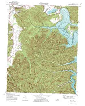
Salt Lick Topo Map Kentucky
To zoom in, hover over the map of Salt Lick
USGS Topo Quad 38083a5 - 1:24,000 scale
| Topo Map Name: | Salt Lick |
| USGS Topo Quad ID: | 38083a5 |
| Print Size: | ca. 21 1/4" wide x 27" high |
| Southeast Coordinates: | 38° N latitude / 83.5° W longitude |
| Map Center Coordinates: | 38.0625° N latitude / 83.5625° W longitude |
| U.S. State: | KY |
| Filename: | o38083a5.jpg |
| Download Map JPG Image: | Salt Lick topo map 1:24,000 scale |
| Map Type: | Topographic |
| Topo Series: | 7.5´ |
| Map Scale: | 1:24,000 |
| Source of Map Images: | United States Geological Survey (USGS) |
| Alternate Map Versions: |
Salt Lick KY 1953, updated 1954 Download PDF Buy paper map Salt Lick KY 1953, updated 1966 Download PDF Buy paper map Salt Lick KY 1975, updated 1977 Download PDF Buy paper map Salt Lick KY 2011 Download PDF Buy paper map Salt Lick KY 2013 Download PDF Buy paper map Salt Lick KY 2016 Download PDF Buy paper map |
| FStopo: | US Forest Service topo Salt Lick is available: Download FStopo PDF Download FStopo TIF |
1:24,000 Topo Quads surrounding Salt Lick
> Back to 38083a1 at 1:100,000 scale
> Back to 38082a1 at 1:250,000 scale
> Back to U.S. Topo Maps home
Salt Lick topo map: Gazetteer
Salt Lick: Cliffs
Cedar Cliffs elevation 345m 1131′Chestnut Cliffs elevation 370m 1213′
Salt Lick: Parks
Pioneer Weapons Hunting Area elevation 343m 1125′Salt Lick: Populated Places
Clear Creek Furnace elevation 232m 761′Leatherwood (historical) elevation 221m 725′
Lower Salt Lick elevation 208m 682′
Salt Lick elevation 206m 675′
White Sulpher elevation 223m 731′
Salt Lick: Post Offices
Cave Run Post Office (historical) elevation 220m 721′Costigan Post Office (historical) elevation 220m 721′
Licking Post Office (historical) elevation 201m 659′
Salt Lick Post Office elevation 206m 675′
Wickliffe Forge Post Office (historical) elevation 220m 721′
Yale Post Office (historical) elevation 220m 721′
Young Post Office (historical) elevation 219m 718′
Young Springs Post Office (historical) elevation 243m 797′
Salt Lick: Reservoirs
Cave Run Lake elevation 238m 780′Clear Creek Lake elevation 219m 718′
Salt Lick: Springs
Young Springs elevation 241m 790′Salt Lick: Streams
Big Cave Run elevation 225m 738′Billy Branch elevation 226m 741′
Boardinghouse Branch elevation 262m 859′
Caney Creek elevation 220m 721′
Cape Branch elevation 253m 830′
Carey Branch elevation 201m 659′
Clear Creek elevation 207m 679′
Glady Branch elevation 260m 853′
Graveyard Branch elevation 220m 721′
Green Branch elevation 206m 675′
Joes Branch elevation 242m 793′
Leatherwood Creek elevation 220m 721′
Little Cave Run elevation 222m 728′
Martins Branch elevation 205m 672′
McDale Branch elevation 213m 698′
McIntosh Branch elevation 225m 738′
Merry Branch elevation 210m 688′
Murder Branch elevation 226m 741′
Pendleton Branch elevation 214m 702′
Pergram Branch elevation 241m 790′
Peter Cave Run elevation 230m 754′
Reynolds Hollow elevation 229m 751′
Salt Lick Creek elevation 198m 649′
Scott Creek elevation 220m 721′
Skidmore Creek elevation 220m 721′
Stone Quarry Branch elevation 223m 731′
Sulphur Branch elevation 220m 721′
Trough Lick Branch elevation 223m 731′
White Sulphur Branch elevation 213m 698′
Salt Lick: Summits
Alum Knob elevation 247m 810′Buck Creek Hill elevation 362m 1187′
Gate Post Hill elevation 396m 1299′
Gate Post Hill elevation 410m 1345′
Leatherwood Hill elevation 369m 1210′
Tater Knob elevation 423m 1387′
Twin Knobs elevation 334m 1095′
Salt Lick: Trails
Buck Branch Trail elevation 256m 839′Buck Creek Trail elevation 242m 793′
Buckskin Trail elevation 250m 820′
Carrington Rock Trail elevation 350m 1148′
Cave Run Trail elevation 338m 1108′
Cedar Cliffs Trail elevation 366m 1200′
Cross Over Trail elevation 358m 1174′
Hog Pen Trail elevation 357m 1171′
Shallow Flats Wildlife Trail elevation 233m 764′
Sheltowee Trace elevation 233m 764′
Salt Lick: Valleys
Campbell Hollow elevation 206m 675′Dark Cave Hollow elevation 267m 875′
Dickerson Hollow elevation 207m 679′
Fletchum Hollow elevation 244m 800′
Glady Hollow elevation 266m 872′
Grubbs Hollow elevation 239m 784′
Hickory Hollow elevation 220m 721′
Hicks Hollow elevation 211m 692′
Hog Hollow elevation 208m 682′
Knob Hollow elevation 251m 823′
Reynolds Hollow elevation 224m 734′
Tram Road Hollow elevation 252m 826′
Wolfpen Hollow elevation 226m 741′
Salt Lick digital topo map on disk
Buy this Salt Lick topo map showing relief, roads, GPS coordinates and other geographical features, as a high-resolution digital map file on DVD:
Western Virginia & Southern West Virginia
Buy digital topo maps: Western Virginia & Southern West Virginia


