Cowan Topo Map Kentucky
To zoom in, hover over the map of Cowan
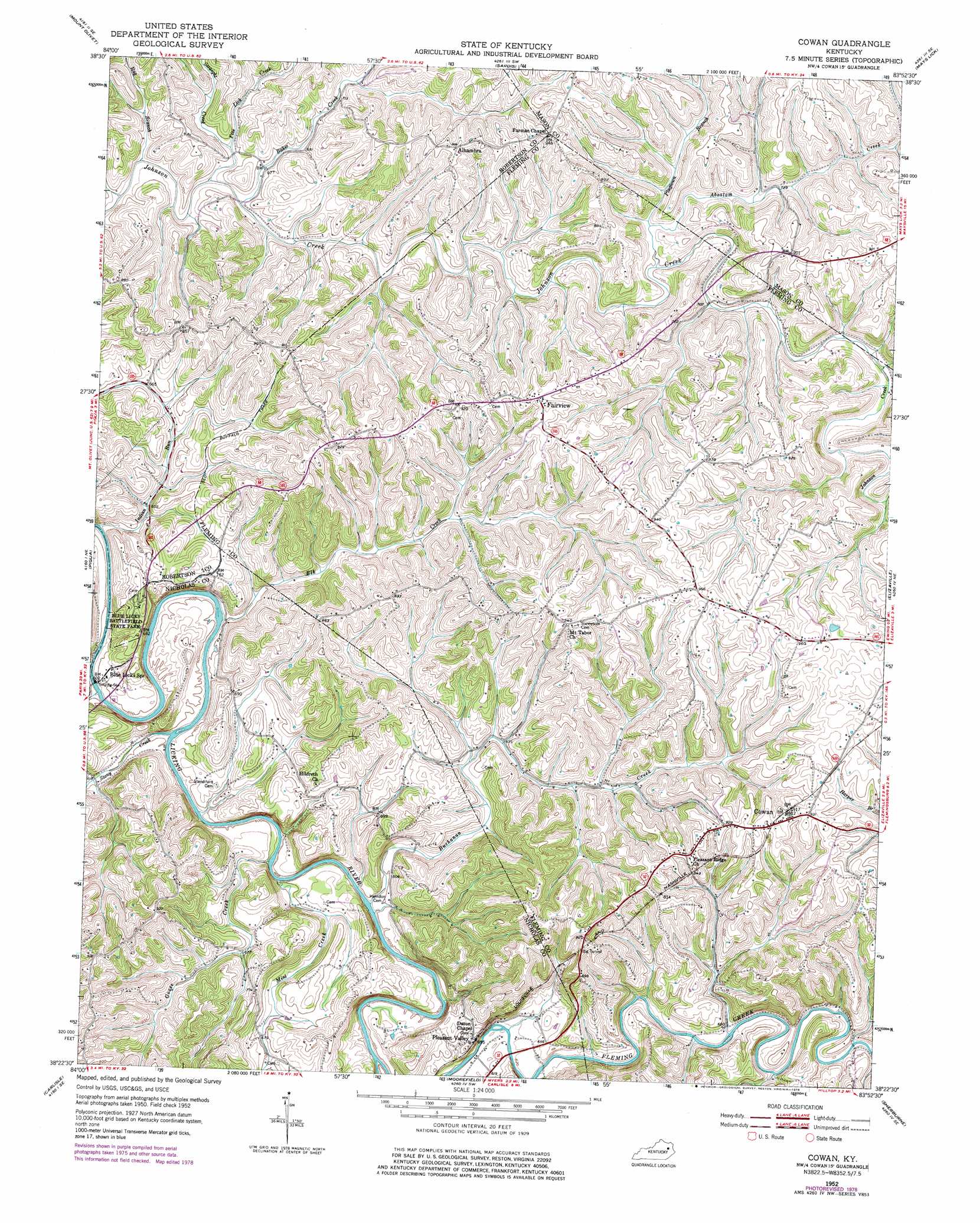
USGS Topo Quad 38083d8 - 1:24,000 scale
| Topo Map Name: | Cowan |
| USGS Topo Quad ID: | 38083d8 |
| Print Size: | ca. 21 1/4" wide x 27" high |
| Southeast Coordinates: | 38.375° N latitude / 83.875° W longitude |
| Map Center Coordinates: | 38.4375° N latitude / 83.9375° W longitude |
| U.S. State: | KY |
| Filename: | o38083d8.jpg |
| Download Map JPG Image: | Cowan topo map 1:24,000 scale |
| Map Type: | Topographic |
| Topo Series: | 7.5´ |
| Map Scale: | 1:24,000 |
| Source of Map Images: | United States Geological Survey (USGS) |
| Alternate Map Versions: |
Cowan KY 1952, updated 1953 Download PDF Buy paper map Cowan KY 1952, updated 1975 Download PDF Buy paper map Cowan KY 1952, updated 1978 Download PDF Buy paper map Cowan KY 2010 Download PDF Buy paper map Cowan KY 2013 Download PDF Buy paper map Cowan KY 2016 Download PDF Buy paper map |
1:24,000 Topo Quads surrounding Cowan
Berlin |
Brooksville |
Germantown |
Maysville West |
Maysville East |
Claysville |
Mount Olivet |
Sardis |
Mays Lick |
Orangeburg |
Shady Nook |
Piqua |
Cowan |
Elizaville |
Flemingsburg |
Millersburg |
Carlisle |
Moorefield |
Sherburne |
Hillsboro |
Paris East |
North Middletown |
Sharpsburg |
Owingsville |
Colfax |
> Back to 38083a1 at 1:100,000 scale
> Back to 38082a1 at 1:250,000 scale
> Back to U.S. Topo Maps home
Cowan topo map: Gazetteer
Cowan: Bends
The Bend of Licking elevation 183m 600′Cowan: Bridges
Johnson Bridge elevation 210m 688′Johnson Creek Covered Bridge (historical) elevation 199m 652′
Cowan: Parks
Blue Licks Battlefield State Park elevation 196m 643′Cowan: Populated Places
Alhambra elevation 276m 905′Cowan elevation 280m 918′
Fairview elevation 283m 928′
Pleasant Valley elevation 219m 718′
Cowan: Post Offices
Abner Post Office (historical) elevation 180m 590′Alhambra Post Office (historical) elevation 276m 905′
Burika Post Office (historical) elevation 258m 846′
Cowan Post Office (historical) elevation 281m 921′
Flora Post Office (historical) elevation 235m 770′
Licking Post Office (historical) elevation 213m 698′
Oakwood Post Office (historical) elevation 283m 928′
Pleasant Valley Post Office (historical) elevation 220m 721′
Cowan: Streams
Absalom Creek elevation 215m 705′Baker Creek elevation 201m 659′
Buchanan Creek elevation 175m 574′
Elk Creek elevation 175m 574′
Five Lick Creek elevation 199m 652′
Goose Creek elevation 175m 574′
Hoovers Run elevation 205m 672′
Indian Run elevation 175m 574′
Mint Creek elevation 179m 587′
Plugtown Branch elevation 219m 718′
Rag Branch elevation 203m 666′
Stony Creek elevation 175m 574′
Straight Creek elevation 205m 672′
Tabor Branch elevation 203m 666′
Tea Run elevation 193m 633′
Cowan: Summits
Cedar Hill elevation 220m 721′Tunnel Hill elevation 281m 921′
Cowan: Tunnels
Big Tunnel elevation 288m 944′Cowan digital topo map on disk
Buy this Cowan topo map showing relief, roads, GPS coordinates and other geographical features, as a high-resolution digital map file on DVD:
Western Virginia & Southern West Virginia
Buy digital topo maps: Western Virginia & Southern West Virginia