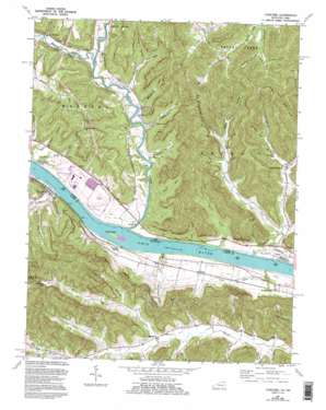
Concord Topo Map Ohio
To zoom in, hover over the map of Concord
USGS Topo Quad 38083f4 - 1:24,000 scale
| Topo Map Name: | Concord |
| USGS Topo Quad ID: | 38083f4 |
| Print Size: | ca. 21 1/4" wide x 27" high |
| Southeast Coordinates: | 38.625° N latitude / 83.375° W longitude |
| Map Center Coordinates: | 38.6875° N latitude / 83.4375° W longitude |
| U.S. States: | OH, KY |
| Filename: | o38083f4.jpg |
| Download Map JPG Image: | Concord topo map 1:24,000 scale |
| Map Type: | Topographic |
| Topo Series: | 7.5´ |
| Map Scale: | 1:24,000 |
| Source of Map Images: | United States Geological Survey (USGS) |
| Alternate Map Versions: |
Concord KY 1949, updated 1965 Download PDF Buy paper map Concord KY 1951 Download PDF Buy paper map Concord KY 1951 Download PDF Buy paper map Concord KY 1967, updated 1969 Download PDF Buy paper map Concord KY 1967, updated 1982 Download PDF Buy paper map Concord KY 1967, updated 1995 Download PDF Buy paper map Concord KY 2010 Download PDF Buy paper map Concord KY 2013 Download PDF Buy paper map Concord KY 2016 Download PDF Buy paper map |
1:24,000 Topo Quads surrounding Concord
> Back to 38083e1 at 1:100,000 scale
> Back to 38082a1 at 1:250,000 scale
> Back to U.S. Topo Maps home
Concord topo map: Gazetteer
Concord: Bars
Pennyweight Bar elevation 152m 498′Concord: Islands
Brush Creek Island elevation 152m 498′Concord: Parks
Abner Hollow Cincinnati Museum of Natural History Nature Preserve elevation 216m 708′Cincinnati Museum of Natural History Nature Preserve elevation 159m 521′
Cincinnati Museum of Natural History Nature Preserve elevation 188m 616′
Red Rock Cincinnati Museum of Natural History Nature Preserve elevation 271m 889′
Concord: Populated Places
Carrs elevation 164m 538′Concord elevation 165m 541′
Gemmer elevation 195m 639′
Grimes (historical) elevation 155m 508′
Queens elevation 171m 561′
Squirrel Town elevation 170m 557′
Stout elevation 158m 518′
Tulip elevation 253m 830′
Waggoner Ripple (historical) elevation 158m 518′
Concord: Post Offices
Carrs Post Office (historical) elevation 159m 521′Concord Post Office (historical) elevation 163m 534′
Grimes Post Office (historical) elevation 155m 508′
Jacktown Post Office (historical) elevation 202m 662′
Martins Fork Post Office (historical) elevation 170m 557′
Pugh Post Office (historical) elevation 166m 544′
Station Landing Post Office (historical) elevation 152m 498′
Stout Post Office elevation 158m 518′
Stouts Landing Post Office (historical) elevation 152m 498′
Tulip Post Office (historical) elevation 253m 830′
Waggoner Ripple Post Office (historical) elevation 158m 518′
Concord: Reservoirs
Mitchell Lake elevation 238m 780′Concord: Ridges
Cherry Ridge elevation 370m 1213′Concord: Streams
Alex Run elevation 151m 495′Asher Run elevation 151m 495′
Beasley Fork elevation 152m 498′
Blacks Run elevation 152m 498′
Cattail Run elevation 152m 498′
Cummings Creek elevation 151m 495′
Cummins Branch elevation 155m 508′
Greenhow Branch elevation 177m 580′
Lower Sister Creek elevation 151m 495′
Mackenzie Run elevation 153m 501′
Martin Fork elevation 171m 561′
Ohio Brush Creek elevation 152m 498′
Pond Run elevation 151m 495′
Pool Branch elevation 208m 682′
Puntenney Run elevation 168m 551′
Russell Fork Stout Creek elevation 155m 508′
Sexton Branch elevation 164m 538′
Smoky Creek elevation 151m 495′
Spring Run elevation 151m 495′
Stout Run elevation 152m 498′
Stricklet Branch elevation 182m 597′
Sycamore Creek elevation 151m 495′
Tracey Run elevation 157m 515′
Upper Sister Creek elevation 152m 498′
Waggoner Run elevation 153m 501′
Concord: Valleys
Blue Hollow elevation 158m 518′Brackman Hollow elevation 166m 544′
Cave Hollow elevation 174m 570′
Fairmont Hollow elevation 163m 534′
George Bruce Hollow elevation 180m 590′
Green Hollow elevation 187m 613′
Hut Hollow elevation 179m 587′
Lige Grimm Hollow elevation 174m 570′
McKee Hollow elevation 150m 492′
Mefford Hollow elevation 181m 593′
Morrison Hollow elevation 237m 777′
Oil Hollow elevation 202m 662′
Thompson Hollow elevation 193m 633′
Truitt Hollow elevation 242m 793′
Wolf Hollow elevation 165m 541′
Concord digital topo map on disk
Buy this Concord topo map showing relief, roads, GPS coordinates and other geographical features, as a high-resolution digital map file on DVD:
Western Virginia & Southern West Virginia
Buy digital topo maps: Western Virginia & Southern West Virginia


