Blue Creek Topo Map Ohio
To zoom in, hover over the map of Blue Creek
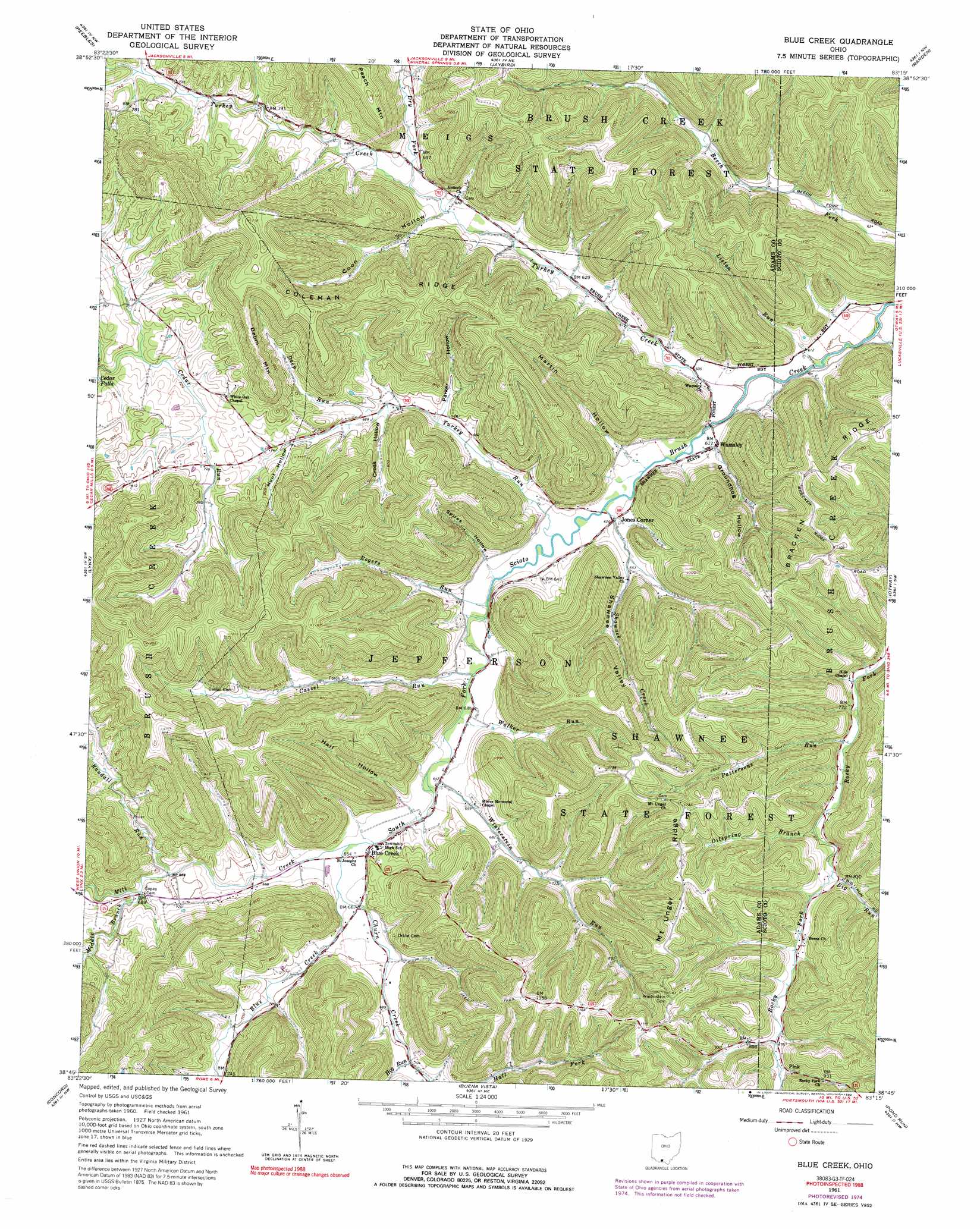
USGS Topo Quad 38083g3 - 1:24,000 scale
| Topo Map Name: | Blue Creek |
| USGS Topo Quad ID: | 38083g3 |
| Print Size: | ca. 21 1/4" wide x 27" high |
| Southeast Coordinates: | 38.75° N latitude / 83.25° W longitude |
| Map Center Coordinates: | 38.8125° N latitude / 83.3125° W longitude |
| U.S. State: | OH |
| Filename: | o38083g3.jpg |
| Download Map JPG Image: | Blue Creek topo map 1:24,000 scale |
| Map Type: | Topographic |
| Topo Series: | 7.5´ |
| Map Scale: | 1:24,000 |
| Source of Map Images: | United States Geological Survey (USGS) |
| Alternate Map Versions: |
Blue Creek OH 1961, updated 1962 Download PDF Buy paper map Blue Creek OH 1961, updated 1976 Download PDF Buy paper map Blue Creek OH 1961, updated 1992 Download PDF Buy paper map Blue Creek OH 2010 Download PDF Buy paper map Blue Creek OH 2013 Download PDF Buy paper map Blue Creek OH 2016 Download PDF Buy paper map |
1:24,000 Topo Quads surrounding Blue Creek
Belfast |
Sinking Spring |
Byington |
Latham |
Piketon |
Seaman |
Peebles |
Jaybird |
Rarden |
Wakefield |
West Union |
Lynx |
Blue Creek |
Otway |
West Portsmouth |
Manchester Islands |
Concord |
Buena Vista |
Pond Run |
Friendship |
Tollesboro |
Charters |
Vanceburg |
Garrison |
Brushart |
> Back to 38083e1 at 1:100,000 scale
> Back to 38082a1 at 1:250,000 scale
> Back to U.S. Topo Maps home
Blue Creek topo map: Gazetteer
Blue Creek: Populated Places
Blue Creek elevation 208m 682′Jones Corner elevation 188m 616′
Pink elevation 271m 889′
Wamsley elevation 191m 626′
Blue Creek: Post Offices
Blue Creek Post Office elevation 194m 636′Blue Creek Post Office (historical) elevation 208m 682′
Blue Creek: Ridges
Coleman Ridge elevation 344m 1128′Mount Unger Ridge elevation 343m 1125′
Blue Creek: Streams
Big Run elevation 248m 813′Big Run elevation 249m 816′
Blue Creek elevation 199m 652′
Cassel Run elevation 186m 610′
Cassel Run elevation 188m 616′
Churn Creek elevation 195m 639′
Deep Run elevation 206m 675′
Dry Fork elevation 201m 659′
Hog Run elevation 211m 692′
Laurel Run elevation 188m 616′
Liston Run elevation 183m 600′
Middle Branch elevation 207m 679′
Middle Branch Mill Creek elevation 207m 679′
Mill Creek elevation 195m 639′
Oilspring Branch elevation 238m 780′
Pattersons Run elevation 236m 774′
Randall Run elevation 203m 666′
Rogers Run elevation 191m 626′
Shawnee Creek elevation 184m 603′
Turkey Creek elevation 183m 600′
Turkey Run elevation 181m 593′
Walker Run elevation 186m 610′
Winterstein Run elevation 194m 636′
Blue Creek: Summits
Behm Mountain elevation 305m 1000′Blue Creek: Valleys
Coon Hollow elevation 201m 659′Cross Hollow elevation 218m 715′
Groundhog Hollow elevation 189m 620′
Hall Hollow elevation 202m 662′
Hunt Hollow elevation 217m 711′
Martin Hollow elevation 192m 629′
Rogers Hollow elevation 192m 629′
Shawnee Valley elevation 194m 636′
Spires Hollow elevation 189m 620′
Blue Creek digital topo map on disk
Buy this Blue Creek topo map showing relief, roads, GPS coordinates and other geographical features, as a high-resolution digital map file on DVD:
Western Virginia & Southern West Virginia
Buy digital topo maps: Western Virginia & Southern West Virginia