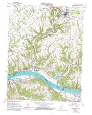
Higginsport Topo Map Ohio
To zoom in, hover over the map of Higginsport
USGS Topo Quad 38083g8 - 1:24,000 scale
| Topo Map Name: | Higginsport |
| USGS Topo Quad ID: | 38083g8 |
| Print Size: | ca. 21 1/4" wide x 27" high |
| Southeast Coordinates: | 38.75° N latitude / 83.875° W longitude |
| Map Center Coordinates: | 38.8125° N latitude / 83.9375° W longitude |
| U.S. States: | OH, KY |
| Filename: | o38083g8.jpg |
| Download Map JPG Image: | Higginsport topo map 1:24,000 scale |
| Map Type: | Topographic |
| Topo Series: | 7.5´ |
| Map Scale: | 1:24,000 |
| Source of Map Images: | United States Geological Survey (USGS) |
| Alternate Map Versions: |
Higginsport OH 1952, updated 1953 Download PDF Buy paper map Higginsport OH 1961, updated 1963 Download PDF Buy paper map Higginsport OH 1961, updated 1976 Download PDF Buy paper map Higginsport OH 1961, updated 1990 Download PDF Buy paper map Higginsport OH 2010 Download PDF Buy paper map Higginsport OH 2013 Download PDF Buy paper map Higginsport OH 2016 Download PDF Buy paper map |
1:24,000 Topo Quads surrounding Higginsport
> Back to 38083e1 at 1:100,000 scale
> Back to 38082a1 at 1:250,000 scale
> Back to U.S. Topo Maps home
Higginsport topo map: Gazetteer
Higginsport: Bars
Straight Creek Bar elevation 148m 485′Higginsport: Capes
Stony Point elevation 241m 790′Higginsport: Dams
Georgetown Upground Reservoir Dam elevation 200m 656′Higginsport: Parks
Georgetown Historic District elevation 281m 921′Higginsport: Populated Places
Centerpoint elevation 155m 508′Dover elevation 158m 518′
Eastland Mobile Home Park elevation 280m 918′
Georgetown elevation 280m 918′
Hammond Mobile Home Park elevation 279m 915′
Higginsport elevation 156m 511′
Levanna elevation 155m 508′
Reeds elevation 156m 511′
South Higginsport elevation 152m 498′
Stoney Point elevation 169m 554′
Higginsport: Post Offices
Georgetown Post Office elevation 280m 918′Higginsport Post Office elevation 156m 511′
Yellow Springs Post Office elevation 255m 836′
Higginsport: Reservoirs
Georgetown Upground Reservoir elevation 200m 656′Higginsport: Ridges
Cahall Ridge elevation 244m 800′Free Soil Ridge elevation 270m 885′
Lyon Ridge elevation 258m 846′
Shinkles Ridge elevation 274m 898′
Wood Ridge elevation 273m 895′
Higginsport: Streams
Bee Run elevation 156m 511′Big Run elevation 146m 479′
Boat Run elevation 152m 498′
Bracken Creek elevation 147m 482′
Cochran Run elevation 164m 538′
Donalds Creek elevation 150m 492′
Evans Run elevation 170m 557′
Hog Run elevation 152m 498′
Indian Creek elevation 147m 482′
Levanna Branch elevation 152m 498′
Little Bracken Creek elevation 149m 488′
Lyon Run elevation 225m 738′
Miranda Run elevation 151m 495′
Opossum Run elevation 178m 583′
Patterson Hollow Run elevation 150m 492′
Raccoon Creek elevation 165m 541′
Rangle Run elevation 151m 495′
Ross Run elevation 175m 574′
Sheep Run elevation 155m 508′
Sink Creek elevation 150m 492′
Straight Creek elevation 152m 498′
Town Run elevation 177m 580′
White Oak Creek elevation 152m 498′
Higginsport: Summits
Samson Hill elevation 288m 944′Higginsport: Valleys
Kinney Hollow elevation 152m 498′Kope Hollow elevation 152m 498′
Higginsport digital topo map on disk
Buy this Higginsport topo map showing relief, roads, GPS coordinates and other geographical features, as a high-resolution digital map file on DVD:
Western Virginia & Southern West Virginia
Buy digital topo maps: Western Virginia & Southern West Virginia


