Rarden Topo Map Ohio
To zoom in, hover over the map of Rarden
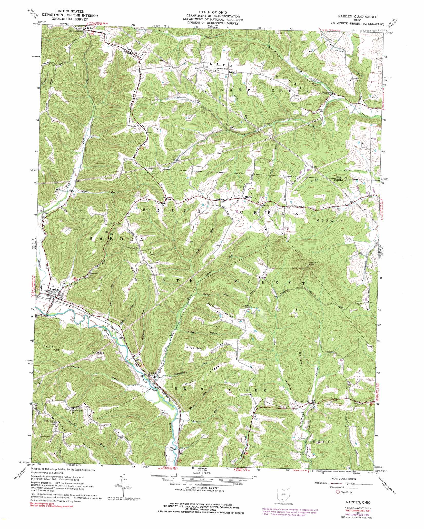
USGS Topo Quad 38083h2 - 1:24,000 scale
| Topo Map Name: | Rarden |
| USGS Topo Quad ID: | 38083h2 |
| Print Size: | ca. 21 1/4" wide x 27" high |
| Southeast Coordinates: | 38.875° N latitude / 83.125° W longitude |
| Map Center Coordinates: | 38.9375° N latitude / 83.1875° W longitude |
| U.S. State: | OH |
| Filename: | o38083h2.jpg |
| Download Map JPG Image: | Rarden topo map 1:24,000 scale |
| Map Type: | Topographic |
| Topo Series: | 7.5´ |
| Map Scale: | 1:24,000 |
| Source of Map Images: | United States Geological Survey (USGS) |
| Alternate Map Versions: |
Rarden OH 1961, updated 1963 Download PDF Buy paper map Rarden OH 1961, updated 1973 Download PDF Buy paper map Rarden OH 1961, updated 1976 Download PDF Buy paper map Rarden OH 1961, updated 1991 Download PDF Buy paper map Rarden OH 2010 Download PDF Buy paper map Rarden OH 2013 Download PDF Buy paper map Rarden OH 2016 Download PDF Buy paper map |
1:24,000 Topo Quads surrounding Rarden
Rainsboro |
Bainbridge |
Morgantown |
Summithill |
Waverly North |
Sinking Spring |
Byington |
Latham |
Piketon |
Waverly South |
Peebles |
Jaybird |
Rarden |
Wakefield |
Lucasville |
Lynx |
Blue Creek |
Otway |
West Portsmouth |
New Boston |
Concord |
Buena Vista |
Pond Run |
Friendship |
Portsmouth |
> Back to 38083e1 at 1:100,000 scale
> Back to 38082a1 at 1:250,000 scale
> Back to U.S. Topo Maps home
Rarden topo map: Gazetteer
Rarden: Parks
Brush Creek State Forest elevation 292m 958′Rarden: Populated Places
Duke elevation 373m 1223′Ladd elevation 329m 1079′
Mount Joy elevation 326m 1069′
Rarden elevation 189m 620′
Youngs elevation 182m 597′
Rarden: Post Offices
Duke Post Office (historical) elevation 373m 1223′Ladd Post Office (historical) elevation 328m 1076′
Mount Joy Post Office (historical) elevation 326m 1069′
Rarden Post Office elevation 189m 620′
Young Post Office (historical) elevation 180m 590′
Rarden: Ridges
Fen Ridge elevation 323m 1059′Ladd Ridge elevation 335m 1099′
Penn Ridge elevation 334m 1095′
Powell Ridge elevation 316m 1036′
Staley Ridge elevation 334m 1095′
Thatcher Ridge elevation 318m 1043′
Rarden: Streams
Abe Run elevation 183m 600′Chambers Run elevation 176m 577′
Drake Run elevation 235m 770′
Dry Run elevation 180m 590′
Jessie Run elevation 181m 593′
Kizzie Run elevation 201m 659′
Laurel Fork elevation 176m 577′
Left Fork Camp Creek elevation 201m 659′
Mullen Run elevation 180m 590′
Rock Run elevation 237m 777′
Salome Run elevation 222m 728′
Spunk Run elevation 195m 639′
Staley Run elevation 217m 711′
Sugarcamp Run elevation 183m 600′
Thompson Run elevation 180m 590′
Up Run elevation 231m 757′
Whites Run elevation 183m 600′
Rarden: Summits
Hoffer Hill elevation 336m 1102′Rarden: Valleys
Fen Hollow elevation 247m 810′Skidmore Hollow elevation 213m 698′
Toms Hollow elevation 207m 679′
Rarden digital topo map on disk
Buy this Rarden topo map showing relief, roads, GPS coordinates and other geographical features, as a high-resolution digital map file on DVD:
Western Virginia & Southern West Virginia
Buy digital topo maps: Western Virginia & Southern West Virginia